

סקירה כללית
כך מייבאים נתוני GeoJSON ממקור מקומי או מרוחק ומציגים אותם במפה. במדריך הזה אנחנו משתמשים במפה שלמטה כדי להמחיש טכניקות שונות לייבוא נתונים למפות.
בקטע שבהמשך מוצג כל הקוד שדרוש ליצירת המפה במדריך הזה.
TypeScript
let map: google.maps.Map; function initMap(): void { map = new google.maps.Map(document.getElementById("map") as HTMLElement, { zoom: 2, center: new google.maps.LatLng(2.8, -187.3), mapTypeId: "terrain", }); // Create a <script> tag and set the USGS URL as the source. const script = document.createElement("script"); // This example uses a local copy of the GeoJSON stored at // http://earthquake.usgs.gov/earthquakes/feed/v1.0/summary/2.5_week.geojsonp script.src = "https://developers.google.com/maps/documentation/javascript/examples/json/earthquake_GeoJSONP.js"; document.getElementsByTagName("head")[0].appendChild(script); } // Loop through the results array and place a marker for each // set of coordinates. const eqfeed_callback = function (results: any) { for (let i = 0; i < results.features.length; i++) { const coords = results.features[i].geometry.coordinates; const latLng = new google.maps.LatLng(coords[1], coords[0]); new google.maps.Marker({ position: latLng, map: map, }); } }; declare global { interface Window { initMap: () => void; eqfeed_callback: (results: any) => void; } } window.initMap = initMap; window.eqfeed_callback = eqfeed_callback;
JavaScript
let map; function initMap() { map = new google.maps.Map(document.getElementById("map"), { zoom: 2, center: new google.maps.LatLng(2.8, -187.3), mapTypeId: "terrain", }); // Create a <script> tag and set the USGS URL as the source. const script = document.createElement("script"); // This example uses a local copy of the GeoJSON stored at // http://earthquake.usgs.gov/earthquakes/feed/v1.0/summary/2.5_week.geojsonp script.src = "https://developers.google.com/maps/documentation/javascript/examples/json/earthquake_GeoJSONP.js"; document.getElementsByTagName("head")[0].appendChild(script); } // Loop through the results array and place a marker for each // set of coordinates. const eqfeed_callback = function (results) { for (let i = 0; i < results.features.length; i++) { const coords = results.features[i].geometry.coordinates; const latLng = new google.maps.LatLng(coords[1], coords[0]); new google.maps.Marker({ position: latLng, map: map, }); } }; window.initMap = initMap; window.eqfeed_callback = eqfeed_callback;
CSS
/* * Always set the map height explicitly to define the size of the div element * that contains the map. */ #map { height: 100%; } /* * Optional: Makes the sample page fill the window. */ html, body { height: 100%; margin: 0; padding: 0; }
HTML
<html>
<head>
<title>Earthquake Markers</title>
<link rel="stylesheet" type="text/css" href="./style.css" />
<script type="module" src="./index.js"></script>
</head>
<body>
<div id="map"></div>
<!--
The `defer` attribute causes the script to execute after the full HTML
document has been parsed. For non-blocking uses, avoiding race conditions,
and consistent behavior across browsers, consider loading using Promises. See
https://developers.google.com/maps/documentation/javascript/load-maps-js-api
for more information.
-->
<script
src="https://maps.googleapis.com/maps/api/js?key=AIzaSyB41DRUbKWJHPxaFjMAwdrzWzbVKartNGg&callback=initMap&v=weekly"
defer
></script>
</body>
</html>בתהליך טעינת נתונים
בקטע הזה מוסבר איך לטעון נתונים מאותו דומיין של אפליקציית Maps JavaScript API, או מדומיין אחר.
טעינת נתונים מאותו דומיין
שכבת הנתונים של מפות Google מספקת מאגר לנתונים גיאו-מרחביים שרירותיים (כולל GeoJSON). אם הנתונים שלכם נמצאים בקובץ שמארח באותו דומיין כמו האפליקציה שלכם ב-Maps JavaScript API, אתם יכולים לטעון אותו באמצעות השיטה map.data.loadGeoJson(). הקובץ צריך להיות באותו דומיין, אבל אפשר לארח אותו בתת-דומיין אחר. לדוגמה, אפשר לשלוח בקשה אל files.example.com מ-www.example.com.
map.data.loadGeoJson('data.json');
טעינת נתונים בדומיינים שונים
אתם יכולים גם לבקש נתונים מדומיין אחר, אם ההגדרה של הדומיין מאפשרת בקשה כזו. התקן להרשאה הזו נקרא שיתוף משאבים בין מקורות (CORS). אם דומיין מסוים מאפשר בקשות חוצות-דומיינים, כותרת התגובה שלו צריכה לכלול את ההצהרה הבאה:
Access-Control-Allow-Origin: *
כדי לבדוק אם CORS מופעל בדומיין, משתמשים בכלים למפתחים ב-Chrome (DevTools).

טעינת נתונים מדומיין כזה זהה לטעינת JSON מאותו דומיין:
map.data.loadGeoJson('http://www.CORS-ENABLED-SITE.com/data.json');
שליחת בקשת JSONP
כדי להשתמש בטכניקה הזו, דומיין היעד צריך לתמוך בבקשות ל-JSONP.
כדי לבקש JSONP, משתמשים ב-createElement() כדי להוסיף תג script לראש המסמך.
var script = document.createElement('script');
script.src = 'http://earthquake.usgs.gov/earthquakes/feed/v1.0/summary/2.5_week.geojsonp';
document.getElementsByTagName('head')[0].appendChild(script);
כשהסקריפט פועל, דומיין היעד מעביר את הנתונים כארגומנט לסקריפט אחר, שבדרך כלל נקרא callback(). דומיין היעד מגדיר את שם סקריפט הקריאה החוזרת, שהוא השם הראשון בדף כשכתובת היעד נטענת בדפדפן.
לדוגמה, טוענים את הכתובת http://earthquake.usgs.gov/earthquakes/feed/v1.0/summary/2.5_week.geojsonp בחלון הדפדפן כדי לחשוף את שם הקריאה החוזרת בתור eqfeed_callback.
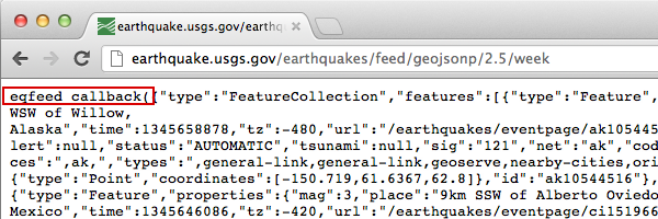
צריך להגדיר את סקריפט הקריאה החוזרת בקוד:
function eqfeed_callback(response) {
  map.data.addGeoJson(response);
}
משתמשים בשיטה addGeoJson() כדי למקם את נתוני ה-GeoJSON שנותחו במפה.
ייבוא אובייקטים גיאומטריים של GeoJSON
השיטה map.data.addGeoJson() דורשת אובייקט Feature או FeatureCollection של GeoJSON שעבר ניתוח. הוא לא מקבל ישירות אובייקטים גיאומטריים עצמאיים של GeoJSON (Point, MultiPoint, LineString, MultiLineString, Polygon, MultiPolygon או GeometryCollection).
אם מקור הנתונים או התגובה מה-API מחזירים אובייקט גיאומטרי עצמאי של GeoJSON בלי wrapper ברמה העליונה של "type": "Feature", צריך לעטוף אותו באובייקט Feature לפני שקוראים ל-map.data.addGeoJson().
לדוגמה, אם הגיאומטריה (כמו Polygon) היא אובייקט JavaScript מנותח, צריך לעטוף אותה באובייקט Feature:
const polygonGeometry = {
  type: "Polygon",
  coordinates: [
    [
      [-78.45, 35.82],
      [-78.41, 35.73],
      [-78.28, 35.66],
      [-78.45, 35.82],
    ],
  ],
};

const geoJsonFeature = {
  type: "Feature",
  geometry: polygonGeometry,
};

map.data.addGeoJson(geoJsonFeature);
אם הגיאומטריה מוחזרת כמחרוזת בפורמט JSON (לדוגמה, השדה polygon שמוחזר על ידי התראה על מזג אוויר או תגובה לגבי גבול), אפשר גם להוסיף כותרת בתחילת המחרוזת וסיכום בסופה כדי ליצור GeoJSON תקין Feature לפני שמנתחים אותו באמצעות JSON.parse():
const geojson_header = "{\"type\":\"Feature\", \"geometry\": ";
const geojson_footer = "}";

map.data.addGeoJson(
    JSON.parse(geojson_header + polygon + geojson_footer));
מידע נוסף על עבודה עם צורות גיאומטריות ומצולעים בשכבת הנתונים זמין במדריך למפתחים בנושא שכבת הנתונים.
עיצוב הנתונים
כדי לשנות את המראה של הנתונים, אפשר להוסיף נתוני GeoJSON לאובייקט Map. מידע נוסף על עיצוב הנתונים זמין במדריך למפתחים.
מידע נוסף
- GeoJSON הוא פורמט פתוח שנמצא בשימוש נרחב לקידוד נתונים גיאוגרפיים, והוא מבוסס על JSON (JavaScript Object Notation). כלים ושיטות של JavaScript שנועדו לנתוני JSON פועלים גם עם GeoJSON. מידע נוסף זמין במדריך למפתחים.
- JSONP מייצג JSON עם ריפוד. זו שיטת תקשורת שמשמשת בתוכניות JavaScript שפועלות בדפדפני אינטרנט, כדי לבקש נתונים משרת בדומיין אחר.