
Page Summary
-
This guide explains how to import and display GeoJSON data on Google Maps using JavaScript or TypeScript.
-
You can load GeoJSON data from your domain or a cross-origin domain that supports CORS.
-
If the remote domain only supports JSONP, you can use a script tag to fetch the data, but this approach has security risks and CORS is preferred if available.
-
Once loaded, GeoJSON data can be styled and customized using the Google Maps Data Layer.
-
This tutorial provides code examples and links to further resources for working with GeoJSON and Google Maps.
Overview
Learn how to import GeoJSON data from either a local or remote source, and display it on your map. This tutorial uses the map below to illustrate various techniques to import data into maps.
The section below displays the entire code you need to create the map in this tutorial.
TypeScript
let map: google.maps.Map; function initMap(): void { map = new google.maps.Map(document.getElementById("map") as HTMLElement, { zoom: 2, center: new google.maps.LatLng(2.8, -187.3), mapTypeId: "terrain", }); // Create a <script> tag and set the USGS URL as the source. const script = document.createElement("script"); // This example uses a local copy of the GeoJSON stored at // http://earthquake.usgs.gov/earthquakes/feed/v1.0/summary/2.5_week.geojsonp script.src = "https://developers.google.com/maps/documentation/javascript/examples/json/earthquake_GeoJSONP.js"; document.getElementsByTagName("head")[0].appendChild(script); } // Loop through the results array and place a marker for each // set of coordinates. const eqfeed_callback = function (results: any) { for (let i = 0; i < results.features.length; i++) { const coords = results.features[i].geometry.coordinates; const latLng = new google.maps.LatLng(coords[1], coords[0]); new google.maps.Marker({ position: latLng, map: map, }); } }; declare global { interface Window { initMap: () => void; eqfeed_callback: (results: any) => void; } } window.initMap = initMap; window.eqfeed_callback = eqfeed_callback;
JavaScript
let map; function initMap() { map = new google.maps.Map(document.getElementById("map"), { zoom: 2, center: new google.maps.LatLng(2.8, -187.3), mapTypeId: "terrain", }); // Create a <script> tag and set the USGS URL as the source. const script = document.createElement("script"); // This example uses a local copy of the GeoJSON stored at // http://earthquake.usgs.gov/earthquakes/feed/v1.0/summary/2.5_week.geojsonp script.src = "https://developers.google.com/maps/documentation/javascript/examples/json/earthquake_GeoJSONP.js"; document.getElementsByTagName("head")[0].appendChild(script); } // Loop through the results array and place a marker for each // set of coordinates. const eqfeed_callback = function (results) { for (let i = 0; i < results.features.length; i++) { const coords = results.features[i].geometry.coordinates; const latLng = new google.maps.LatLng(coords[1], coords[0]); new google.maps.Marker({ position: latLng, map: map, }); } }; window.initMap = initMap; window.eqfeed_callback = eqfeed_callback;
CSS
/* * Always set the map height explicitly to define the size of the div element * that contains the map. */ #map { height: 100%; } /* * Optional: Makes the sample page fill the window. */ html, body { height: 100%; margin: 0; padding: 0; }
HTML
<html>
<head>
<title>Earthquake Markers</title>
<link rel="stylesheet" type="text/css" href="./style.css" />
<script type="module" src="./index.js"></script>
</head>
<body>
<div id="map"></div>
<!--
The `defer` attribute causes the script to execute after the full HTML
document has been parsed. For non-blocking uses, avoiding race conditions,
and consistent behavior across browsers, consider loading using Promises. See
https://developers.google.com/maps/documentation/javascript/load-maps-js-api
for more information.
-->
<script
src="https://maps.googleapis.com/maps/api/js?key=AIzaSyB41DRUbKWJHPxaFjMAwdrzWzbVKartNGg&callback=initMap&v=weekly"
defer
></script>
</body>
</html>Loading data
This section shows you how to load data from either the same domain as your Maps JavaScript API application, or from a different one.
Loading data from the same domain
The Google Maps Data Layer
provides a container for arbitrary geospatial data
(including GeoJSON). If your data is in a file hosted on the same domain
as your Maps JavaScript API application, you can load it
using the map.data.loadGeoJson() method. The file must be on the same domain,
but you can host it in a different
subdomain. For example, you can make a request to files.example.com from
www.example.com.
map.data.loadGeoJson('data.json');
Loading data across domains
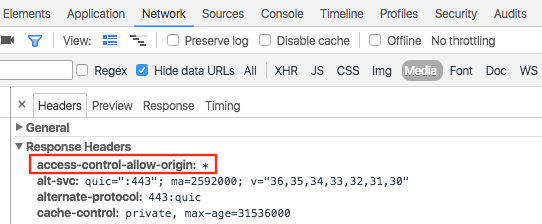
You can also request data from a domain other than your own, if the domain's configuration allows such a request. The standard for this permission is called Cross-origin resource sharing (CORS). If a domain has allowed cross-domain requests, its response header should include the following declaration:
Access-Control-Allow-Origin: *
Use the Chrome Developer Tools (DevTools) to find out if a domain has enabled CORS.
Loading data from such a domain is the same as loading JSON from the same domain:
map.data.loadGeoJson('http://www.CORS-ENABLED-SITE.com/data.json');
Requesting JSONP
The target domain must support requests for JSONP in order to use this technique.
To request JSONP, use createElement() to add a script tag
to the head of your document.
var script = document.createElement('script');
script.src = 'http://earthquake.usgs.gov/earthquakes/feed/v1.0/summary/2.5_week.geojsonp';
document.getElementsByTagName('head')[0].appendChild(script);
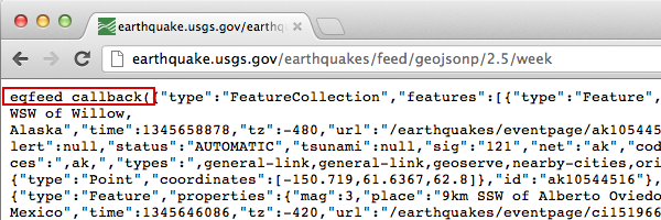
When the script runs, the target domain passes the data as an argument
to another script, usually named callback(). The target domain defines the
callback script name, which is the first name on the page when you load the
target URL in a browser.
For example, load
http://earthquake.usgs.gov/earthquakes/feed/v1.0/summary/2.5_week.geojsonp
in your browser window to reveal the callback name as eqfeed_callback.
You must define the callback script in your code:
function eqfeed_callback(response) {
  map.data.addGeoJson(response);
}
Use the addGeoJson() method to place the parsed GeoJSON data on the map.
Styling the data
You can change the appearance of your data by adding GeoJSON data to a Map object. Read the developer's guide for more information on styling your data.
Learn more
- GeoJSON is a widely used open format for encoding geographic data, based on JSON (JavaScript Object Notation). JavaScript tools and methods designed for JSON data also work with GeoJSON. Read the developer's guide for more information.
- JSONP stands for padded JSON. It is a communication method used in JavaScript programs that run in web browsers, to request data from a server in a different domain.