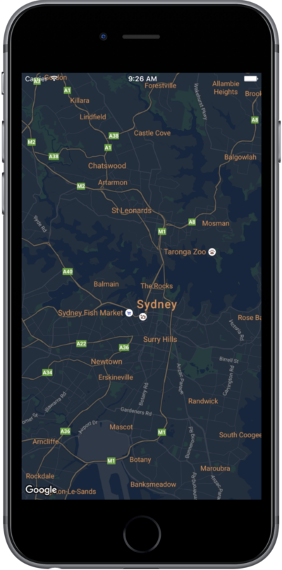
בדף הזה מוסבר בקצרה איך להגדיר סגנון למפה, באמצעות מצב לילה כדוגמה.
סקירה כללית
אפשרויות הסגנון מאפשרות להתאים אישית את התצוגה של סגנונות המפה הרגילים של Google, ולשנות את התצוגה החזותית של רכיבים כמו כבישים, פארקים, עסקים ונקודות עניין אחרות. כלומר, אתם יכולים להדגיש רכיבים מסוימים במפה או להתאים את המפה לסגנון של האפליקציה.
העיצוב פועל רק במפת kGMSTypeNormal.
החלת סגנונות על המפה
כדי להחיל סגנונות מפה בהתאמה אישית על מפה, קוראים ל-GMSMapStyle(...) כדי ליצור מופע של GMSMapStyle, ומעבירים כתובת URL לקובץ JSON מקומי או מחרוזת JSON שמכילה הגדרות סגנון. מקצים את המופע GMSMapStyle לנכס mapStyle של המפה.
importGoogleMapsclassMapStyling:UIViewController{// Set the status bar style to complement night-mode.overridevarpreferredStatusBarStyle:UIStatusBarStyle{return.lightContent}overridefuncloadView(){letcamera=GMSCameraPosition.camera(withLatitude:-33.86,longitude:151.20,zoom:14.0)letmapView=GMSMapView.map(withFrame:CGRect.zero,camera:camera)do{// Set the map style by passing the URL of the local file.ifletstyleURL=Bundle.main.url(forResource:"style",withExtension:"json"){mapView.mapStyle=tryGMSMapStyle(contentsOfFileURL:styleURL)}else{NSLog("Unable to find style.json")}}catch{NSLog("One or more of the map styles failed to load. \(error)")}self.view=mapView}}
Objective-C
#import "MapStyling.h"@importGoogleMaps;@interfaceMapStyling()@end@implementationMapStyling// Set the status bar style to complement night-mode.-(UIStatusBarStyle)preferredStatusBarStyle{returnUIStatusBarStyleLightContent;}-(void)loadView{GMSCameraPosition*camera=[GMSCameraPositioncameraWithLatitude:-33.86longitude:151.20zoom:12];GMSMapView*mapView=[GMSMapViewmapWithFrame:CGRectZerocamera:camera];mapView.myLocationEnabled=YES;NSBundle*mainBundle=[NSBundlemainBundle];NSURL*styleUrl=[mainBundleURLForResource:@"style"withExtension:@"json"];NSError*error;// Set the map style by passing the URL for style.json.GMSMapStyle*style=[GMSMapStylestyleWithContentsOfFileURL:styleUrlerror:&error];if(!style){NSLog(@"The style definition could not be loaded: %@",error);}mapView.mapStyle=style;self.view=mapView;}@end
כדי להגדיר את אפשרויות הסגנון, מוסיפים לפרויקט קובץ חדש בשם style.json ומדביקים בו את הצהרת הסגנון הבאה בפורמט JSON עבור סגנון של מצב לילה:
בדוגמאות הבאות מוצגת קריאה ל-GMSMapStyle(...) והעברה של משאב מחרוזת:
Swift
classMapStylingStringResource:UIViewController{letMapStyle="JSON_STYLE_GOES_HERE"// Set the status bar style to complement night-mode.overridevarpreferredStatusBarStyle:UIStatusBarStyle{return.lightContent}overridefuncloadView(){letcamera=GMSCameraPosition.camera(withLatitude:-33.86,longitude:151.20,zoom:14.0)letmapView=GMSMapView.map(withFrame:CGRect.zero,camera:camera)do{// Set the map style by passing a valid JSON string.mapView.mapStyle=tryGMSMapStyle(jsonString:MapStyle)}catch{NSLog("One or more of the map styles failed to load. \(error)")}self.view=mapView}}
Objective-C
@implementationMapStylingStringResource// Paste the JSON string to use.staticNSString*constkMapStyle=@"JSON_STYLE_GOES_HERE";// Set the status bar style to complement night-mode.-(UIStatusBarStyle)preferredStatusBarStyle{returnUIStatusBarStyleLightContent;}-(void)loadView{GMSCameraPosition*camera=[GMSCameraPositioncameraWithLatitude:-33.86longitude:151.20zoom:12];GMSMapView*mapView=[GMSMapViewmapWithFrame:CGRectZerocamera:camera];mapView.myLocationEnabled=YES;NSError*error;// Set the map style by passing a valid JSON string.GMSMapStyle*style=[GMSMapStylestyleWithJSONString:kMapStyleerror:&error];if(!style){NSLog(@"The style definition could not be loaded: %@",error);}mapView.mapStyle=style;self.view=mapView;}@end
כדי להגדיר את אפשרויות הסגנון, מדביקים את מחרוזת הסגנון הבאה כערך של המשתנה kMapStyle:
במפות עם סגנון מותאם אישית נעשה שימוש בשני מושגים כדי להחיל צבעים ושינויים אחרים בסגנון על מפה:
רכיבי הבחירה מציינים את הרכיבים הגיאוגרפיים שאפשר להגדיר להם סגנון במפה. הם כוללים כבישים, פארקים, מקווי מים ועוד, וגם את התוויות שלהם. הסלקטורים כוללים תכונות ורכיבים, שמצוינים כמאפיינים featureType ו-elementType.
סגנונות הם מאפייני צבע ונראות שאפשר להחיל על רכיבים במפה. הם מגדירים את הצבע שמוצג באמצעות שילוב של גוון, צבע, בהירות וערכי גמא.
אפשר להשתמש באשף הסגנונות של Maps Platform כדי ליצור במהירות אובייקט סגנונות בפורמט JSON. SDK של מפות ל-iOS תומך באותן הצהרות סגנון כמו Maps JavaScript API.
דוגמאות קוד מלאות
במאגר ApiDemos ב-GitHub יש דוגמאות שממחישות את השימוש בסגנון.
[[["התוכן קל להבנה","easyToUnderstand","thumb-up"],["התוכן עזר לי לפתור בעיה","solvedMyProblem","thumb-up"],["סיבה אחרת","otherUp","thumb-up"]],[["חסרים לי מידע או פרטים","missingTheInformationINeed","thumb-down"],["התוכן מורכב מדי או עם יותר מדי שלבים","tooComplicatedTooManySteps","thumb-down"],["התוכן לא עדכני","outOfDate","thumb-down"],["בעיה בתרגום","translationIssue","thumb-down"],["בעיה בדוגמאות/בקוד","samplesCodeIssue","thumb-down"],["סיבה אחרת","otherDown","thumb-down"]],["עדכון אחרון: 2026-06-19 (שעון UTC)."],[],["To customize map appearance, apply styles to the `kGMSTypeNormal` map type. Utilize `GMSMapStyle` by passing a URL for a local JSON file or a JSON string to the `mapStyle` property. Define styles with selectors (features and elements) and stylers (color, visibility). Create a `style.json` file for night-mode styling with the provided JSON or use a JSON string directly. Consider cloud customization for uniform styling across multiple apps. The Maps Platform Styling Wizard can help generate JSON style objects. Avoid mixing cloud and hardcoded styles.\n"]]