To style the fill and stroke for a boundary polygon, use a styling closure that
accepts a GMSPlaceFeature and returns a
GMSFeatureStyle to define style attributes. Then set the
style property to a styling closure, which contains styling logic.
Swift
letmapView=GMSMapView(frame:.zero,mapID:GMSMapID(identifier:"YOUR_MAP_ID"),camera:GMSCameraPosition(latitude:20.773,longitude:-156.01,zoom:12))letlayer=mapView.featureLayer(of:.locality)// Define a style with purpleletstyle=FeatureStyle(fill:.purple.withAlphaComponent(0.5),stroke:.purple,strokeWidth:3.0)// Apply the style to a single boundary.layer.style={($0.placeID=="ChIJ0zQtYiWsVHkRk8lRoB1RNPo"/* Hana, HI */)?style:nil}
Objective-C
GMSMapView*mapView=[GMSMapViewmapWithFrame:CGRectZeromapID:[GMSMapIDmapIDWithIdentifier:@"MAP_ID"]camera:[GMSCameraPositioncameraWithLatitude:20.773longitude:-156.01zoom:12]];GMSFeatureLayer<GMSPlaceFeature*>*layer=[mapViewfeatureLayerOfFeatureType:GMSFeatureTypeLocality];// Define a style with purple fill and border.GMSFeatureStyle*style=[GMSFeatureStylestyleWithFillColor:[[UIColorpurpleColor]colorWithAlphaComponent:0.5]strokeColor:[UIColorpurpleColor]strokeWidth:3.0];// Apply the style to a single boundary.layer.style=^(GMSPlaceFeature*feature){return[feature.placeIDisEqual:@"ChIJ0zQtYiWsVHkRk8lRoB1RNPo"/* Hana, HI */]?style:nil;};
[[["Easy to understand","easyToUnderstand","thumb-up"],["Solved my problem","solvedMyProblem","thumb-up"],["Other","otherUp","thumb-up"]],[["Missing the information I need","missingTheInformationINeed","thumb-down"],["Too complicated / too many steps","tooComplicatedTooManySteps","thumb-down"],["Out of date","outOfDate","thumb-down"],["Samples / code issue","samplesCodeIssue","thumb-down"],["Other","otherDown","thumb-down"]],["Last updated 2025-08-18 UTC."],[[["\u003cp\u003eThis documentation explains how to style the fill and stroke of boundary polygons using a styling closure that takes a \u003ccode\u003eGMSPlaceFeature\u003c/code\u003e and returns a \u003ccode\u003eGMSFeatureStyle\u003c/code\u003e.\u003c/p\u003e\n"],["\u003cp\u003eThe styling closure defines the style attributes for the polygon, such as fill color, stroke color, and stroke width.\u003c/p\u003e\n"],["\u003cp\u003eStyling Places data might require integrating the Places SDK for iOS, although it's not always mandatory.\u003c/p\u003e\n"],["\u003cp\u003e
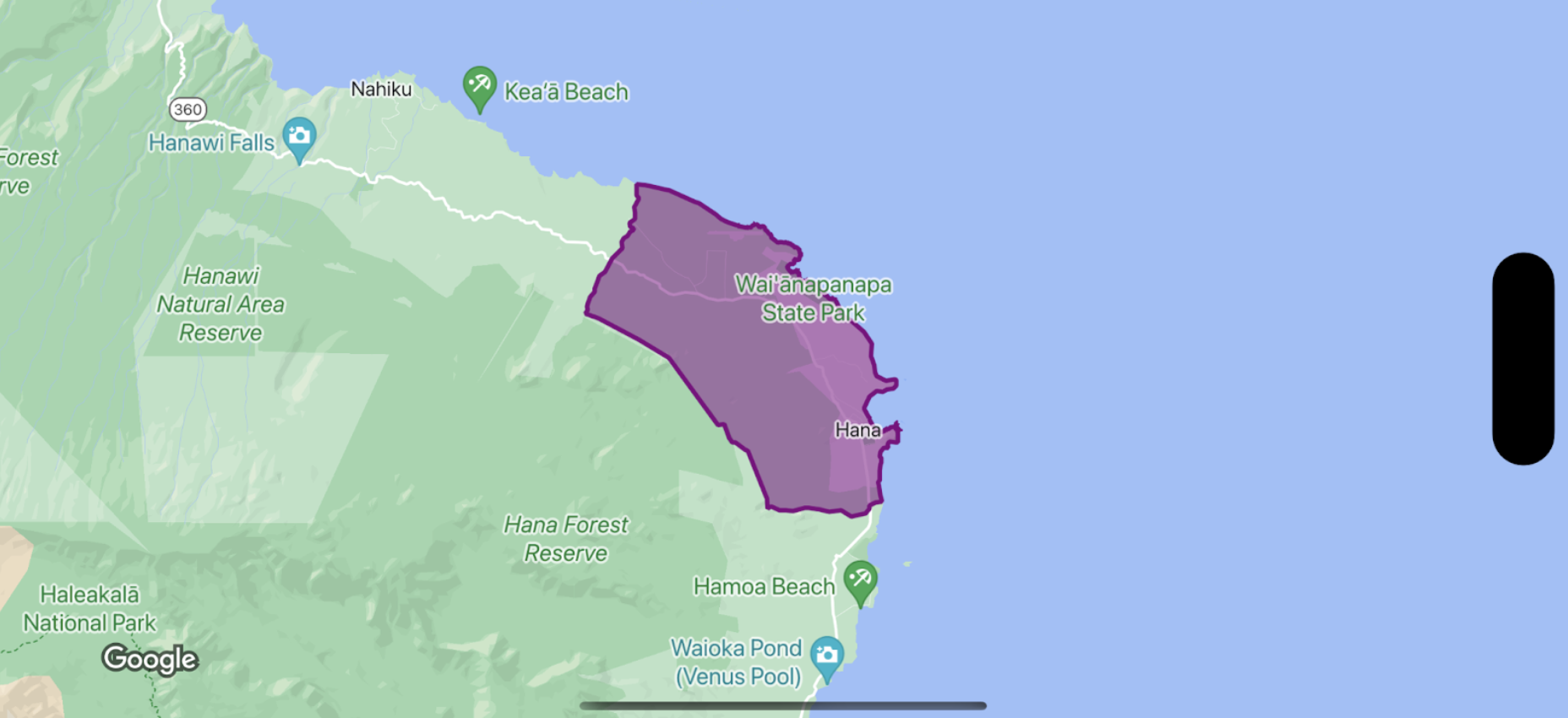
Code examples in Swift and Objective-C demonstrate how to apply a purple style to a specific boundary polygon using its place ID.\u003c/p\u003e\n"]]],[],null,["Select platform: [Android](/maps/documentation/android-sdk/dds-boundaries/style-polygon \"View this page for the Android platform docs.\") [iOS](/maps/documentation/ios-sdk/dds-boundaries/style-polygon \"View this page for the iOS platform docs.\") [JavaScript](/maps/documentation/javascript/dds-boundaries/style-polygon \"View this page for the JavaScript platform docs.\")\n\n\u003cbr /\u003e\n\nTo style the fill and stroke for a boundary polygon, use a styling closure that\naccepts a [`GMSPlaceFeature`](/maps/documentation/ios-sdk/reference/objc/Classes/GMSPlaceFeature) and returns a\n[`GMSFeatureStyle`](/maps/documentation/ios-sdk/reference/objc/Classes/GMSFeatureStyle) to define style attributes. Then set the\nstyle property to a styling closure, which contains styling logic.\n\n**Important:** While not required for all capabilities, styling of Places data may require integration with the [Places SDK for iOS](/maps/documentation/places/ios-sdk). \n\nSwift \n\n```swift\nlet mapView = GMSMapView(frame: .zero, mapID: GMSMapID(identifier: \"YOUR_MAP_ID\"), camera: GMSCameraPosition(latitude: 20.773, longitude: -156.01, zoom: 12))\n\nlet layer = mapView.featureLayer(of: .locality)\n\n// Define a style with purple\nlet style = FeatureStyle(fill: .purple.withAlphaComponent(0.5), stroke: .purple, strokeWidth: 3.0)\n\n// Apply the style to a single boundary.\nlayer.style = { ($0.placeID == \"ChIJ0zQtYiWsVHkRk8lRoB1RNPo\"/* Hana, HI */) ? style : nil }\n```\n\nObjective-C \n\n```objective-c\nGMSMapView *mapView = [GMSMapView mapWithFrame:CGRectZero mapID:[GMSMapID mapIDWithIdentifier:@\"MAP_ID\"] camera:[GMSCameraPosition cameraWithLatitude: 20.773 longitude: -156.01 zoom:12]];\n\nGMSFeatureLayer\u003cGMSPlaceFeature *\u003e *layer = [mapView featureLayerOfFeatureType:GMSFeatureTypeLocality];\n\n// Define a style with purple fill and border.\nGMSFeatureStyle *style = [GMSFeatureStyle styleWithFillColor:[[UIColor purpleColor] colorWithAlphaComponent:0.5] strokeColor:[UIColor purpleColor] strokeWidth:3.0];\n\n// Apply the style to a single boundary.\nlayer.style = ^(GMSPlaceFeature *feature) {\n return [feature.placeID isEqual:@\"ChIJ0zQtYiWsVHkRk8lRoB1RNPo\"/* Hana, HI */] ? style : nil;\n};\n```"]]