

نظرة عامة
تعرَّف على كيفية استيراد بيانات GeoJSON من مصدر محلي أو بعيد، وعرضها على خريطتك. يستخدم هذا البرنامج التعليمي الخريطة أدناه لتوضيح تقنيات مختلفة لاستيراد البيانات إلى الخرائط.
يعرض القسم أدناه الرمز البرمجي الكامل الذي تحتاج إليه لإنشاء الخريطة في هذا البرنامج التعليمي.
TypeScript
let map: google.maps.Map; function initMap(): void { map = new google.maps.Map(document.getElementById("map") as HTMLElement, { zoom: 2, center: new google.maps.LatLng(2.8, -187.3), mapTypeId: "terrain", }); // Create a <script> tag and set the USGS URL as the source. const script = document.createElement("script"); // This example uses a local copy of the GeoJSON stored at // http://earthquake.usgs.gov/earthquakes/feed/v1.0/summary/2.5_week.geojsonp script.src = "https://developers.google.com/maps/documentation/javascript/examples/json/earthquake_GeoJSONP.js"; document.getElementsByTagName("head")[0].appendChild(script); } // Loop through the results array and place a marker for each // set of coordinates. const eqfeed_callback = function (results: any) { for (let i = 0; i < results.features.length; i++) { const coords = results.features[i].geometry.coordinates; const latLng = new google.maps.LatLng(coords[1], coords[0]); new google.maps.Marker({ position: latLng, map: map, }); } }; declare global { interface Window { initMap: () => void; eqfeed_callback: (results: any) => void; } } window.initMap = initMap; window.eqfeed_callback = eqfeed_callback;
JavaScript
let map; function initMap() { map = new google.maps.Map(document.getElementById("map"), { zoom: 2, center: new google.maps.LatLng(2.8, -187.3), mapTypeId: "terrain", }); // Create a <script> tag and set the USGS URL as the source. const script = document.createElement("script"); // This example uses a local copy of the GeoJSON stored at // http://earthquake.usgs.gov/earthquakes/feed/v1.0/summary/2.5_week.geojsonp script.src = "https://developers.google.com/maps/documentation/javascript/examples/json/earthquake_GeoJSONP.js"; document.getElementsByTagName("head")[0].appendChild(script); } // Loop through the results array and place a marker for each // set of coordinates. const eqfeed_callback = function (results) { for (let i = 0; i < results.features.length; i++) { const coords = results.features[i].geometry.coordinates; const latLng = new google.maps.LatLng(coords[1], coords[0]); new google.maps.Marker({ position: latLng, map: map, }); } }; window.initMap = initMap; window.eqfeed_callback = eqfeed_callback;
CSS
/* * Always set the map height explicitly to define the size of the div element * that contains the map. */ #map { height: 100%; } /* * Optional: Makes the sample page fill the window. */ html, body { height: 100%; margin: 0; padding: 0; }
HTML
<html>
<head>
<title>Earthquake Markers</title>
<link rel="stylesheet" type="text/css" href="./style.css" />
<script type="module" src="./index.js"></script>
</head>
<body>
<div id="map"></div>
<!--
The `defer` attribute causes the script to execute after the full HTML
document has been parsed. For non-blocking uses, avoiding race conditions,
and consistent behavior across browsers, consider loading using Promises. See
https://developers.google.com/maps/documentation/javascript/load-maps-js-api
for more information.
-->
<script
src="https://maps.googleapis.com/maps/api/js?key=AIzaSyB41DRUbKWJHPxaFjMAwdrzWzbVKartNGg&callback=initMap&v=weekly"
defer
></script>
</body>
</html>جارٍ تحميل البيانات
يوضّح لك هذا القسم كيفية تحميل البيانات من النطاق نفسه الذي يستخدمه تطبيق Maps JavaScript API أو من نطاق مختلف.
تحميل البيانات من النطاق نفسه
توفّر طبقة بيانات "خرائط Google" حاوية للبيانات الجغرافية المكانية العشوائية (بما في ذلك GeoJSON). إذا كانت بياناتك في ملف مستضاف على النطاق نفسه
الذي يستضيف تطبيق Maps JavaScript API، يمكنك تحميلها
باستخدام طريقة map.data.loadGeoJson(). يجب أن يكون الملف على النطاق نفسه، ولكن يمكنك استضافته في نطاق فرعي مختلف. على سبيل المثال، يمكنك إرسال طلب إلى files.example.com من www.example.com.
map.data.loadGeoJson('data.json');
تحميل البيانات على جميع النطاقات
يمكنك أيضًا طلب بيانات من نطاق آخر غير نطاقك، إذا كان إعداد النطاق يسمح بذلك. يُطلق على معيار هذا الإذن اسم مشاركة الموارد متعدّدة المصادر (CORS). إذا سمح نطاق بطلبات من نطاقات أخرى، يجب أن تتضمّن ترويسة الردّ الإقرار التالي:
Access-Control-Allow-Origin: *
استخدِم أدوات مطوّري برامج Chrome (DevTools) لمعرفة ما إذا كان أحد النطاقات قد فعّل سياسة مشاركة الموارد المتعدّدة المصادر (CORS).
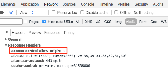
يُعدّ تحميل البيانات من نطاق مماثل كتحميل JSON من النطاق نفسه:
map.data.loadGeoJson('http://www.CORS-ENABLED-SITE.com/data.json');
طلب JSONP
يجب أن يتيح النطاق المستهدف طلبات JSONP لاستخدام هذه الطريقة.
لطلب JSONP، استخدِم createElement() لإضافة علامة script إلى رأس المستند.
var script = document.createElement('script');
script.src = 'http://earthquake.usgs.gov/earthquakes/feed/v1.0/summary/2.5_week.geojsonp';
document.getElementsByTagName('head')[0].appendChild(script);
عند تشغيل النص البرمجي، يمرر النطاق المستهدف البيانات كوسيطة إلى نص برمجي آخر، يُسمى عادةً callback(). يحدّد النطاق المستهدَف اسم النص البرمجي لوظيفة الاستدعاء، وهو الاسم الأول في الصفحة عند تحميل عنوان URL المستهدَف في المتصفّح.
على سبيل المثال، حمِّل
http://earthquake.usgs.gov/earthquakes/feed/v1.0/summary/2.5_week.geojsonp
في نافذة المتصفّح لعرض اسم معاودة الاتصال على أنّه eqfeed_callback.
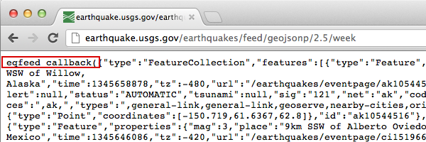
يجب تحديد نص برمجي لوظيفة ردّ الاتصال في الرمز الخاص بك:
function eqfeed_callback(response) {
  map.data.addGeoJson(response);
}
استخدِم الطريقة addGeoJson() لوضع بيانات GeoJSON التي تم تحليلها على الخريطة.
استيراد أشكال GeoJSON الهندسية
يتطلّب الإجراء map.data.addGeoJson() عنصر Feature أو FeatureCollection من نوع GeoJSON تم تحليله. ولا يقبل عناصر GeoJSON الهندسية المستقلة (Point أو MultiPoint أو LineString أو MultiLineString أو Polygon أو MultiPolygon أو GeometryCollection) مباشرةً.
إذا كان مصدر البيانات أو استجابة واجهة برمجة التطبيقات يعرضان عنصرًا هندسيًا مستقلًا بتنسيق GeoJSON بدون غلاف "type": "Feature" على المستوى الأعلى، عليك تضمينه في عنصر Feature قبل طلب map.data.addGeoJson().
على سبيل المثال، إذا كانت الهندسة (مثل Polygon) عبارة عن كائن JavaScript تم تحليله، يمكنك تضمينه في كائن Feature:
const polygonGeometry = {
  type: "Polygon",
  coordinates: [
    [
      [-78.45, 35.82],
      [-78.41, 35.73],
      [-78.28, 35.66],
      [-78.45, 35.82],
    ],
  ],
};

const geoJsonFeature = {
  type: "Feature",
  geometry: polygonGeometry,
};

map.data.addGeoJson(geoJsonFeature);
إذا تم عرض الشكل الهندسي كسلسلة بتنسيق JSON (على سبيل المثال، الحقل polygon الذي يعرضه تنبيه بشأن الطقس أو ردّ بشأن الحدود)، يمكنك أيضًا إضافة عنوان في البداية وتذييل في النهاية لتكوين Feature GeoJSON صالح قبل تحليله باستخدام JSON.parse():
const geojson_header = "{\"type\":\"Feature\", \"geometry\": ";
const geojson_footer = "}";

map.data.addGeoJson(
    JSON.parse(geojson_header + polygon + geojson_footer));
لمزيد من المعلومات حول استخدام الأشكال الهندسية والمضلّعات في طبقة البيانات، يُرجى الاطّلاع على دليل مطوّري طبقة البيانات.
تصميم البيانات
يمكنك تغيير مظهر بياناتك من خلال إضافة بيانات GeoJSON إلى عنصر Map. اطّلِع على دليل المطوِّر للحصول على مزيد من المعلومات حول تنسيق بياناتك.
مزيد من المعلومات
- GeoJSON هو تنسيق مفتوح مستخدَم على نطاق واسع لترميز البيانات الجغرافية، ويستند إلى JSON (JavaScript Object Notation). تعمل أدوات JavaScript وطرقها المصمَّمة لبيانات JSON أيضًا مع GeoJSON. يمكنك الاطّلاع على دليل المطوِّر للحصول على مزيد من المعلومات.
- يشير JSONP إلى JSON المحشو. وهي طريقة تواصل تُستخدَم في برامج JavaScript التي تعمل في متصفّحات الويب لطلب بيانات من خادم في نطاق مختلف.