Page Summary
-
Multiple datasets are available for monitoring and analyzing fire events, including active fire detections, burned area products, and indices related to fire risk.
-
Several datasets provide near real-time active fire data from instruments like MODIS and VIIRS, with some offering higher spatial resolution.
-
Datasets are provided at various temporal resolutions, including daily, 8-day, and monthly composites, and cover global or regional extents.
-
Some datasets focus on historical fire regimes, intervals, and vegetation characteristics related to fire risk and succession.
-
Specific datasets like the Keetch-Byram Drought Index and Wildfire Risk to Communities provide information related to fire potential and the impact on communities.
-
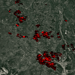
FIRMS: Fire Information for Resource Management System
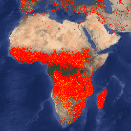
The Earth Engine version of the Fire Information for Resource Management System (FIRMS) dataset contains the LANCE fire detection product in rasterized form. The near real-time (NRT) active fire locations are processed by LANCE using the standard MODIS MOD14/MYD14 Fire and Thermal Anomalies product. Each … eosdis fire firms geophysical hotspot lance -
FORMA Alert Thresholds
NOTE from WRI: WRI decided to stop updating FORMA alerts. The goal was to simplify the Global Forest Watch user experience and reduce redundancy. We found that Terra-i and GLAD were more frequently used. Moreover, using GLAD as a standard, found that Terra-i outperformed FORMA … daily deforestation fire forest forma gfw -
FORMA Alerts
NOTE from WRI: WRI decided to stop updating FORMA alerts. The goal was to simplify the Global Forest Watch user experience and reduce redundancy. We found that Terra-i and GLAD were more frequently used. Moreover, using GLAD as a standard, found that Terra-i outperformed FORMA … daily deforestation fire forest forma gfw -
FORMA Raw Output FIRMS
NOTE from WRI: WRI decided to stop updating FORMA alerts. The goal was to simplify the Global Forest Watch user experience and reduce redundancy. We found that Terra-i and GLAD were more frequently used. Moreover, using GLAD as a standard, found that Terra-i outperformed FORMA … daily deforestation fire forest forma gfw -
FireCCI51: MODIS Fire_cci Burned Area Pixel Product, Version 5.1
The MODIS Fire_cci Burned Area pixel product version 5.1 (FireCCI51) is a monthly global ~250m spatial resolution dataset containing information on burned area as well as ancillary data. It is based on surface reflectance in the Near Infrared (NIR) band from the MODIS instrument onboard … burn cci climate-change copernicus esa fire -
GOES-16 FDCC Series ABI Level 2 Fire/Hot Spot Characterization CONUS
The Fire (HSC) product contains four images: one in the form of a fire mask and the other three with pixel values identifying fire temperature, fire area, and fire radiative power. The ABI L2+ FHS metadata mask assigns a flag to every earth-navigated pixel that … abi fdc fire goes goes-16 goes-east -
GOES-16 FDCF Series ABI Level 2 Fire/Hot Spot Characterization Full Disk
The Fire (HSC) product contains four images: one in the form of a fire mask and the other three with pixel values identifying fire temperature, fire area, and fire radiative power. The ABI L2+ FHS metadata mask assigns a flag to every earth-navigated pixel that … abi fdc fire goes goes-16 goes-east -
GOES-17 FDCC Series ABI Level 2 Fire/Hot Spot Characterization CONUS
The Fire (HSC) product contains four images: one in the form of a fire mask and the other three with pixel values identifying fire temperature, fire area, and fire radiative power. The ABI L2+ FHS metadata mask assigns a flag to every earth-navigated pixel that … abi fdc fire goes goes-17 goes-s -
GOES-17 FDCF Series ABI Level 2 Fire/Hot Spot Characterization Full Disk

The Fire (HSC) product contains four images: one in the form of a fire mask and the other three with pixel values identifying fire temperature, fire area, and fire radiative power. The ABI L2+ FHS metadata mask assigns a flag to every earth-navigated pixel that … abi fdc fire goes goes-17 goes-s -
GOES-18 FDCC Series ABI Level 2 Fire/Hot Spot Characterization CONUS

The Fire (HSC) product contains four images: one in the form of a fire mask and the other three with pixel values identifying fire temperature, fire area, and fire radiative power. The ABI L2+ FHS metadata mask assigns a flag to every earth-navigated pixel that … abi fdc fire goes goes-18 goes-t -
GOES-18 FDCF Series ABI Level 2 Fire/Hot Spot Characterization Full Disk
The Fire (HSC) product contains four images: one in the form of a fire mask and the other three with pixel values identifying fire temperature, fire area, and fire radiative power. The ABI L2+ FHS metadata mask assigns a flag to every earth-navigated pixel that … abi fdc fire goes goes-18 goes-t -
GOES-19 FDCC Series ABI Level 2 Fire/Hot Spot Characterization CONUS
GOES satellites are geostationary weather satellites run by NOAA. The Fire (HSC) product contains four images: one in the form of a fire mask and the other three with pixel values identifying fire temperature, fire area, and fire radiative power. The ABI L2+ FHS metadata … abi fdc fire goes goes-19 goes-east -
GOES-19 FDCF Series ABI Level 2 Fire/Hot Spot Characterization Full Disk
The Fire (HSC) product contains four images: one in the form of a fire mask and the other three with pixel values identifying fire temperature, fire area, and fire radiative power. The ABI L2+ FHS metadata mask assigns a flag to every earth-navigated pixel that … abi fdc fire goes goes-19 goes-east -
GlobFire Daily Fire Event Detection Based on MCD64A1
Fire boundaries based on the MODIS dataset MCD64A1. The data were computed based on an algorithm that relies on encoding in a graph structure a space-time relationship among patches of burned areas. Each fire has a unique number identifying the event. area burnt disaster fire globfire mcd64a1 -
GlobFire Final Fire Event Detection Based on MCD64A1

Fire boundaries based on the MODIS dataset MCD64A1. The data were computed based on an algorithm that relies on encoding in a graph structure a space-time relationship among patches of burned areas. Each fire has a unique number identifying the event. area burnt disaster fire globfire mcd64a1 -
KBDI: Keetch-Byram Drought Index
Keetch-Byram Drought Index (KBDI) is a continuous reference scale for estimating the dryness of the soil and duff layers. The index increases for each day without rain (the amount of increase depends on the daily high temperature) and decreases when it rains. This system is … drought fire rainfall -
LANDFIRE BPS (Biophysical Settings) v1.4.0

LANDFIRE (LF), Landscape Fire and Resource Management Planning Tools, is a shared program between the wildland fire management programs of the U.S. Department of Agriculture's Forest Service, U.S. Department of the Interior's Geological Survey, and The Nature Conservancy. LANDFIRE (LF) layers are created using predictive … doi fire forest-biomass landfire nature-conservancy usda -
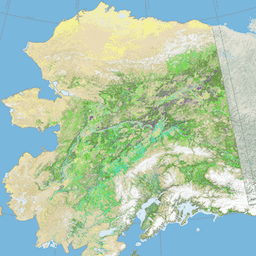
LANDFIRE ESP AK (Environmental Site Potential) v1.2.0
LANDFIRE (LF), Landscape Fire and Resource Management Planning Tools, is a shared program between the wildland fire management programs of the U.S. Department of Agriculture's Forest Service, U.S. Department of the Interior's Geological Survey, and The Nature Conservancy. LANDFIRE (LF) layers are created using predictive … doi fire forest-biomass landfire nature-conservancy usda -
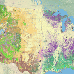
LANDFIRE ESP CONUS (Environmental Site Potential) v1.2.0

LANDFIRE (LF), Landscape Fire and Resource Management Planning Tools, is a shared program between the wildland fire management programs of the U.S. Department of Agriculture's Forest Service, U.S. Department of the Interior's Geological Survey, and The Nature Conservancy. LANDFIRE (LF) layers are created using predictive … doi fire forest-biomass landfire nature-conservancy usda -
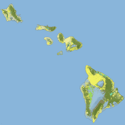
LANDFIRE ESP HI (Environmental Site Potential) v1.2.0
LANDFIRE (LF), Landscape Fire and Resource Management Planning Tools, is a shared program between the wildland fire management programs of the U.S. Department of Agriculture's Forest Service, U.S. Department of the Interior's Geological Survey, and The Nature Conservancy. LANDFIRE (LF) layers are created using predictive … doi fire forest-biomass landfire nature-conservancy usda -
LANDFIRE EVC (Existing Vegetation Cover) v1.4.0

LANDFIRE (LF), Landscape Fire and Resource Management Planning Tools, is a shared program between the wildland fire management programs of the U.S. Department of Agriculture's Forest Service, U.S. Department of the Interior's Geological Survey, and The Nature Conservancy. LANDFIRE (LF) layers are created using predictive … doi fire forest-biomass landfire nature-conservancy usda -
LANDFIRE EVH (Existing Vegetation Height) v1.4.0
LANDFIRE (LF), Landscape Fire and Resource Management Planning Tools, is a shared program between the wildland fire management programs of the U.S. Department of Agriculture's Forest Service, U.S. Department of the Interior's Geological Survey, and The Nature Conservancy. LANDFIRE (LF) layers are created using predictive … doi fire forest-biomass landfire nature-conservancy usda -
LANDFIRE EVT (Existing Vegetation Type) v1.4.0

LANDFIRE (LF), Landscape Fire and Resource Management Planning Tools, is a shared program between the wildland fire management programs of the U.S. Department of Agriculture's Forest Service, U.S. Department of the Interior's Geological Survey, and The Nature Conservancy. LANDFIRE (LF) layers are created using predictive … doi fire forest-biomass landfire nature-conservancy usda -
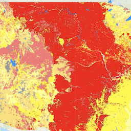
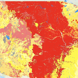
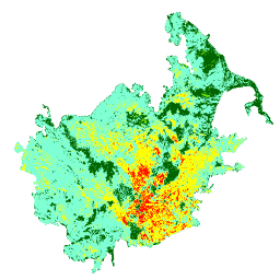
LANDFIRE FRG (Fire Regime Groups) v1.2.0

LANDFIRE (LF), Landscape Fire and Resource Management Planning Tools, is a shared program between the wildland fire management programs of the U.S. Department of Agriculture's Forest Service, U.S. Department of the Interior's Geological Survey, and The Nature Conservancy. Landfire (LF) Historical fire regimes, intervals, and … doi fire landfire nature-conservancy usda usgs -
LANDFIRE MFRI (Mean Fire Return Interval) v1.2.0

LANDFIRE (LF), Landscape Fire and Resource Management Planning Tools, is a shared program between the wildland fire management programs of the U.S. Department of Agriculture's Forest Service, U.S. Department of the Interior's Geological Survey, and The Nature Conservancy. Landfire (LF) Historical fire regimes, intervals, and … doi fire landfire nature-conservancy usda usgs -
LANDFIRE PLS (Percent Low-severity Fire) v1.2.0
LANDFIRE (LF), Landscape Fire and Resource Management Planning Tools, is a shared program between the wildland fire management programs of the U.S. Department of Agriculture's Forest Service, U.S. Department of the Interior's Geological Survey, and The Nature Conservancy. Landfire (LF) Historical fire regimes, intervals, and … doi fire landfire nature-conservancy usda usgs -
LANDFIRE PMS (Percent of Mixed-severity Fire) v1.2.0

LANDFIRE (LF), Landscape Fire and Resource Management Planning Tools, is a shared program between the wildland fire management programs of the U.S. Department of Agriculture's Forest Service, U.S. Department of the Interior's Geological Survey, and The Nature Conservancy. Landfire (LF) Historical fire regimes, intervals, and … doi fire landfire nature-conservancy usda usgs -
LANDFIRE PRS (Percent of Replacement-severity Fire) v1.2.0

LANDFIRE (LF), Landscape Fire and Resource Management Planning Tools, is a shared program between the wildland fire management programs of the U.S. Department of Agriculture's Forest Service, U.S. Department of the Interior's Geological Survey, and The Nature Conservancy. Landfire (LF) Historical fire regimes, intervals, and … doi fire landfire nature-conservancy usda usgs -
LANDFIRE SClass (Succession Classes) v1.4.0
LANDFIRE (LF), Landscape Fire and Resource Management Planning Tools, is a shared program between the wildland fire management programs of the U.S. Department of Agriculture's Forest Service, U.S. Department of the Interior's Geological Survey, and The Nature Conservancy. Landfire (LF) Historical fire regimes, intervals, and … doi fire landfire nature-conservancy usda usgs -
LANDFIRE VCC (Vegetation Condition Class) v1.4.0

LANDFIRE (LF), Landscape Fire and Resource Management Planning Tools, is a shared program between the wildland fire management programs of the U.S. Department of Agriculture's Forest Service, U.S. Department of the Interior's Geological Survey, and The Nature Conservancy. Landfire (LF) Historical fire regimes, intervals, and … doi fire landfire nature-conservancy usda usgs -
LANDFIRE VDep (Vegetation Departure) v1.4.0

LANDFIRE (LF), Landscape Fire and Resource Management Planning Tools, is a shared program between the wildland fire management programs of the U.S. Department of Agriculture's Forest Service, U.S. Department of the Interior's Geological Survey, and The Nature Conservancy. Landfire (LF) Historical fire regimes, intervals, and … doi fire landfire nature-conservancy usda usgs -
Landsat Collection 2 Tier 1 Level 2 32-Day BAI Composite
These Landsat Collection 2 Tier 1 Level 2 composites are made from Tier 1 Level 2 orthorectified scenes. The Burn Area Index (BAI) is generated from the Red and Near-IR bands, and measures the spectral distance of each pixel from a reference spectral point (the … bai fire landsat landsat-composite usgs vegetation-indices -
Landsat Collection 2 Tier 1 Level 2 32-Day NBR Composite

These Landsat Collection 2 Tier 1 Level 2 composites are made from Tier 1 Level 2 orthorectified scenes. The Normalized Burn Ratio Thermal (NBRT) index is generated from the Near-IR, Mid-IR (2215 nm), and Thermal bands, and has a range from -1.0 to 1.0. See … fire landsat landsat-composite nbrt usgs vegetation-indices -
Landsat Collection 2 Tier 1 Level 2 8-Day BAI Composite
These Landsat Collection 2 Tier 1 Level 2 composites are made from Tier 1 Level 2 orthorectified scenes. The Burn Area Index (BAI) is generated from the Red and Near-IR bands, and measures the spectral distance of each pixel from a reference spectral point (the … bai fire landsat landsat-composite usgs vegetation-indices -
Landsat Collection 2 Tier 1 Level 2 8-Day NBR Composite
These Landsat Collection 2 Tier 1 Level 2 composites are made from Tier 1 Level 2 orthorectified scenes. The Normalized Burn Ratio Thermal (NBRT) index is generated from the Near-IR, Mid-IR (2215 nm), and Thermal bands, and has a range from -1.0 to 1.0. See … fire landsat landsat-composite nbrt usgs vegetation-indices -
Landsat Collection 2 Tier 1 Level 2 Annual BAI Composite
These Landsat Collection 2 Tier 1 Level 2 composites are made from Tier 1 Level 2 orthorectified scenes. The Burn Area Index (BAI) is generated from the Red and Near-IR bands, and measures the spectral distance of each pixel from a reference spectral point (the … bai fire landsat landsat-composite usgs vegetation-indices -
Landsat Collection 2 Tier 1 Level 2 Annual NBR Composite
These Landsat Collection 2 Tier 1 Level 2 composites are made from Tier 1 Level 2 orthorectified scenes. The Normalized Burn Ratio Thermal (NBRT) index is generated from the Near-IR, Mid-IR (2215 nm), and Thermal bands, and has a range from -1.0 to 1.0. See … fire landsat landsat-composite nbrt usgs vegetation-indices -
MCD64A1.061 MODIS Burned Area Monthly Global 500m
The Terra and Aqua combined MCD64A1 Version 6.1 Burned Area data product is a monthly, global gridded 500m product containing per-pixel burned-area and quality information. The MCD64A1 burned-area mapping approach employs 500m MODIS Surface Reflectance imagery coupled with 1km MODIS active fire observations. The algorithm … burn change-detection fire geophysical global mcd64a1 -
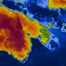
MOD14A1.061: Terra Thermal Anomalies & Fire Daily Global 1km

The MOD14A1 V6.1 dataset provides daily fire mask composites at 1km resolution derived from the MODIS 4- and 11-micrometer radiances. The fire detection strategy is based on absolute detection of a fire (when the fire strength is sufficient to detect), and on detection relative to … daily fire global modis nasa terra -
MOD14A2.061: Terra Thermal Anomalies & Fire 8-Day Global 1km
The MOD14A2 V6.1 dataset provides 8-day fire mask composites at 1km resolution. It contains the maximum value of the individual pixel classes over the compositing period. Along with the fire mask, an associated quality information layer is also provided. Documentation: User's Guide Algorithm Theoretical Basis … 8-day fire global modis nasa terra -
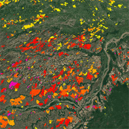
MTBS Burned Area Boundaries
The Monitoring Trends in Burn Severity (MTBS) burned area boundaries dataset contains the extent polygons of the burned areas of all currently completed MTBS fires for the continental United States, Alaska, Hawaii, and Puerto Rico. Below NBR stands for "Normalized Burn Ratio", while dNBR stands … eros fire gtac mtbs table usda -
MYD14A1.061: Aqua Thermal Anomalies & Fire Daily Global 1km
The MYD14A1 V6.1 dataset provides daily fire mask composites at 1km resolution derived from the MODIS 4- and 11-micrometer radiances. The fire detection strategy is based on absolute detection of a fire (when the fire strength is sufficient to detect), and on detection relative to … aqua daily fire global modis nasa -
MYD14A2.061: Aqua Thermal Anomalies & Fire 8-Day Global 1km

The MYD14A2 V6.1 dataset provides 8-day fire mask composites at 1km resolution. It contains the maximum value of the individual pixel classes over the compositing period. Along with the fire mask, an associated quality information layer is also provided. Documentation: User's Guide Algorithm Theoretical Basis … 8-day aqua fire global modis nasa -
Monitoring Trends in Burn Severity (MTBS) Burn Severity Images
The burn severity mosaics consist of thematic raster images of MTBS burn severity classes for all currently completed MTBS fires for the continental United States, Alaska, Hawaii and Puerto Rico. Mosaicked burn severity images are compiled annually for each year by US State and the … eros fire forest gtac landcover landsat-derived -
VJ114IMGTDL_NRT Daily Raster: VIIRS (NOAA-20) Band 375m Active Fire
NOAA-20 (JPSS-1) Visible Infrared Imaging Radiometer Suite (VIIRS) Active Fire detection product is based on the instrument's 375m nominal resolution data. Compared to other coarser resolution (≥ 1km) satellite fire detection products, the improved 375 m data provide greater response over fires of relatively small … eosdis fire firms geophysical hotspot lance -
VNP14A1.002: Thermal Anomalies/Fire Daily L3 Global 1km SIN Grid
The daily Suomi National Polar-Orbiting Partnership NASA Visible Infrared Imaging Radiometer Suite (VIIRS) Thermal Anomalies/Fire (VNP14A1) Version 1 data product provides daily information about active fires and other thermal anomalies. The VNP14A1 data product is a global, 1km gridded composite of fire pixels detected from … fire land nasa noaa surface viirs -
VNP14IMGTDL_NRT Daily Raster: VIIRS (S-NPP) Band 375m Active Fire
Suomi NPP Visible Infrared Imaging Radiometer Suite (VIIRS) Active Fire detection product is based on the instrument's 375m nominal resolution data. Compared to other coarser resolution (≥ 1km) satellite fire detection products, the improved 375 m data provide greater response over fires of relatively small … eosdis fire firms geophysical hotspot lance -
VNP64A1.002: Burned Area Monthly L4 Global 500m SIN Grid
The daily Suomi National Polar-Orbiting Partnership (Suomi NPP) NASA Visible Infrared Imaging Radiometer Suite (VIIRS) Burned Area (VNP64A1) Version 2 data product is a monthly, global gridded 500m product containing per-pixel burned area and quality information. The VNP64 burned area mapping approach employs 750m VIIRS … burn change-detection fire land nasa surface -
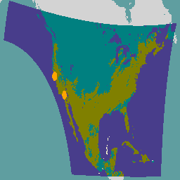
Wildfire Risk to Communities v0

This dataset depicts components of wildfire risk for all lands in the United States that: 1) are landscape-wide (i.e., measurable at every pixel across the landscape); and 2) represent in situ risk - risk at the location where the adverse effects take place on the … burn fire usda wildfire