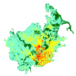
The burn severity mosaics consist of thematic raster images of MTBS burn
severity classes for all currently completed MTBS fires for the continental
United States, Alaska, Hawaii and Puerto Rico. Mosaicked burn severity
images are compiled annually for each year by US State and the continental
United States.
Monitoring Trends in Burn Severity (MTBS) is an interagency program whose goal
is to consistently map the burn severity and extent of large fires across all
lands of the United States from 1984 to present. This includes all fires 1000
acres or greater in the western United States and 500 acres or greater in the
eastern Unites States. The extent of coverage includes the continental U.S.,
Alaska, Hawaii and Puerto Rico.
The program is conducted by the U.S. Geological Survey Center for Earth
Resources Observation and Science (EROS) and the USDA Forest Service Geospatial
Technology and Applications Center (GTAC). MTBS was first enacted in 2005,
primarily to meet the information needs of the Wildland Fire Leadership Council
(WFLC). The primary objective at that time was to provide data to the WFLC for
monitoring the effectiveness of the ten-year National Fire Plan. The scope of
the program has grown since inception and provides data to a wide range of
users. These include national policy-makers such as WFLC and others who are
focused on implementing and monitoring national fire management strategies;
field management units such as national forests, parks and other federal and
tribal lands that benefit from the availability of GIS-ready maps and data;
other federal land cover mapping programs such as LANDFIRE which utilizes burn
severity data in their own efforts; and academic and agency research entities
interested in fire severity data over significant geographic and temporal
extents.
MTBS data are freely available to the public and are generated by leveraging
other national programs including the Landsat satellite program, jointly
developed and managed by the USGS and NASA. Landsat data are analyzed through a
standardized and consistent methodology, generating products at a 30 meter
resolution dating back to 1984. One of the greatest strengths of the program is
the consistency of the data products which would be impossible without the
historic Landsat archive, the largest in the world.
You can also visit the
MTBS Data Explorer
to learn more and interact with the data.
Bands
Bands
Name
Pixel Size
Description
Severity
30 meters
Burn severity layers are thematic images depicting severity as
unburned to low, low, moderate, high, and increased greenness
(increased postfire vegetation response). The layer may also have
a sixth class representing a mask for clouds, shadows, large water
bodies, or other features on the landscape that erroneously affect
the severity classification.
Severity Class Table
Value
Color
Description
0
#000000
Background
1
#006400
Unburned to Low
2
#7fffd4
Low
3
#ffff00
Moderate
4
#ff0000
High
5
#7fff00
Increased Greenness
6
#ffffff
Non-Mapping Area
Image Properties
Image Properties
Name
Type
Description
study_area
STRING
MTBS currently covers CONUS, Alaska, Puerto Rico, and Hawaii.
Possible values: CONUS, AK, PR, HI.
Terms of Use
Terms of Use
The USDA Forest Service makes no warranty, expressed or implied, including
the warranties of merchantability and fitness for a particular purpose, nor
assumes any legal liability or responsibility for the accuracy, reliability,
completeness or utility of these geospatial data, or for the improper or
incorrect use of these geospatial data. These geospatial data and related
maps or graphics are not legal documents and are not intended to be used
as such.
The data and maps may not be used to determine title, ownership, legal
descriptions or boundaries, legal jurisdiction, or restrictions that may be
in place on either public or private land. Natural hazards may or may not be
depicted on the data and maps, and land users should exercise due caution.
The data are dynamic and may change over time. The user is responsible to
verify the limitations of the geospatial data and to use the data
accordingly. These data were collected using funding from the U.S.
Government and can be used without additional permissions or fees. If you
use these data in a publication, presentation, or other research product
please use the following citation:
USDA Forest Service/US Geological Survey. Monitoring Trends in Burn Severity
Thematic Burn Severity. Salt Lake City, Utah/Sioux Falls, South Dakota
Citations
Citations:
USDA Forest Service/US Geological Survey. Monitoring Trends in Burn
Severity Thematic Burn Severity. Salt Lake City, Utah/Sioux Falls,
South Dakota
The burn severity mosaics consist of thematic raster images of MTBS burn severity classes for all currently completed MTBS fires for the continental United States, Alaska, Hawaii and Puerto Rico. Mosaicked burn severity images are compiled annually for each year by US State and the continental United States. Monitoring Trends …
[[["Easy to understand","easyToUnderstand","thumb-up"],["Solved my problem","solvedMyProblem","thumb-up"],["Other","otherUp","thumb-up"]],[["Missing the information I need","missingTheInformationINeed","thumb-down"],["Too complicated / too many steps","tooComplicatedTooManySteps","thumb-down"],["Out of date","outOfDate","thumb-down"],["Samples / code issue","samplesCodeIssue","thumb-down"],["Other","otherDown","thumb-down"]],[],[[["\u003cp\u003eThe dataset provides annual burn severity mosaics for the continental US, Alaska, Hawaii, and Puerto Rico from 1984 to 2021.\u003c/p\u003e\n"],["\u003cp\u003eBurn severity is classified into six categories: unburned to low, low, moderate, high, increased greenness, and non-mapping area.\u003c/p\u003e\n"],["\u003cp\u003eThe dataset is a product of the Monitoring Trends in Burn Severity (MTBS) program, a joint effort by the USGS and USFS.\u003c/p\u003e\n"],["\u003cp\u003eIt utilizes Landsat data to map the burn severity and extent of large fires (greater than 1000 acres in the west and 500 acres in the east).\u003c/p\u003e\n"],["\u003cp\u003eThe data is freely available for public use and can be accessed through the Earth Engine platform.\u003c/p\u003e\n"]]],[],null,["# Monitoring Trends in Burn Severity (MTBS) Burn Severity Images\n\nDataset Availability\n: 1984-01-01T00:00:00Z--2024-12-31T00:00:00Z\n\nDataset Provider\n:\n\n\n [Monitoring Trends in Burn Severity (MTBS)](https://mtbs.gov)\n\n\n [USDA Forest Service (USFS) Geospatial Technology and Applications Center (GTAC)](https://www.fs.usda.gov/about-agency/gtac)\n\n\n [United States Geological Survey (USGS) Earth Resources Observation and Science (EROS) Center](https://www.usgs.gov/centers/eros)\n\nTags\n:\n[eros](/earth-engine/datasets/tags/eros) [fire](/earth-engine/datasets/tags/fire) [forest](/earth-engine/datasets/tags/forest) [gtac](/earth-engine/datasets/tags/gtac) [landcover](/earth-engine/datasets/tags/landcover) [landsat-derived](/earth-engine/datasets/tags/landsat-derived) [mtbs](/earth-engine/datasets/tags/mtbs) [redcastle-resources](/earth-engine/datasets/tags/redcastle-resources) [usda](/earth-engine/datasets/tags/usda) [usfs](/earth-engine/datasets/tags/usfs) [usgs](/earth-engine/datasets/tags/usgs) \n\n#### Description\n\nThe burn severity mosaics consist of thematic raster images of MTBS burn\nseverity classes for all currently completed MTBS fires for the continental\nUnited States, Alaska, Hawaii and Puerto Rico. Mosaicked burn severity\nimages are compiled annually for each year by US State and the continental\nUnited States.\nMonitoring Trends in Burn Severity (MTBS) is an interagency program whose goal\nis to consistently map the burn severity and extent of large fires across all\nlands of the United States from 1984 to present. This includes all fires 1000\nacres or greater in the western United States and 500 acres or greater in the\neastern Unites States. The extent of coverage includes the continental U.S.,\nAlaska, Hawaii and Puerto Rico.\n\nThe program is conducted by the U.S. Geological Survey Center for Earth\nResources Observation and Science (EROS) and the USDA Forest Service Geospatial\nTechnology and Applications Center (GTAC). MTBS was first enacted in 2005,\nprimarily to meet the information needs of the Wildland Fire Leadership Council\n(WFLC). The primary objective at that time was to provide data to the WFLC for\nmonitoring the effectiveness of the ten-year National Fire Plan. The scope of\nthe program has grown since inception and provides data to a wide range of\nusers. These include national policy-makers such as WFLC and others who are\nfocused on implementing and monitoring national fire management strategies;\nfield management units such as national forests, parks and other federal and\ntribal lands that benefit from the availability of GIS-ready maps and data;\nother federal land cover mapping programs such as LANDFIRE which utilizes burn\nseverity data in their own efforts; and academic and agency research entities\ninterested in fire severity data over significant geographic and temporal\nextents.\n\nMTBS data are freely available to the public and are generated by leveraging\nother national programs including the Landsat satellite program, jointly\ndeveloped and managed by the USGS and NASA. Landsat data are analyzed through a\nstandardized and consistent methodology, generating products at a 30 meter\nresolution dating back to 1984. One of the greatest strengths of the program is\nthe consistency of the data products which would be impossible without the\nhistoric Landsat archive, the largest in the world.\n\nYou can visit the [MTBS Project Website](https://www.mtbs.gov) for more\ninformation.\n\nYou can also visit the\n[MTBS Data Explorer](https://apps.fs.usda.gov/lcms-viewer/mtbs.html)\nto learn more and interact with the data.\n\n### Bands\n\n**Bands**\n\n| Name | Pixel Size | Description |\n|------------|------------|-------------------------------------------------------------------------------------------------------------------------------------------------------------------------------------------------------------------------------------------------------------------------------------------------------------------------------------------------------------------|\n| `Severity` | 30 meters | Burn severity layers are thematic images depicting severity as unburned to low, low, moderate, high, and increased greenness (increased postfire vegetation response). The layer may also have a sixth class representing a mask for clouds, shadows, large water bodies, or other features on the landscape that erroneously affect the severity classification. |\n\n**Severity Class Table**\n\n| Value | Color | Description |\n|-------|---------|---------------------|\n| 0 | #000000 | Background |\n| 1 | #006400 | Unburned to Low |\n| 2 | #7fffd4 | Low |\n| 3 | #ffff00 | Moderate |\n| 4 | #ff0000 | High |\n| 5 | #7fff00 | Increased Greenness |\n| 6 | #ffffff | Non-Mapping Area |\n\n### Image Properties\n\n**Image Properties**\n\n| Name | Type | Description |\n|------------|--------|---------------------------------------------------------------------------------------------------|\n| study_area | STRING | MTBS currently covers CONUS, Alaska, Puerto Rico, and Hawaii. Possible values: CONUS, AK, PR, HI. |\n\n### Terms of Use\n\n**Terms of Use**\n\nThe USDA Forest Service makes no warranty, expressed or implied, including\nthe warranties of merchantability and fitness for a particular purpose, nor\nassumes any legal liability or responsibility for the accuracy, reliability,\ncompleteness or utility of these geospatial data, or for the improper or\nincorrect use of these geospatial data. These geospatial data and related\nmaps or graphics are not legal documents and are not intended to be used\nas such.\n\nThe data and maps may not be used to determine title, ownership, legal\ndescriptions or boundaries, legal jurisdiction, or restrictions that may be\nin place on either public or private land. Natural hazards may or may not be\ndepicted on the data and maps, and land users should exercise due caution.\nThe data are dynamic and may change over time. The user is responsible to\nverify the limitations of the geospatial data and to use the data\naccordingly. These data were collected using funding from the U.S.\nGovernment and can be used without additional permissions or fees. If you\nuse these data in a publication, presentation, or other research product\nplease use the following citation:\nUSDA Forest Service/US Geological Survey. Monitoring Trends in Burn Severity\nThematic Burn Severity. Salt Lake City, Utah/Sioux Falls, South Dakota\n\n### Citations\n\nCitations:\n\n- USDA Forest Service/US Geological Survey. Monitoring Trends in Burn\n Severity Thematic Burn Severity. Salt Lake City, Utah/Sioux Falls,\n South Dakota\n\n### Explore with Earth Engine\n\n| **Important:** Earth Engine is a platform for petabyte-scale scientific analysis and visualization of geospatial datasets, both for public benefit and for business and government users. Earth Engine is free to use for research, education, and nonprofit use. To get started, please [register for Earth Engine access.](https://console.cloud.google.com/earth-engine)\n\n### Code Editor (JavaScript)\n\n```javascript\nvar dataset = ee.ImageCollection('USFS/GTAC/MTBS/annual_burn_severity_mosaics/v1');\n\nvar visualization = {\n bands: ['Severity'],\n min: 0,\n max: 6,\n palette:\n ['000000', '006400', '7fffd4', 'ffff00', 'ff0000', '7fff00', 'ffffff']\n};\n\nMap.setCenter(-95.712891, 37.09024, 5);\n\nMap.addLayer(dataset, visualization, 'Severity');\n```\n[Open in Code Editor](https://code.earthengine.google.com/?scriptPath=Examples:Datasets/USFS/USFS_GTAC_MTBS_annual_burn_severity_mosaics_v1) \n[Monitoring Trends in Burn Severity (MTBS) Burn Severity Images](/earth-engine/datasets/catalog/USFS_GTAC_MTBS_annual_burn_severity_mosaics_v1) \nThe burn severity mosaics consist of thematic raster images of MTBS burn severity classes for all currently completed MTBS fires for the continental United States, Alaska, Hawaii and Puerto Rico. Mosaicked burn severity images are compiled annually for each year by US State and the continental United States. Monitoring Trends ... \nUSFS/GTAC/MTBS/annual_burn_severity_mosaics/v1, eros,fire,forest,gtac,landcover,landsat-derived,mtbs,redcastle-resources,usda,usfs,usgs \n1984-01-01T00:00:00Z/2024-12-31T00:00:00Z \n20.38379 -135.286387 52.459364 -56.446306 \nGoogle Earth Engine \nhttps://developers.google.com/earth-engine/datasets\n\n- [](https://doi.org/https://mtbs.gov)\n- [](https://doi.org/https://www.fs.usda.gov/about-agency/gtac)\n- [](https://doi.org/https://www.usgs.gov/centers/eros)\n- [](https://doi.org/https://developers.google.com/earth-engine/datasets/catalog/USFS_GTAC_MTBS_annual_burn_severity_mosaics_v1)"]]