Page Summary
-
The Earth Engine version of the Fire Information for Resource Management System (FIRMS) dataset contains near real-time active fire locations processed by LANCE using the standard MODIS MOD14/MYD14 product.
-
The VIIRS (NOAA-20) Band 375m Active Fire detection product is based on 375m nominal resolution data, offering improved response to relatively small fires compared to coarser resolution products.
-
The VIIRS (S-NPP) Band 375m Active Fire detection product is based on 375m nominal resolution data, providing better detection of relatively small fires compared to coarser resolution products.
-
FIRMS: Fire Information for Resource Management System
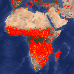
The Earth Engine version of the Fire Information for Resource Management System (FIRMS) dataset contains the LANCE fire detection product in rasterized form. The near real-time (NRT) active fire locations are processed by LANCE using the standard MODIS MOD14/MYD14 Fire and Thermal Anomalies product. Each … eosdis fire firms geophysical hotspot lance -
VJ114IMGTDL_NRT Daily Raster: VIIRS (NOAA-20) Band 375m Active Fire
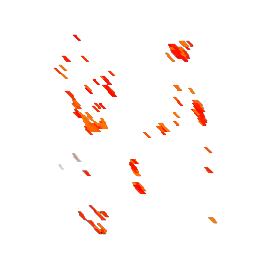
NOAA-20 (JPSS-1) Visible Infrared Imaging Radiometer Suite (VIIRS) Active Fire detection product is based on the instrument's 375m nominal resolution data. Compared to other coarser resolution (≥ 1km) satellite fire detection products, the improved 375 m data provide greater response over fires of relatively small … eosdis fire firms geophysical hotspot lance -
VNP14IMGTDL_NRT Daily Raster: VIIRS (S-NPP) Band 375m Active Fire
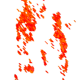
Suomi NPP Visible Infrared Imaging Radiometer Suite (VIIRS) Active Fire detection product is based on the instrument's 375m nominal resolution data. Compared to other coarser resolution (≥ 1km) satellite fire detection products, the improved 375 m data provide greater response over fires of relatively small … eosdis fire firms geophysical hotspot lance