Page Summary
-
LANDFIRE is a collaborative program providing historical fire regime, interval, and vegetation condition data to support fire and landscape management planning.
-
The Mean Fire Return Interval (MFRI) layer within LANDFIRE quantifies the average period between fires under the presumed historical fire regime.
-
MFRI data is derived from vegetation and disturbance dynamics models and is linked to Biophysical Settings (BPS) layer attributes.
-
LANDFIRE Fire datasets, including MFRI, are public domain with no usage restrictions, though modifications should be clearly indicated.
- Dataset Availability
- 2010-01-01T00:00:00Z–2010-12-31T00:00:00Z
- Dataset Producer
- U.S. Department of Agriculture's (USDA), U.S. Forest Service (USFS), U.S. Department of the Interior's Geological Survey (USGS), and The Nature Conservancy.
- Tags
Description
LANDFIRE (LF), Landscape Fire and Resource Management Planning Tools, is a shared program between the wildland fire management programs of the U.S. Department of Agriculture's Forest Service, U.S. Department of the Interior's Geological Survey, and The Nature Conservancy.
Landfire (LF) Historical fire regimes, intervals, and vegetation conditions are mapped using the Vegetation Dynamics Development Tool (VDDT). These data support fire and landscape management planning goals in the National Cohesive Wildland Fire Management Strategy, the Federal Wildland Fire Management Policy, and the Healthy Forests Restoration Act.
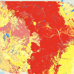
The Mean Fire Return Interval (MFRI) layer quantifies the average period between fires under the presumed historical fire regime. MFRI is intended to describe one component of historical fire regime characteristics in the context of the broader historical time period represented by the LANDFIRE (LF) Biophysical Settings (BPS) layer and BPS Model documentation. MFRI is derived from the vegetation and disturbance dynamics model VDDT (Vegetation Dynamics Development Tool) (LF 1.0.0 CONUS only used the vegetation and disturbance dynamics model LANDSUM). This layer is created by linking the BpS Group attribute in the BpS layer with the Refresh Model Tracker (RMT) data and assigning the MFRI attribute. This geospatial product should display a reasonable approximation of MFRI, as documented in the RMT. MFRI is used in landscape assessments.
The LANDIFRE Fire datasets include:
- Fire Regime Groups (FRG) is intended to characterize presumed historical fire regimes within landscapes based on interactions between vegetation dynamics, fire spread, fire effects, and spatial context
- Mean Fire Return Interval (MFRI) quantifies the average period between fires under the presumed historical fire regime
- Percent of Low-severity Fire (PLS) image quantifies the amount of low-severity fires relative to mixed- and replacement-severity fires under the presumed historical fire regime and is defined as less than 25 percent average top-kill within a typical fire perimeter for a given vegetation type
- Percent of Mixed-severity Fire (PMS) layer quantifies the amount of mixed-severity fires relative to low- and replacement-severity fires under the presumed historical fire regime, and is defined as between 25 and 75 percent average top-kill within a typical fire perimeter for a given vegetation type
- Percent of Replacement-severity Fire (PRS) layer quantifies the amount of replacement-severity fires relative to low- and mixed-severity fires under the presumed historical fire regime, and is defined as greater than 75 percent average top-kill within a typical fire perimeter for a given vegetation type
- Succession Classes (SClass) layer characterizes current vegetation conditions with respect to the vegetation species composition, cover, and height ranges of successional states that occur within each biophysical setting
- Vegetation Condition Class (VCC) represents a simple categorization of the associated Vegetation Departure (VDEP) layer and indicates the general level to which current vegetation is different from the simulated historical vegetation reference conditions
- Vegetation Departure (VDep) indicates how different current vegetation on a landscape is from estimated historical conditions. VDep is based on changes to species composition, structural stage, and canopy closure.
Bands
Bands
Pixel size: 30 meters (all bands)
| Name | Pixel Size | Description |
|---|---|---|
MFRI |
30 meters | Mean Fire Return Interval |
MFRI Class Table
| Value | Color | Description |
|---|---|---|
| 1 | #0b0080 | 0-5 Years |
| 2 | #3800a1 | 6-10 Years |
| 3 | #470087 | 11-15 Years |
| 4 | #9300b0 | 16-20 Years |
| 5 | #bf00ac | 21-25 Years |
| 6 | #cf008a | 26-30 Years |
| 7 | #de0059 | 31-35 Years |
| 8 | #f00028 | 36-40 Years |
| 9 | #e60000 | 41-45 Years |
| 10 | #ff4d00 | 46-50 Years |
| 11 | #ff8400 | 51-60 Years |
| 12 | #ffbf00 | 61-70 Years |
| 13 | #fffb00 | 71-80 Years |
| 14 | #fff642 | 81-90 Years |
| 15 | #fff782 | 91-100 Years |
| 16 | #fffac4 | 101-125 Years |
| 17 | #d4de8a | 126-150 Years |
| 18 | #9dbf58 | 151-200 Years |
| 19 | #64a132 | 201-300 Years |
| 20 | #4b8c23 | 301-500 Years |
| 21 | #146600 | 501-1000 Years |
| 22 | #004700 |
|
| 111 | #0000ff | Water |
| 112 | #c8ffff | Snow / Ice |
| 131 | #4e4e4e | Barren |
| 132 | #b2b2b2 | Sparsely Vegetated |
| 133 | #e1e1e1 | Indeterminate Fire Regime Characteristics |
Image Properties
Image Properties
| Name | Type | Description |
|---|---|---|
| MFRI_classes | DOUBLE | Class values of the mean fire return interval. |
| MFRI_names | STRING | Descriptive names of the mean fire return interval. |
Terms of Use
Terms of Use
LANDFIRE data are public domain data with no use restrictions, though if modifications or derivatives of the product(s) are created, then please add some descriptive modifier to the data set to avoid confusion.
Citations
The suggested way to cite LANDFIRE products is specific to each product, so the model for citation is provided, with an example for a particular product. Producer. Year released. Product xxxxx:
- Individual model name.
- BpS Models and Descriptions, Online. LANDFIRE. Washington, DC. U.S. Department of Agriculture, Forest Service
- U.S. Department of the Interior; U.S. Geological Survey; Arlington, VA
- The Nature Conservancy (Producers). Available- URL. Access date.
Example Citation: LANDFIRE Biophysical Settings. 2018. Biophysical setting 14420: South Texas sand sheet grassland. In: LANDFIRE Biophysical Setting Model: Map zone 36, [Online]. In: BpS Models and Descriptions. In: LANDFIRE. Washington, DC: U.S. Department of Agriculture, Forest Service; U.S. Department of the Interior; U.S. Geological Survey; Arlington, VA: The Nature Conservancy (Producers). Available: https://www.landfire.gov/bps-models.php [2018, June 27]. Additional guidance on citation of LANDFIRE products can be found here
Explore with Earth Engine
Code Editor (JavaScript)
var dataset = ee.ImageCollection('LANDFIRE/Fire/MFRI/v1_2_0');

var visualization = {
  bands: ['MFRI'],
};

Map.setCenter(-121.671, 40.699, 5);

Map.addLayer(dataset, visualization, 'MFRI');