Koleksiyonlar ile düzeninizi koruyun
İçeriği tercihlerinize göre kaydedin ve kategorilere ayırın.
Maps JavaScript API, haritanın iki farklı uygulamasını sunar: raster ve vektör. Raster harita varsayılan olarak yüklenir ve haritayı, Google Haritalar Platformu sunucu tarafında oluşturulan, ardından web uygulamanıza sunulan piksel tabanlı raster görüntü döşemeleri ızgarası olarak yükler. Vektör harita, yükleme sırasında istemci tarafında WebGL kullanılarak çizilen vektör tabanlı döşemelerden oluşur. WebGL, tarayıcının kullanıcının cihazındaki GPU'ya erişerek 2D ve 3D grafikler oluşturmasına olanak tanıyan bir web teknolojisidir. Vektör harita türü, daha iyi görsel doğruluk ve haritada eğimi ve yönü kontrol etme olanağı sağladığı için en iyi kullanıcı deneyimi için önerilir.
Vektör harita özellikleri hakkında daha fazla bilgi edinin.
renderingType map seçeneğini belirterek veya seçeneği ilişkili bir harita kimliğinde ayarlayarak haritanın oluşturma türünü ayarlayın. renderingType seçeneği, harita kimliği yapılandırılarak yapılan tüm oluşturma türü ayarlarını geçersiz kılar.
renderingType seçeneğini belirtin.
Haritanız için raster veya vektör oluşturma türünü belirtmek üzere renderingType seçeneğini kullanın (harita kimliği gerekmez). div öğesi ve JavaScript kullanılarak yüklenen haritalarda varsayılan oluşturma türü google.maps.RenderingType.RASTER'dir. renderingType seçeneğini ayarlamak için aşağıdaki adımları uygulayın:
RenderingType kitaplığını yükleyin. Bu işlem, Maps kitaplığı yüklenirken yapılabilir:
Vektör harita oluşturma türü ayarlandığında, gerekli özelliklerin seçeneklerini ayarlamanız gerekir.
Eğme özelliğini etkinleştirmek için tiltInteractionEnabled harita seçeneğini true olarak ayarlayın veya map.setTiltInteractionEnabled(true)'ı arayın.
Kaydırmayı etkinleştirmek için headingInteractionEnabled harita seçeneğini true olarak ayarlayın veya map.setHeadingInteractionEnabled(true) işlevini çağırın.
<gmp-map> öğesi kullanılarak yüklenen haritalarda varsayılan oluşturma türü google.maps.RenderingType.VECTOR'dir. Bu türde eğme ve yön kontrolü etkindir. Oluşturma türünü <gmp-map> öğesini kullanarak ayarlamak için rendering-type özelliğini kullanın.
Oluşturma türünü ayarlamak için harita kimliği kullanma
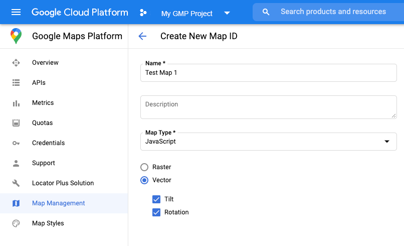
Ayrıca, harita kimliği kullanarak oluşturma türünü de belirtebilirsiniz. Yeni bir harita kimliği oluşturmak için Bulut tabanlı harita stilini kullanma - Harita kimliği edinme bölümündeki adımları uygulayın.
Harita türünü JavaScript olarak ayarladığınızdan ve bir seçenek (Vektör veya Raster) belirlediğinizden emin olun. Haritada eğme ve döndürme özelliklerini etkinleştirmek için Eğme ve Döndürme'yi işaretleyin. Bu sayede, bu değerleri programatik olarak ayarlayabilir ve kullanıcıların eğimi ve başlığı doğrudan harita üzerinde ayarlamasına olanak tanıyabilirsiniz. Eğme veya yönün kullanılması uygulamanızı olumsuz etkileyecekse kullanıcıların eğme ve döndürme ayarlarını yapamaması için Eğme ve Döndürme seçeneklerinin işaretini kaldırın.
Ardından, harita başlatma kodunuzu oluşturduğunuz harita kimliğiyle güncelleyin. Harita kimliklerinizi Harita Yönetimi sayfasında bulabilirsiniz. Haritayı şu şekilde mapId özelliğini kullanarak oluşturduğunuzda bir harita kimliği sağlayın:
[[["Anlaması kolay","easyToUnderstand","thumb-up"],["Sorunumu çözdü","solvedMyProblem","thumb-up"],["Diğer","otherUp","thumb-up"]],[["İhtiyacım olan bilgiler yok","missingTheInformationINeed","thumb-down"],["Çok karmaşık / çok fazla adım var","tooComplicatedTooManySteps","thumb-down"],["Güncel değil","outOfDate","thumb-down"],["Çeviri sorunu","translationIssue","thumb-down"],["Örnek veya kod sorunu","samplesCodeIssue","thumb-down"],["Diğer","otherDown","thumb-down"]],["Son güncelleme tarihi: 2025-08-27 UTC."],[[["\u003cp\u003eThe Maps JavaScript API offers two map types: raster (default) and vector (recommended for enhanced user experience with tilt and heading control).\u003c/p\u003e\n"],["\u003cp\u003eYou can set the rendering type using the \u003ccode\u003erenderingType\u003c/code\u003e map option or by associating a map ID with specific rendering settings.\u003c/p\u003e\n"],["\u003cp\u003eVector maps provide better visual quality and allow for tilt and heading manipulation, requiring enabling specific interactions for these features.\u003c/p\u003e\n"],["\u003cp\u003eMap IDs offer pre-configured rendering types and can be created and managed through the Cloud console, enabling customization without code changes.\u003c/p\u003e\n"],["\u003cp\u003eUsing a map ID and API key from the same Google Cloud project is recommended for optimal integration and management.\u003c/p\u003e\n"]]],[],null,["# Rendering type (raster and vector)\n\nThe Maps JavaScript API offers two different implementations of the map: raster\nand vector. The raster map is loaded by default, and loads the map as a grid of\npixel-based raster image tiles, which are generated by Google Maps Platform\nserver-side, then served to your web app. The vector map is a composed of\nvector-based tiles, which are drawn at load time on the client-side using\nWebGL, a web technology that allows the browser to access the GPU on the user's\ndevice to render 2D and 3D graphics. The vector map type is recommended for the\nbest user experience, as it provides improved visual fidelity as well as the\nability to control tilt and heading on the map.\n[Learn more about vector map features.](/maps/documentation/javascript/vector-map)\n\nSet the rendering type for a map either by specifying the `renderingType` map\noption, or by setting the option on an associated map ID. The `renderingType`\noption overrides any rendering type settings made by configuring a map ID.\n\nSpecify the `renderingType` option\n----------------------------------\n\nUse the `renderingType` option to specify either the raster or vector\nrendering type for your map (no map ID required). For maps loaded using a `div`\nelement and JavaScript, the default rendering type is\n`google.maps.RenderingType.RASTER`. Take these steps to set the `renderingType`\noption:\n\n1. Load the `RenderingType` library; this can be done when loading the Maps\n library:\n\n const { Map, RenderingType } = await google.maps.importLibrary(\"maps\");\n\n2. When initializing the map, use the `renderingType` option to specify either\n `RenderingType.VECTOR` or `RenderingType.RASTER`:\n\n map = new Map(\n document.getElementById('map'),\n {\n zoom: 4,\n center: position,\n renderingType: RenderingType.VECTOR,\n }\n );\n\nWhen the vector map rendering type is set, you must set the options for the\nneeded features.\n\n- To enable tilt, set the `tiltInteractionEnabled` map option to `true` or call `map.setTiltInteractionEnabled(true)`.\n- To enable panning, set the `headingInteractionEnabled` map option to `true` or call `map.setHeadingInteractionEnabled(true)`.\n\nFor maps loaded using the `\u003cgmp-map\u003e` element, the default rendering type is\n`google.maps.RenderingType.VECTOR`, with tilt and heading control enabled. To\nset the rendering type by using the `\u003cgmp-map\u003e` element, use the\n`rendering-type` attribute.\n\nUse a map ID to set rendering type\n----------------------------------\n\nYou can also specify the rendering type by using a map ID. To create a new map\nID, follow the steps in [Using Cloud-based Map Styling - Get a map ID](/maps/documentation/javascript/styling#creating-map-ids).\nBe sure to set the Map type to **JavaScript** , and select an option (**Vector**\nor **Raster** ). Check **Tilt** and **Rotation** to enable tilt and rotation\non the map. Doing so will allow you to programmatically adjust these values, and\nalso lets users adjust tilt and heading directly on the map. If the use of tilt\nor heading will adversely affect your app, leave **Tilt** and **Rotation** un-\nchecked so users will not be able to adjust tilt and rotation.\n\nNext, update your map initialization code with the map ID you created. You can\nfind your map IDs on the\n[Maps\nManagement](https://console.cloud.google.com/google/maps-apis/studio/maps) page. Provide a map ID when you instantiate the map using the\n`mapId` property as shown here: \n\n```javascript\nmap = new google.maps.Map(document.getElementById('map'), {\n center: {lat: -34.397, lng: 150.644},\n zoom: 8,\n mapId: '\u003cvar translate=\"no\"\u003eMAP_ID\u003c/var\u003e'\n});\n```\n| **Important:** It is recommended to associate your map ID and API key with the same Google Cloud console project."]]