Page Summary
-
Earth Engine defaults to nearest neighbor resampling during reprojection but allows changing this with
resample()orreduceResolution(). -
The
resample()method forces the next reprojection to use specified resampling methods like 'bilinear' or 'bicubic'. -
The
reduceResolution()method is used to aggregate smaller pixels to larger ones during reprojection, useful for comparing datasets at different scales. -
When using
reduceResolution(), input pixel weights for aggregation are typically based on the fraction of the output pixel area they cover.
As noted in the Projections doc, Earth Engine performs nearest
neighbor resampling by default during reprojection. You can change this behavior
with the resample() or reduceResolution() methods. Specifically, when one of
these methods is applied to an input image, any required reprojection of the
input will be done using the indicated resampling or aggregation method.
Resampling
resample() causes the indicated resampling method ('bilinear' or
'bicubic') to be used at the next reprojection. Since inputs are requested in
the output projection, an implicit reprojection may happen before any other
operation on the input. For this reason, call resample() directly on the input
image. Consider the following simple example:
Code Editor (JavaScript)
// Load a Landsat image over San Francisco, California, UAS.
var landsat = ee.Image('LANDSAT/LC08/C02/T1_TOA/LC08_044034_20160323');

// Set display and visualization parameters.
Map.setCenter(-122.37383, 37.6193, 15);
var visParams = {bands: ['B4', 'B3', 'B2'], max: 0.3};

// Display the Landsat image using the default nearest neighbor resampling.
// when reprojecting to Mercator for the Code Editor map.
Map.addLayer(landsat, visParams, 'original image');

// Force the next reprojection on this image to use bicubic resampling.
var resampled = landsat.resample('bicubic');

// Display the Landsat image using bicubic resampling.
Map.addLayer(resampled, visParams, 'resampled');
import ee
import geemap.core as geemap
Colab (Python)
# Load a Landsat image over San Francisco, California, UAS.
landsat = ee.Image('LANDSAT/LC08/C02/T1_TOA/LC08_044034_20160323')

# Set display and visualization parameters.
m = geemap.Map()
m.set_center(-122.37383, 37.6193, 15)
vis_params = {'bands': ['B4', 'B3', 'B2'], 'max': 0.3}

# Display the Landsat image using the default nearest neighbor resampling.
# when reprojecting to Mercator for the Code Editor map.
m.add_layer(landsat, vis_params, 'original image')

# Force the next reprojection on this image to use bicubic resampling.
resampled = landsat.resample('bicubic')

# Display the Landsat image using bicubic resampling.
m.add_layer(resampled, vis_params, 'resampled')
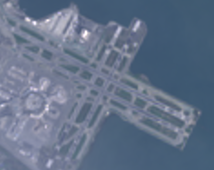
Note that the 'bicubic' resampling results in the output pixels appearing
smooth relative to the original image (Figure 1).

The order of operations for this code sample is diagrammed in Figure 2. Specifically, the implicit reprojection to the maps mercator projection takes place with the resampling method specified on the input image.
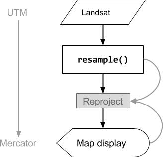
Figure 2. Flow chart of operations when resample() is called on the input
image prior to display in the Code Editor. Curved lines indicate the flow of
information to the reprojection: specifically, the output projection, scale and
resampling method to use.
Reduce Resolution
Suppose that instead of resampling during reprojection, your goal is to
aggregate pixels to larger pixels in a different projection. This is useful when
comparing image datasets at different scales, for example 30-meter pixels from a
Landsat-based product to coarse pixels (higher scale) from a MODIS-based
product. You can control this aggregation process with the reduceResolution()
method. As with resample(), call reduceResolution() on the input, in order
to affect the next reprojection of the image. The following example uses
reduceResolution() to compare forest cover data at 30-meters resolution to a
vegetation index at 500-meters resolution:
Code Editor (JavaScript)
// Load a MODIS EVI image.
var modis = ee.Image(ee.ImageCollection('MODIS/061/MOD13A1').first())
    .select('EVI');

// Display the EVI image near La Honda, California.
Map.setCenter(-122.3616, 37.5331, 12);
Map.addLayer(modis, {min: 2000, max: 5000}, 'MODIS EVI');

// Get information about the MODIS projection.
var modisProjection = modis.projection();
print('MODIS projection:', modisProjection);

// Load and display forest cover data at 30 meters resolution.
var forest = ee.Image('UMD/hansen/global_forest_change_2023_v1_11')
    .select('treecover2000');
Map.addLayer(forest, {max: 80}, 'forest cover 30 m');

// Get the forest cover data at MODIS scale and projection.
var forestMean = forest
    // Force the next reprojection to aggregate instead of resampling.
    .reduceResolution({
      reducer: ee.Reducer.mean(),
      maxPixels: 1024
    })
    // Request the data at the scale and projection of the MODIS image.
    .reproject({
      crs: modisProjection
    });

// Display the aggregated, reprojected forest cover data.
Map.addLayer(forestMean, {max: 80}, 'forest cover at MODIS scale');
import ee
import geemap.core as geemap
Colab (Python)
# Load a MODIS EVI image.
modis = ee.Image(ee.ImageCollection('MODIS/006/MOD13A1').first()).select('EVI')

# Display the EVI image near La Honda, California.
m.set_center(-122.3616, 37.5331, 12)
m.add_layer(modis, {'min': 2000, 'max': 5000}, 'MODIS EVI')

# Get information about the MODIS projection.
modis_projection = modis.projection()
display('MODIS projection:', modis_projection)

# Load and display forest cover data at 30 meters resolution.
forest = ee.Image('UMD/hansen/global_forest_change_2015').select(
    'treecover2000'
)
m.add_layer(forest, {'max': 80}, 'forest cover 30 m')

# Get the forest cover data at MODIS scale and projection.
forest_mean = (
    forest
    # Force the next reprojection to aggregate instead of resampling.
    .reduceResolution(reducer=ee.Reducer.mean(), maxPixels=1024)
    # Request the data at the scale and projection of the MODIS image.
    .reproject(crs=modis_projection)
)

# Display the aggregated, reprojected forest cover data.
m.add_layer(forest_mean, {'max': 80}, 'forest cover at MODIS scale')
In this example, note that the output projection is explicitly set with
reproject(). During the reprojection to the MODIS
sinusoidal projection, rather than resampling, the smaller pixels are aggregated
with the specified reducer (ee.Reducer.mean() in the example). This sequence
of operations is illustrated in Figure 3. Although this example uses
reproject() to help visualize the effect of reduceResolution(), most scripts
don't need to explicitly reproject; see the warning
here.
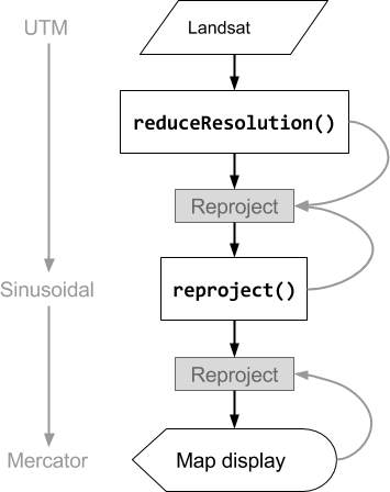
Figure 3. Flow chart of operations when reduceResolution() is called on an
input image prior to reproject(). Curved lines indicate the flow of
information to the reprojection: specifically, the output projection, scale and
pixel aggregation method to use.
Pixel weights for ReduceResolution
The weights of pixels used during the reduceResolution() aggregation process
are based on the overlap between the smaller pixels being aggregated and the
larger pixels specified by the output projection. This is illustrated in Figure
4.
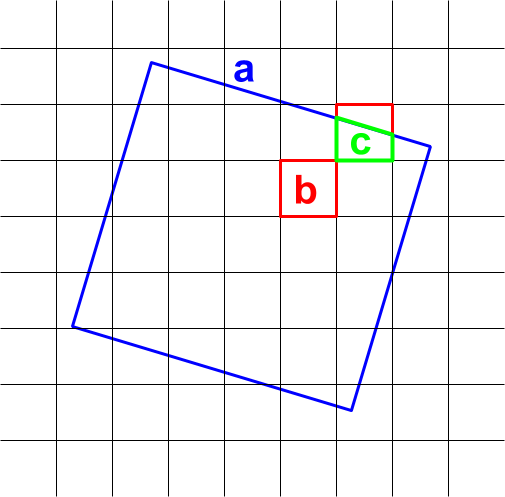
Figure 4. Input pixels (black) and output pixel (blue) for
reduceResolution().
The default behavior is that input pixel weights are computed as the fraction of
the output pixel area covered by the input pixel. In the diagram, the output
pixel has area a, the weight of the input pixel with intersection area b is
computed as b/a and the weight of the input pixel with intersection area c
is computed as c/a. This behavior can result in unexpected results when using
a reducer other than the mean reducer. For example, to compute forested area per
pixel, use the mean reducer to compute the fraction of a pixel covered, then
multiply by area (instead of computing areas in the smaller pixels then adding
them up with the sum reducer):
Code Editor (JavaScript)
// Compute forest area per MODIS pixel.
var forestArea = forest.gt(0)
    // Force the next reprojection to aggregate instead of resampling.
    .reduceResolution({
      reducer: ee.Reducer.mean(),
      maxPixels: 1024
    })
    // The reduce resolution returns the fraction of the MODIS pixel
    // that's covered by 30 meter forest pixels.  Convert to area
    // after the reduceResolution() call.
    .multiply(ee.Image.pixelArea())
    // Request the data at the scale and projection of the MODIS image.
    .reproject({
      crs: modisProjection
    });
Map.addLayer(forestArea, {max: 500 * 500}, 'forested area at MODIS scale');
import ee
import geemap.core as geemap
Colab (Python)
# Compute forest area per MODIS pixel.
forest_area = (
    forest.gt(0)
    # Force the next reprojection to aggregate instead of resampling.
    .reduceResolution(reducer=ee.Reducer.mean(), maxPixels=1024)
    # The reduce resolution returns the fraction of the MODIS pixel
    # that's covered by 30 meter forest pixels.  Convert to area
    # after the reduceResolution() call.
    .multiply(ee.Image.pixelArea())
    # Request the data at the scale and projection of the MODIS image.
    .reproject(crs=modis_projection)
)
m.add_layer(forest_area, {'max': 500 * 500}, 'forested area at MODIS scale')
m