-
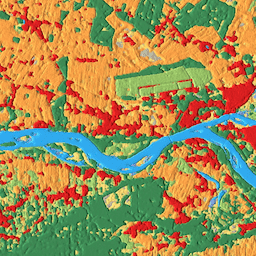
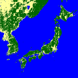
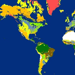
CSP gHM: Global Human Modification
Set data Modifikasi Manusia Global (gHM) memberikan ukuran kumulatif modifikasi manusia terhadap lahan terestrial secara global pada resolusi 1 kilometer persegi. Nilai gHM berkisar dari 0,0-1,0 dan dihitung dengan memperkirakan proporsi lokasi (piksel) tertentu yang dimodifikasi, perkiraan intensitas … csp fragmentation human-modification landcover landscape-gradient population -
Inventaris Tanaman Tahunan AAFC Kanada

Mulai tahun 2009, Tim Pengamatan Bumi dari Cabang Ilmu Pengetahuan dan Teknologi (STB) di Agriculture and Agri-Food Canada (AAFC) memulai proses pembuatan peta digital jenis tanaman tahunan. Berfokus pada Provinsi Prairie pada tahun 2009 dan 2010, metodologi berbasis Pohon Keputusan (DT) … agriculture canada crop landcover -
Copernicus CORINE Land Cover
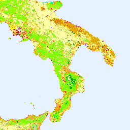
Inventaris CORINE (coordination of information on the environment) Land Cover (CLC) dimulai pada tahun 1985 untuk menstandardisasi pengumpulan data tentang lahan di Eropa guna mendukung pengembangan kebijakan lingkungan. Project ini dikoordinasikan oleh European Environment Agency (EEA) dalam kerangka kerja Uni Eropa … copernicus eea esa eu landcover landuse-landcover -
Lapisan Tutupan Lahan Global Copernicus: CGLS-LC100 Collection 3
Copernicus Global Land Service (CGLS) ditetapkan sebagai komponen layanan Land untuk mengoperasikan komponen layanan serbaguna yang menyediakan serangkaian produk bio-geofisika tentang status dan evolusi permukaan tanah dalam skala global. Peta Tutupan Lahan Dinamis di … copernicus eea esa eu landcover landuse-landcover -
Peta Tutupan Lahan BNETD 2020 Côte d'Ivoire

Peta Tutupan Lahan BNETD 2020 Côte d'Ivoire dibuat oleh Pemerintah Côte d'Ivoire melalui institusi nasional, Center for Geographic Information and Digital dari National Study Office Techniques and Development (BNETD-CIGN), dengan dukungan teknis dan keuangan dari Uni Eropa. Metodologi … klasifikasi deforestasi hutan daratan penggunaan lahan-daratan -
DESS China Terrace Map v1
Set data ini adalah peta teras China pada resolusi 30 m pada tahun 2018. Lapisan ini dikembangkan melalui klasifikasi berbasis piksel yang diawasi menggunakan data multitemporal dan multisumber berdasarkan platform Google Earth Engine. Akurasi keseluruhan dan koefisien kappa yang dicapai masing-masing adalah 94% dan 0, 72. Ini adalah … pertama agriculture landcover landuse landuse-landcover tsinghua -
Dynamic World V1
Dynamic World adalah set data Penggunaan Lahan/Land Cover (LULC) 10 m yang mendekati real-time (NRT) yang mencakup probabilitas class dan informasi label untuk sembilan class. Prediksi Dynamic World tersedia untuk koleksi Sentinel-2 L1C dari 27-06-2015 hingga saat ini. Frekuensi kunjungan ulang Sentinel-2 adalah antara 2-5 hari … global google landcover landuse landuse-landcover nrt -
Peta global jenis hutan EC JRC 2020, V1
Peta global jenis hutan memberikan representasi spasial yang terperinci mengenai hutan primer, hutan yang beregenerasi secara alami, dan hutan yang ditanam (termasuk hutan perkebunan) untuk tahun 2020, dengan resolusi spasial 10 m. Lapisan dasar untuk memetakan jenis hutan ini adalah luas tutupan hutan … eudr forest forest-biomass jrc landcover primary-forest -
ESA WorldCereal 10 m v100

Rangkaian produk WorldCereal 10 m 2021 dari European Space Agency (ESA) terdiri dari peta tanaman tahunan dan musiman skala global serta keyakinan terkaitnya. Data ini dihasilkan sebagai bagian dari proyek ESA-WorldCereal. Informasi selengkapnya tentang konten produk ini dan metodologi yang digunakan untuk … agriculture copernicus crop esa global landcover -
ESA WorldCereal Active Cropland 10 m v100

Suite produk WorldCereal Active Cropland 10 m 2021 dari European Space Agency (ESA) berisi penanda lahan pertanian aktif musiman skala global. Data ini dihasilkan sebagai bagian dari proyek ESA-WorldCereal. Produk lahan pertanian aktif menunjukkan apakah piksel yang diidentifikasi sebagai tanaman sementara telah aktif … agriculture copernicus crop esa global landcover -
ESA WorldCover 10m v100

Produk WorldCover 10 m 2020 dari European Space Agency (ESA) menyediakan peta tutupan lahan global untuk tahun 2020 pada resolusi 10 m berdasarkan data Sentinel-1 dan Sentinel-2. Produk WorldCover dilengkapi dengan 11 kelas tutupan lahan dan telah dibuat dalam kerangka … esa landcover landuse landuse-landcover sentinel1-derived sentinel2-derived -
ESA WorldCover 10m v200

Produk WorldCover 10 m 2021 dari European Space Agency (ESA) menyediakan peta tutupan lahan global untuk tahun 2021 pada resolusi 10 m berdasarkan data Sentinel-1 dan Sentinel-2. Produk WorldCover dilengkapi dengan 11 kelas tutupan lahan dan telah dibuat dalam kerangka … esa landcover landuse landuse-landcover sentinel1-derived sentinel2-derived -
FireCCI51: MODIS Fire_cci Burned Area Pixel Product, Versi 5.1

Produk piksel Area Terbakar MODIS Fire_cci versi 5.1 (FireCCI51) adalah set data resolusi spasial global ~250 m bulanan yang berisi informasi tentang area terbakar serta data tambahan. Ini didasarkan pada pantulan permukaan dalam band Inframerah Dekat (NIR) dari instrumen MODIS di dalam … burn cci climate-change copernicus esa fire -
GFSAD1000: Cropland Extent 1km Multi-Study Crop Mask, Global Food-Support Analysis Data

GFSAD adalah project yang didanai NASA untuk menyediakan data lahan pertanian global beresolusi tinggi dan penggunaan airnya yang berkontribusi terhadap ketahanan pangan global pada abad ke-21. Produk GFSAD diperoleh melalui data penginderaan jauh multi-sensor (misalnya, Landsat, MODIS, AVHRR), data sekunder, dan data plot lapangan … agriculture crop landcover usgs -
GHSL: Permukaan terbangun global 10 m (P2023A)

Set data raster ini menggambarkan distribusi permukaan terbangun, yang dinyatakan dalam meter persegi per sel petak 10 m, untuk tahun 2018 sebagaimana diamati dari data gambar S2. Set data mengukur: a) total permukaan terbangun, dan b) permukaan terbangun yang dialokasikan ke sel petak … built built-environment builtup copernicus ghsl jrc -
GHSL: Permukaan lahan terbangun global 1975-2030 (P2023A)

Set data raster ini menggambarkan distribusi permukaan terbangun, yang dinyatakan dalam meter persegi per sel petak 100 m. Set data ini mengukur: a) total permukaan terbangun, dan b) permukaan terbangun yang dialokasikan ke sel petak penggunaan non-tempat tinggal (NRES) yang dominan. Data diinterpolasi secara spasial-temporal atau … built built-environment builtup copernicus ghsl jrc -
GHSL: Karakteristik permukiman global (10 m) 2018 (P2023A)

Kumpulan data raster spasial ini menggambarkan permukiman manusia pada resolusi 10 m, dan menjelaskan karakteristik dalamnya dalam hal komponen fungsional dan terkait ketinggian lingkungan buatan. Informasi selengkapnya tentang produk data GHSL dapat ditemukan dalam laporan GHSL Data Package 2023 … building built builtup copernicus ghsl height -
GLIMS 2023: Pengukuran Es Lahan Global dari Luar Angkasa

Global Land Ice Measurements from Space (GLIMS) adalah inisiatif internasional dengan tujuan untuk berulang kali mensurvei sekitar 200.000 gletser di dunia. Proyek ini berupaya membuat inventaris komprehensif global es di darat, termasuk pengukuran area gletser, geometri, kecepatan permukaan, dan batas salju … cryosphere glacier glims ice landcover nasa -
GLIMS Current: Global Land Ice Measurements From Space

Global Land Ice Measurements from Space (GLIMS) adalah inisiatif internasional dengan tujuan untuk berulang kali mensurvei sekitar 200.000 gletser di dunia. Proyek ini berupaya membuat inventaris komprehensif global es di darat, termasuk pengukuran area gletser, geometri, kecepatan permukaan, dan batas salju … cryosphere glacier glims ice landcover nasa -
GPW Annual Dominant Class of Grasslands v1

Set data ini menyediakan peta kelas dominan tahunan global padang rumput (dibudidayakan dan alami/semi-alami) dari tahun 2000 hingga 2022 pada resolusi spasial 30 m. Diproduksi oleh inisiatif Land & Carbon Lab Global Pasture Watch, cakupan padang rumput yang dipetakan mencakup semua jenis cakupan lahan, yang berisi setidaknya … global global-pasture-watch land landcover landuse landuse-landcover -
GPW Annual Probabilities of Cultivated Grasslands v1

Set data ini menyediakan peta probabilitas tahunan global padang rumput yang dibudidayakan dari tahun 2000 hingga 2022 pada resolusi spasial 30 m. Diproduksi oleh inisiatif Land & Carbon Lab Global Pasture Watch, luas padang rumput yang dipetakan mencakup semua jenis penutup lahan, yang berisi setidaknya 30% lahan kering … global global-pasture-watch land landcover landuse landuse-landcover -
GPW Annual Probabilities of Natural/Semi-natural Grasslands v1

Set data ini menyediakan peta probabilitas tahunan global padang rumput alami/semi-alami dari tahun 2000 hingga 2022 pada resolusi spasial 30 m. Diproduksi oleh inisiatif Land & Carbon Lab Global Pasture Watch, luas padang rumput yang dipetakan mencakup semua jenis penutup lahan, yang berisi setidaknya 30% lahan kering … global global-pasture-watch land landcover landuse landuse-landcover -
GPW Annual short vegetation height v1
Set data ini menyediakan tinggi vegetasi median global dari tahun 2000 pada resolusi spasial 30 m. Dihasilkan oleh inisiatif Global Pasture Watch Land & Carbon Lab, set data ini memberikan nilai tinggi vegetasi median (persentil ke-50) secara global pada resolusi spasial 30 m dari tahun 2000 dan seterusnya. Set data didasarkan pada … canopy global global-pasture-watch land landcover plant-productivity -
GPW Annual uncalibrated Gross Primary Productivity (uGPP) v1
Set data ini menyediakan Produktivitas Primer Kotor (GPP) berbasis EO global yang tidak dikalibrasi dari tahun 2000 pada resolusi spasial 30 m. Set data saat ini, yang dihasilkan oleh inisiatif Land & Carbon Lab Global Pasture Watch, memberikan nilai Gross Primary Productivity (GPP) secara global pada resolusi spasial 30 m mulai tahun 2000 dan seterusnya. Nilai GPP … global global-pasture-watch land landcover landuse plant-productivity -
GlobCover: Peta Tutupan Lahan Global

GlobCover 2009 adalah peta tutupan lahan global berdasarkan data Level 1B Medium Resolution Imaging Spectrometer (MERIS) ENVISAT yang diperoleh dalam mode resolusi penuh dengan resolusi spasial sekitar 300 meter. esa landcover landuse-landcover -
Peta Hutan/Non-Hutan PALSAR-2/PALSAR 3 Kelas Global
Versi terbaru set data ini dengan 4 kelas untuk tahun 2017-2020 dapat ditemukan di JAXA/ALOS/PALSAR/YEARLY/FNF4 Peta hutan/non-hutan (FNF) global dibuat dengan mengklasifikasikan gambar SAR (koefisien hamburan balik) dalam mosaik SAR PALSAR-2/PALSAR beresolusi 25 m global sehingga piksel hamburan balik yang kuat dan rendah … alos alos2 classification eroc forest forest-biomass -
Peta Hutan/Non-Hutan PALSAR-2/PALSAR 4 Kelas Global

Peta hutan/non-hutan (FNF) global dibuat dengan mengklasifikasikan gambar SAR (koefisien hamburan balik) dalam mosaik SAR PALSAR-2/PALSAR resolusi 25 m global sehingga piksel hamburan balik yang kuat dan rendah ditetapkan sebagai "hutan" dan "non-hutan". Di sini, "hutan" didefinisikan sebagai hutan alami dengan … alos alos2 classification eroc forest forest-biomass -
Peta global Zona Iklim Lokal, versi terbaru

Sejak diperkenalkan pada tahun 2012, Zona Iklim Lokal (LCZ) muncul sebagai standar baru untuk mengkarakterisasi lanskap perkotaan, yang memberikan pendekatan klasifikasi holistik yang mempertimbangkan penutup lahan skala mikro dan properti fisik terkait. Peta global Zona Iklim Lokal ini, dengan ukuran piksel 100 m dan … climate landcover landuse-landcover urban -
Segmen CCDC berbasis Landsat Global Google (1999-2019)

Kumpulan ini berisi hasil yang telah dihitung sebelumnya dari menjalankan algoritma Continuous Change Detection and Classification (CCDC) pada data reflektansi permukaan Landsat selama 20 tahun. CCDC adalah algoritma penemuan titik henti yang menggunakan penyesuaian harmonik dengan nilai minimum RMSE dinamis untuk mendeteksi titik henti dalam data deret waktu. … change-detection google landcover landsat-derived landuse landuse-landcover -
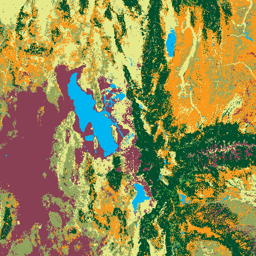
Peta Tutupan Lahan Iran v1 13 kelas (2017)
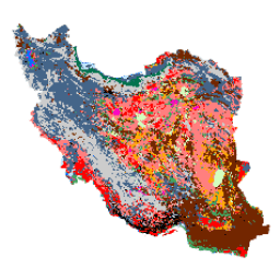
Peta tutupan lahan di seluruh Iran dihasilkan dengan memproses gambar Sentinel dalam platform Cloud Google Earth Engine. Untuk tujuan ini, lebih dari 2.500 gambar Sentinel-1 dan lebih dari 11.000 gambar Sentinel-2 diproses untuk menghasilkan satu set data mosaik untuk tahun 2017. Kemudian, Random berbasis objek … landcover landuse-landcover -
LUCAS Copernicus (Poligon dengan atribut, 2018) V1
Survei kerangka Area Penggunaan/Penutupan Lahan (LUCAS) di Uni Eropa (EU) disiapkan untuk memberikan informasi statistik. Ini merupakan latihan pengumpulan data penggunaan lahan dan penutup lahan in-situ tiga tahunan yang mencakup seluruh wilayah Uni Eropa. LUCAS mengumpulkan informasi tentang penutupan lahan dan … copernicus eu jrc landcover landuse landuse-landcover -
LUCAS Harmonized (Theoretical Location, 2006-2018) V1

Survei kerangka Area Penggunaan/Penutupan Lahan (LUCAS) di Uni Eropa (EU) disiapkan untuk memberikan informasi statistik. Ini merupakan latihan pengumpulan data penggunaan lahan dan penutup lahan in-situ tiga tahunan yang mencakup seluruh wilayah Uni Eropa. LUCAS mengumpulkan informasi tentang penutupan lahan dan … eu jrc landcover landuse landuse-landcover lucas -
LUCAS THLOC (Points with attributes, 2022) V1
Survei kerangka Area Penggunaan/Penutupan Lahan (LUCAS) di Uni Eropa (EU) disiapkan untuk memberikan informasi statistik. Ini merupakan latihan pengumpulan data penggunaan lahan dan penutup lahan in-situ tiga tahunan yang mencakup seluruh wilayah Uni Eropa. LUCAS mengumpulkan informasi tentang penutupan lahan dan … eu jrc landcover landuse landuse-landcover lucas -
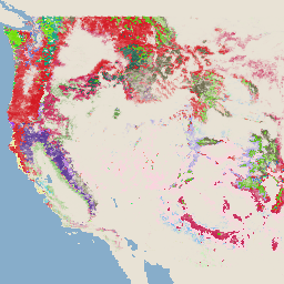
Tutupan Lahan Amerika Utara pada 30 meter, 2020

Set data Tutupan Lahan Amerika Utara 30 meter tahun 2020 dibuat sebagai bagian dari North American Land Change Monitoring System (NALCMS), upaya trilateral antara Natural Resources Canada, United States Geological Survey, dan tiga organisasi Meksiko termasuk National Institute of Statistics and Geography … landcover landsat landuse-landcover nlcd reflectance -
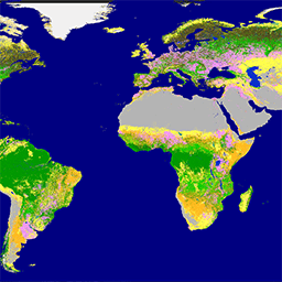
MCD12C1.061 MODIS Land Cover Type Yearly Global 0.05 Deg CMG

Produk data Terra dan Aqua Moderate Resolution Imaging Spectroradiometer (MODIS) Land Cover Climate Modeling Grid (CMG) (MCD12C1) Versi 6.1 yang digabungkan menyediakan versi produk data MCD12Q1 Versi 6.1 yang dikelompokkan secara spasial dan diproyeksikan ulang. Peta International Geosphere-Biosphere Programme (IGBP), University of … landcover landuse-landcover modis nasa usgs yearly -
MCD12Q1.061 MODIS Land Cover Type Yearly Global 500m

Produk data Terra dan Aqua Moderate Resolution Imaging Spectroradiometer (MODIS) Land Cover Type (MCD12Q1) Versi 6.1 yang digabungkan memberikan jenis tutupan lahan global pada interval tahunan. Produk data MCD12Q1 Versi 6.1 diperoleh menggunakan klasifikasi terawasi dari data reflektansi MODIS Terra dan Aqua. Daratan … landcover landuse-landcover modis nasa usgs yearly -
Gambar Tingkat Keparahan Luka Bakar Monitoring Trends in Burn Severity (MTBS)

Mosaik tingkat keparahan kebakaran terdiri dari gambar raster tematik kelas tingkat keparahan kebakaran MTBS untuk semua kebakaran MTBS yang saat ini telah selesai di Amerika Serikat kontinental, Alaska, Hawaii, dan Puerto Riko. Gambar tingkat keparahan kebakaran yang disusun dalam mozaik dikumpulkan setiap tahun untuk setiap tahun oleh Negara Bagian AS dan … eros fire forest gtac landcover landsat-derived -
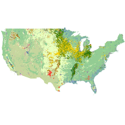
NLCD 2019: USGS National Land Cover Database, rilis 2019

NLCD (National Land Cover Database) adalah database tutupan lahan berbasis Landsat 30 m yang mencakup 8 era (2001, 2004, 2006, 2008, 2011, 2013, 2016, dan 2019). Epoch kesembilan untuk tahun 2021 juga tersedia di sini. Gambar mengandalkan lapisan data ketidakpermeabelan untuk … blm landcover landuse-landcover mrlc nlcd usgs -
NLCD 2021: USGS National Land Cover Database, rilis 2021

Survei Geologi Amerika Serikat (USGS), bekerja sama dengan beberapa lembaga federal, kini telah mengembangkan dan merilis tujuh produk National Land Cover Database (NLCD): NLCD 1992, 2001, 2006, 2011, 2016, 2019, dan 2021. Dimulai dengan rilis tahun 2016, produk cakupan lahan dibuat untuk interval dua hingga tiga tahun … blm landcover landuse-landcover mrlc nlcd usgs -
Oxford MAP: Malaria Atlas Project Fractional International Geosphere-Biosphere Programme Landcover
Set data yang mendasari produk tutupan lahan ini adalah lapisan IGBP yang ditemukan dalam produk tutupan lahan tahunan MODIS (MCD12Q1). Data ini dikonversi dari format kategorinya, yang memiliki resolusi ≈500 meter, ke produk pecahan yang menunjukkan persentase bilangan bulat (0-100) output … landcover landuse-landcover map -
SBTN Natural Lands Map v1

SBTN Natural Lands Map v1 adalah peta dasar tahun 2020 tentang cakupan lahan alami dan non-alami yang ditujukan untuk digunakan oleh perusahaan yang menetapkan target berbasis sains untuk alam, khususnya target SBTN Land #1: tidak ada konversi ekosistem alami. Definisi "alami" dan "tidak alami" diadaptasi dari … ecosystems landcover landuse-landcover wri -
SBTN Natural Lands Map v1.1

SBTN Natural Lands Map v1.1 adalah peta dasar tahun 2020 tentang cakupan lahan alami dan non-alami yang ditujukan untuk digunakan oleh perusahaan yang menetapkan target berbasis sains untuk alam, khususnya target SBTN Land #1: tidak ada konversi ekosistem alami. Definisi "alami" dan "tidak alami" diadaptasi dari … ecosystems landcover landuse-landcover wri -
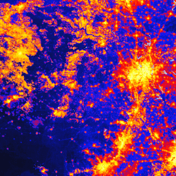
TNC Global Human Modification v3 (Change-Consistent 300m)
Set data Global Human Modification v3 mengukur tekanan kumulatif manusia pada ekosistem terestrial global (kecuali Antartika). Set data ini melacak data dari tahun 1990 hingga 2022 dan ditujukan untuk membantu mengukur dampak manusia dalam perencanaan konservasi, pembuatan kebijakan, dan penelitian. Set data ini adalah Seri "Konsisten Perubahan" (seri "c") … fragmentasi modifikasi-manusia landcover landscape-gradient population stressors -
TNC Global Human Modification v3 (Static Snapshot 90m)
Set data Global Human Modification v3 mengukur tekanan kumulatif manusia pada ekosistem terestrial global (kecuali Antartika). Set data ini melacak data dari tahun 1990 hingga 2022 dan ditujukan untuk membantu mengukur dampak manusia dalam perencanaan konservasi, pembuatan kebijakan, dan penelitian. Ini adalah snapshot statis tahun 2022 (seri "s") … fragmentasi modifikasi-manusia landcover landscape-gradient population stressors -
Lapisan Data Lahan Pertanian NASS USDA
Cropland Data Layer (CDL) adalah lapisan data tutupan lahan khusus tanaman yang dibuat setiap tahun untuk benua Amerika Serikat menggunakan citra satelit beresolusi sedang dan kebenaran nyata pertanian yang ekstensif. CDL dibuat oleh USDA, National Agricultural Statistics Service (NASS), Research and Development Division, … agriculture crop landcover usda -
USFS Landscape Change Monitoring System v2025-11 (CONUS dan OCONUS)
Produk ini adalah bagian dari rangkaian data Sistem Pemantauan Perubahan Lanskap (LCMS). Peta ini menampilkan perubahan yang dimodelkan LCMS, kelas penggunaan lahan, dan/atau kelas tutupan lahan untuk setiap tahun dan mencakup Amerika Serikat Kontinental (CONUS) serta area di luar CONUS (OCONUS) termasuk Alaska (AK), Puerto … change-detection forest gtac gtac-data-publish landcover landuse -
USFS TreeMap v2016 (Amerika Serikat Daratan)

Produk ini adalah bagian dari rangkaian data TreeMap. Data ini memberikan informasi spasial terperinci tentang karakteristik hutan, termasuk jumlah pohon hidup dan mati, biomassa, dan karbon di seluruh kawasan hutan di benua Amerika Serikat pada tahun 2016. TreeMap v2016 berisi satu gambar, … biomass carbon climate-change conus forest forest-biomass -
USFS TreeMap v2020
Produk ini adalah bagian dari rangkaian data TreeMap. Data ini memberikan informasi spasial mendetail tentang karakteristik hutan, termasuk jumlah pohon hidup dan mati, biomassa, dan karbon di seluruh kawasan hutan di Amerika Serikat pada tahun 2020. TreeMap v2020 berisi 22 band 30 x 30 m … aboveground biomass carbon climate-change conus forest -
USFS TreeMap v2022

Produk ini adalah bagian dari rangkaian data TreeMap. Data ini memberikan informasi spasial terperinci tentang karakteristik hutan, termasuk jumlah pohon hidup dan mati, biomassa, dan karbon di seluruh kawasan hutan di Amerika Serikat pada tahun 2022. TreeMap v2022 berisi 22 band 30 x 30 m … aboveground biomass carbon climate-change conus forest -
USGS GAP Alaska 2001

Data GAP/LANDFIRE National Terrestrial Ecosystems menampilkan klasifikasi tutupan lahan dan vegetasi yang mendetail untuk Amerika Serikat Daratan, Ekosistem GAP/LF 2011 untuk Amerika Serikat yang berbatasan dengan Kanada dan Meksiko adalah update dari Data Cakupan Lahan Program Analisis Kesenjangan Nasional - Versi 2.2. Alaska … ecosystems gap landcover landfire usgs vegetation -
USGS GAP CONUS 2011

Data GAP/LANDFIRE National Terrestrial Ecosystems menampilkan klasifikasi tutupan lahan dan vegetasi yang mendetail untuk Amerika Serikat Daratan, Ekosistem GAP/LF 2011 untuk Amerika Serikat yang berbatasan dengan Kanada dan Meksiko adalah update dari Data Cakupan Lahan Program Analisis Kesenjangan Nasional - Versi 2.2. Alaska … ecosystems gap landcover landfire usgs vegetation -
USGS GAP Hawaii 2001

Data GAP/LANDFIRE National Terrestrial Ecosystems menampilkan klasifikasi tutupan lahan dan vegetasi yang mendetail untuk Amerika Serikat Daratan, Ekosistem GAP/LF 2011 untuk Amerika Serikat yang berbatasan dengan Kanada dan Meksiko adalah update dari Data Cakupan Lahan Program Analisis Kesenjangan Nasional - Versi 2.2. Alaska … ecosystems gap landcover landfire usgs vegetation -
USGS GAP Puerto Rico 2001

Data GAP/LANDFIRE National Terrestrial Ecosystems menampilkan klasifikasi tutupan lahan dan vegetasi yang mendetail untuk Amerika Serikat Daratan, Ekosistem GAP/LF 2011 untuk Amerika Serikat yang berbatasan dengan Kanada dan Meksiko adalah update dari Data Cakupan Lahan Program Analisis Kesenjangan Nasional - Versi 2.2. Alaska … ecosystems gap landcover landfire usgs vegetation -
Jejak Permukiman Dunia 2015
World Settlement Footprint (WSF) 2015 adalah masker biner resolusi 10 m yang menguraikan luas permukiman manusia secara global yang diperoleh dengan menggunakan gambar multitemporal Landsat-8 dan Sentinel-1 tahun 2014-2015 (yang masing-masing telah diproses sekitar 217.000 dan 107.000 gambar). Dinamika temporal permukiman manusia … landcover landsat-derived population sentinel1-derived settlement urban