-
Batas Area Terbakar MTBS

Set data batas area terbakar Monitoring Trends in Burn Severity (MTBS) berisi poligon luas area terbakar dari semua kebakaran MTBS yang saat ini telah selesai untuk Amerika Serikat kontinental, Alaska, Hawaii, dan Puerto Riko. Di bawah, NBR adalah singkatan dari "Normalized Burn Ratio", sedangkan dNBR adalah singkatan dari … eros fire gtac mtbs table usda -
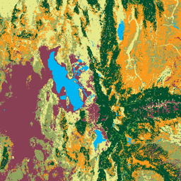
Gambar Tingkat Keparahan Kebakaran Monitoring Trends in Burn Severity (MTBS)

Mosaik tingkat keparahan kebakaran terdiri dari gambar raster tematik kelas tingkat keparahan kebakaran MTBS untuk semua kebakaran MTBS yang saat ini telah selesai untuk Amerika Serikat kontinental, Alaska, Hawaii, dan Puerto Riko. Gambar mosaik tingkat keparahan kebakaran dikumpulkan setiap tahun untuk setiap tahun oleh Negara Bagian AS dan … eros fire forest gtac landcover landsat-derived -
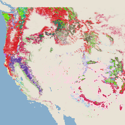
Sistem Pemantauan Perubahan Lanskap USFS v2025-11 (CONUS dan OCONUS)
Produk ini adalah bagian dari rangkaian data Sistem Pemantauan Perubahan Lanskap (LCMS). Produk ini menampilkan perubahan yang dimodelkan LCMS, penutup lahan, dan/atau kelas penggunaan lahan untuk setiap tahun dan mencakup Amerika Serikat Kontinental (CONUS) serta area di luar CONUS (OCONUS) termasuk Alaska (AK), Puerto … change-detection forest gtac landcover landuse landuse-landcover -
Penutup Kanopi Pohon USFS v2023-5 (CONUS dan OCONUS)

Ringkasan Rangkaian data Penutup Kanopi Pohon (TCC), yang diproduksi oleh Departemen Pertanian Amerika Serikat, Forest Service (USFS), adalah output peta berbasis penginderaan jauh tahunan yang mencakup tahun 1985-2023. Data ini mendukung project National Land Cover Database (NLCD), yang dikelola oleh US Geological … forest gtac landuse-landcover redcastle-resources usda usfs -
TreeMap USFS v2016 (Amerika Serikat Kontinental)

Produk ini adalah bagian dari rangkaian data TreeMap. Produk ini memberikan informasi spasial mendetail tentang karakteristik hutan termasuk jumlah pohon hidup dan mati, biomassa, dan karbon di seluruh luas hutan Amerika Serikat kontinental pada tahun 2016. TreeMap v2016 berisi satu gambar, yaitu … biomass carbon climate-change conus forest forest-biomass -
TreeMap USFS v2020
Produk ini adalah bagian dari rangkaian data TreeMap. Produk ini memberikan informasi spasial mendetail tentang karakteristik hutan termasuk jumlah pohon hidup dan mati, biomassa, dan karbon di seluruh luas hutan Amerika Serikat pada tahun 2020. TreeMap v2020 berisi gambar raster 22 band 30 x 30 m … aboveground biomass carbon climate-change conus forest -
TreeMap USFS v2022

Produk ini adalah bagian dari rangkaian data TreeMap. Produk ini memberikan informasi spasial mendetail tentang karakteristik hutan termasuk jumlah pohon hidup dan mati, biomassa, dan karbon di seluruh luas hutan Amerika Serikat pada tahun 2022. TreeMap v2022 berisi gambar raster 22 band 30 x 30 m … aboveground biomass carbon climate-change conus forest