Datasets tagged dem in Earth Engine
Оптимизируйте свои подборки
Сохраняйте и классифицируйте контент в соответствии со своими настройками.
AHN Нидерланды, цифровая модель рельефа 0,5 м, интерполированная.
Цифровая модель рельефа AHN (DEM) — это модель рельефа с разрешением 0,5 м, охватывающая территорию Нидерландов. Она была создана на основе данных LIDAR, полученных весной 2007-2012 годов. Модель содержит данные об уровне земли, из которых удалены все остальные объекты над землей (такие как здания, мосты, деревья и т. д.). Эта версия…
AHN Нидерланды, цифровая модель рельефа 0,5 м, без интерполяции
Цифровая модель рельефа AHN (DEM) — это модель рельефа с разрешением 0,5 м, охватывающая территорию Нидерландов. Она была создана на основе данных LIDAR, полученных весной 2007-2012 годов. Модель содержит данные об уровне земли, из которых удалены все остальные объекты над землей (такие как здания, мосты, деревья и т. д.). Эта версия…
AHN Нидерланды, цифровая модель рельефа 0,5 м, необработанные образцы.
Цифровая модель рельефа AHN (цифровая модель рельефа) — это модель рельефа с разрешением 0,5 м, охватывающая территорию Нидерландов. Она была создана на основе данных LIDAR, полученных весной 2007-2012 годов. Эта версия содержит как данные с уровня земли, так и данные об объектах, расположенных выше уровня земли (таких как здания, мосты, деревья и т. д.). Облако точек…
Actueel Hoogtebestand Nederland (AHN) — это набор данных с подробными и точными данными о высоте местности на всей территории Нидерландов. Информация о высоте была собрана с вертолетов и самолетов с использованием лазерной технологии с вертикальной точностью 5 см. Набор данных AHN3 содержит цифровую модель рельефа Нидерландов AHN с разрешением 0,5 м…
Actueel Hoogtebestand Nederland (AHN) — это набор данных с подробными и точными данными о высоте местности на всей территории Нидерландов. Информация о высоте была собрана с вертолетов и самолетов с использованием лазерной технологии с вертикальной точностью 5 см. Набор данных AHN4 содержит цифровую модель рельефа Нидерландов AHN с разрешением 0,5 м…
ALOS World 3D - 30m (AW3D30) — это глобальный набор данных цифровой модели поверхности (ЦМП) с горизонтальным разрешением приблизительно 30 метров (сетка 1 угловая секунда). Набор данных основан на наборе данных ЦМП (версия с сеткой 5 метров) World 3D Topographic Data. Более подробная информация…
ArcticDEM — это государственно-частная инициатива Национального агентства геопространственной разведки (NGA) и Национального научного фонда (NSF), направленная на автоматическое создание высококачественной цифровой модели поверхности (ЦМП) Арктики с использованием оптических стереоизображений, высокопроизводительных вычислений и программного обеспечения для фотограмметрии с открытым исходным кодом. Модель включает растительность, древесный покров, здания и…
ArcticDEM — это государственно-частная инициатива Национального агентства геопространственной разведки (NGA) и Национального научного фонда (NSF), направленная на автоматическое создание высококачественной цифровой модели поверхности (ЦМП) Арктики с использованием оптических стереоизображений, высокопроизводительных вычислений и программного обеспечения для фотограмметрии с открытым исходным кодом. Модель включает растительность, древесный покров, здания и…
Цифровая модель рельефа (ЦМР) Австралии с шагом 5 метров, полученная на основе модели LiDAR, представляет собой национальную ЦМР с шагом 5 метров (без учета рельефа местности), созданную на основе 236 отдельных съемок LiDAR, проведенных в период с 2001 по 2015 год и охватывающих территорию площадью более 245 000 квадратных километров.
Канадская цифровая модель рельефа (CDEM) является частью системы альтиметрии Министерства природных ресурсов Канады (NRCan) и основана на существующих канадских цифровых данных о рельефе (CDED). В этих данных высоты могут быть как наземными, так и отражающими поверхностными высотами. CDEM состоит из нескольких цифровых моделей рельефа с…
Copernicus DEM GLO-30: Глобальная цифровая модель рельефа с разрешением 30 м.
Цифровая модель поверхности Земли (ЦМР) Copernicus представляет собой изображение поверхности Земли, включая здания, инфраструктуру и растительность. Эта ЦМР получена из отредактированной ЦМР под названием WorldDEM™, то есть в нее включены выравнивание водных объектов и равномерное течение рек. Редактирование…
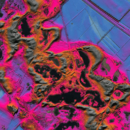
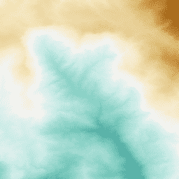
ЦМР 1 км, полученная с помощью криоспутника CryoSat-2 в Антарктиде
Данный набор данных представляет собой цифровую модель рельефа (ЦМР) антарктического ледового щита и шельфовых ледников, основанную на наблюдениях, зарегистрированных радиолокационным альтиметром спутника CryoSat-2 в период с июля 2010 по июль 2016 года. ЦМР формируется путем пространственно-временной подгонки к измерениям высоты, накопленным в течение 1…
DEM-H: Австралийская цифровая модель рельефа, созданная с учетом гидрологических требований (SRTM).
Цифровая модель рельефа с учетом гидрологических условий (DEM-H) была создана на основе данных SRTM, полученных НАСА в феврале 2000 года. Модель была оптимизирована с учетом гидрологических условий и дренажа. DEM-H фиксирует пути течения на основе высот SRTM и нанесенных на карту линий водотоков, а также поддерживает определение…
DEM-S: Австралийская сглаженная цифровая модель рельефа
Сглаженная цифровая модель рельефа (DEM-S) была получена на основе данных SRTM, собранных НАСА в феврале 2000 года. DEM-S представляет собой топографию поверхности земли (за исключением растительности) и была сглажена для уменьшения шума и улучшения отображения формы поверхности. Для этого был применен адаптивный процесс…
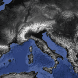
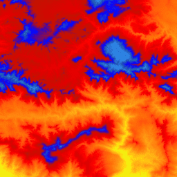
ETOPO1: Глобальная угловая высота 1 угловая минута
ETOPO1 — это глобальная модель рельефа земной поверхности с разрешением 1 угловая минута, которая объединяет топографию суши и батиметрию океана. Она была построена на основе многочисленных глобальных и региональных наборов данных. Она содержит два диапазона высот: поверхность льда и коренная порода.
Англия, 1-метровая сводная цифровая модель рельефа/цифровая модель поверхности (Агентство по охране окружающей среды)
Композитная цифровая модель рельефа (ЦМР) на основе данных LIDAR представляет собой растровую модель местности, охватывающую около 99% территории Англии с пространственным разрешением 1 м, созданную Агентством по охране окружающей среды Великобритании в 2022 году. Модель содержит 3 канала данных о рельефе: цифровую модель рельефа (ЦМР), цифровую модель поверхности (ЦМП) первого поколения, …
Этот пространственный растровый набор данных отображает глобальное распределение высот зданий с разрешением 100 м по состоянию на 2018 год. В качестве входных данных для прогнозирования высот зданий использовались глобальная цифровая модель поверхности ALOS (30 м), данные радиолокационной топографической миссии космического шаттла NASA…
GHSL: Объемы строительства в мире 1975-2030 гг. (P2023A)
Этот растровый набор данных отображает глобальное распределение объема застройки, выраженное в кубических метрах на 100 м³ ячейки сетки. Набор данных измеряет общий объем застройки и объем застройки, выделенный для ячеек сетки с преобладающим нежилым использованием (НЖУ). Оценки основаны на застроенной площади…
GMTED2010: Глобальные многоуровневые данные о высоте местности 2010 года
Глобальный многоразрешенный набор данных о высоте рельефа 2010 года (GMTED2010) содержит данные о высоте земного шара, собранные из различных источников с разрешением 7,5 угловых секунд. Более подробная информация доступна в отчете по набору данных. Основным источником данных для GMTED2010 являются цифровые данные о высоте рельефа SRTM (DTED®) Национального агентства геофизики (NGA).
GTOPO30: Глобальная топографическая карта с шагом 30 угловых секунд.
GTOPO30 — это глобальная цифровая модель рельефа (ЦМР) с горизонтальным шагом сетки 30 угловых секунд (приблизительно 1 километр). ЦМР была получена из нескольких растровых и векторных источников топографической информации. Разработка GTOPO30, завершенная в конце 1996 года, заняла три года…
MERIT DEM: Улучшенная цифровая модель рельефа с устранением множественных ошибок
MERIT DEM — это высокоточная глобальная цифровая модель рельефа (ЦМР) с разрешением 3 угловые секунды (~90 м на экваторе), созданная путем устранения основных компонентов ошибок из существующих ЦМР (NASA SRTM3 DEM, JAXA AW3D DEM, Viewfinder Panoramas DEM). MERIT DEM разделяет абсолютное смещение, полосовой шум, спекл-шум и…
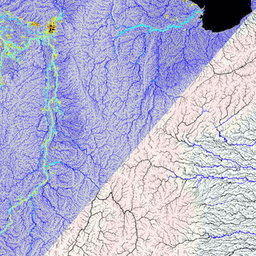
MERIT Hydro: Глобальные гидрографические наборы данных
MERIT Hydro — это новая глобальная карта направлений потока с разрешением 3 угловые секунды (~90 м на экваторе), полученная на основе данных о высоте MERIT DEM и наборов данных о водных объектах (G1WBM, GSWO и OpenStreetMap) версии 1.0.3. MERIT Hydro содержит результаты нового…
Цифровые данные о рельефе, полученные в рамках миссии Shuttle Radar Topography Mission (SRTM, см. Farr et al. 2007), представляют собой международный исследовательский проект, в результате которого были получены цифровые модели рельефа в масштабе, близком к глобальному. Этот продукт SRTM V3 (SRTM Plus) предоставляется Лабораторией реактивного движения НАСА с разрешением 1 угловая секунда…
NASADEM — это переобработка данных SRTM с улучшенной точностью за счет включения вспомогательных данных из наборов данных ASTER GDEM, ICESat GLAS и PRISM. Наиболее значительные улучшения обработки связаны с уменьшением пустот за счет улучшенного развертывания фазы и использованием данных ICESat GLAS для контроля. Документация: Руководство пользователя
Цифровые модели поверхности (ЦМП) и рельефа (ЦМР), полученные на основе данных лидара NEON. ЦМП: Характеристики поверхности (топографическая информация с учетом растительности и искусственных сооружений). ЦМР: Высота над уровнем моря (топографическая информация без учета растительности и искусственных сооружений). Изображения представлены в метрах над уровнем моря…
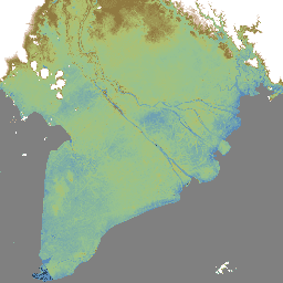
Предварительный просмотр Национальной цифровой модели рельефа приливной зоны 25 м 1.0.0
Национальная цифровая модель рельефа приливной зоны (NIDEM; Bishop-Taylor et al. 2018, 2019) — это набор данных о рельефе континентального масштаба для открытой приливной зоны Австралии. NIDEM впервые предоставляет трехмерное представление песчаных пляжей и берегов приливной зоны Австралии, приливных отмелей, скалистых берегов и рифов с разрешением 25 м…
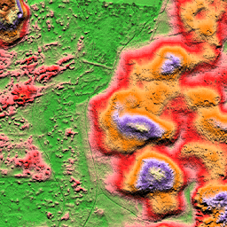
Эталонная модель рельефа Антарктиды (REMA) — это цифровая модель поверхности Антарктиды высокого разрешения с временными метками, имеющая пространственное разрешение 2 и 8 метров. Мозаичные файлы ЦМР составлены из нескольких полос, которые были совмещены, смешаны и сглажены для уменьшения артефактов, связанных с совпадением краев.
Эталонная модель рельефа Антарктиды (REMA) — это цифровая модель поверхности (DSM) Антарктиды с высоким разрешением и временными метками, имеющая пространственное разрешение 2 и 8 метров. Файлы DEM в виде полос соответствуют области перекрытия входных пар стереоскопических изображений, собранных компанией DigitalGlobe…
Эталонная модель рельефа Антарктиды (REMA) — это цифровая модель поверхности (DSM) Антарктиды с высоким разрешением и временными метками, имеющая пространственное разрешение 2 и 8 метров. Файлы DEM в виде полос соответствуют области перекрытия входных пар стереоскопических изображений, собранных компанией DigitalGlobe…
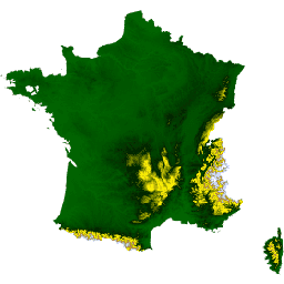
Набор данных RGE ALTI описывает цифровую модель рельефа (ЦМР) Франции с размером пикселя 1 м. Она была создана на основе данных аэрофотосъемки с использованием лидара или путем корреляции аэрофотоснимков. Лидар применялся в районах, подверженных наводнениям, прибрежных зонах и крупных лесных массивах. Вертикальная…
Цифровые данные о рельефе местности, полученные в рамках миссии Shuttle Radar Topography Mission (SRTM), изначально были созданы для обеспечения согласованных и высококачественных данных о рельефе местности в масштабах, близких к глобальному. Данная версия цифровых данных о рельефе местности SRTM была обработана для заполнения пробелов в данных и упрощения их использования.
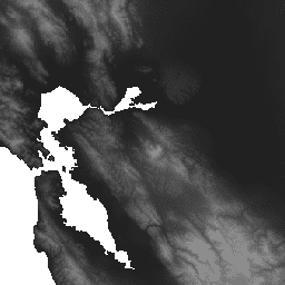
3D-карта США (USGS) масштабом 10 м, бесшовная (1/3 угловой секунды).
Это цельный набор данных 3DEP DEM для США с полным покрытием 48 смежных штатов, Гавайев и территорий США. Покрытие Аляски частично доступно уже сейчас и расширяется до охвата всего штата в рамках Инициативы по картографированию Аляски. Расстояние между точками на местности…
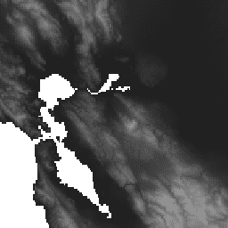
Это набор фрагментированных изображений с размером пикселя 1 м из программы 3D-моделирования рельефа (3DEP). Данные 3DEP служат слоем рельефа для Национальной карты и предоставляют базовую информацию о высоте для исследований в области наук о Земле и картографических приложений в Соединенных Штатах…
WWF HydroSHEDS Гидрологически обоснованная цифровая модель рельефа, 15 угловых секунд
HydroSHEDS — это картографический продукт, предоставляющий гидрографическую информацию для региональных и глобальных приложений в согласованном формате. Он предлагает набор геопривязанных наборов данных (векторных и растровых) в различных масштабах, включая речные сети, границы водосборных бассейнов, направления стока и накопление воды. HydroSHEDS основан на…
WWF HydroSHEDS Гидрологически обоснованная цифровая модель рельефа, 3 угловые секунды
HydroSHEDS — это картографический продукт, предоставляющий гидрографическую информацию для региональных и глобальных приложений в согласованном формате. Он предлагает набор геопривязанных наборов данных (векторных и растровых) в различных масштабах, включая речные сети, границы водосборных бассейнов, направления стока и накопление воды. HydroSHEDS основан на…
WWF HydroSHEDS Гидрологически обоснованная цифровая модель рельефа, 30 угловых секунд
HydroSHEDS — это картографический продукт, предоставляющий гидрографическую информацию для региональных и глобальных приложений в согласованном формате. Он предлагает набор геопривязанных наборов данных (векторных и растровых) в различных масштабах, включая речные сети, границы водосборных бассейнов, направления стока и накопление воды. HydroSHEDS основан на…
WWF HydroSHEDS Цифровая модель рельефа с заполнением пустот, 3 угловые секунды
HydroSHEDS — это картографический продукт, предоставляющий гидрографическую информацию для региональных и глобальных приложений в согласованном формате. Он предлагает набор геопривязанных наборов данных (векторных и растровых) в различных масштабах, включая речные сети, границы водосборных бассейнов, направления стока и накопление воды. HydroSHEDS основан на…
[[["Прост для понимания","easyToUnderstand","thumb-up"],["Помог мне решить мою проблему","solvedMyProblem","thumb-up"],["Другое","otherUp","thumb-up"]],[["Отсутствует нужная мне информация","missingTheInformationINeed","thumb-down"],["Слишком сложен/слишком много шагов","tooComplicatedTooManySteps","thumb-down"],["Устарел","outOfDate","thumb-down"],["Проблема с переводом текста","translationIssue","thumb-down"],["Проблемы образцов/кода","samplesCodeIssue","thumb-down"],["Другое","otherDown","thumb-down"]],[],[],[]]