Datasets tagged hydrosheds in Earth Engine
Оптимизируйте свои подборки
Сохраняйте и классифицируйте контент в соответствии со своими настройками.
MERIT Hydro: Глобальные гидрографические наборы данных
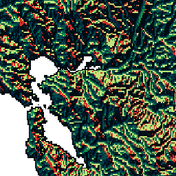
MERIT Hydro — это новая глобальная карта направлений потока с разрешением 3 угловые секунды (~90 м на экваторе), полученная на основе данных о высоте MERIT DEM и наборов данных о водных объектах (G1WBM, GSWO и OpenStreetMap) версии 1.0.3. MERIT Hydro содержит результаты нового…
BasinATLAS — это компонент базы данных HydroATLAS, которая, в свою очередь, является компонентом HydroSHEDS. BasinATLAS предоставляет стандартизированный сборник гидроэкологических характеристик для всех водосборных бассейнов мира с высоким пространственным разрешением. Этот набор данных включает данные по 56 переменным, разделенным на 281 атрибут и…
BasinATLAS — это компонент базы данных HydroATLAS, которая, в свою очередь, является компонентом HydroSHEDS. BasinATLAS предоставляет стандартизированный сборник гидроэкологических характеристик для всех водосборных бассейнов мира с высоким пространственным разрешением. Этот набор данных включает данные по 56 переменным, разделенным на 281 атрибут и…
BasinATLAS — это компонент базы данных HydroATLAS, которая, в свою очередь, является компонентом HydroSHEDS. BasinATLAS предоставляет стандартизированный сборник гидроэкологических характеристик для всех водосборных бассейнов мира с высоким пространственным разрешением. Этот набор данных включает данные по 56 переменным, разделенным на 281 атрибут и…
BasinATLAS — это компонент базы данных HydroATLAS, которая, в свою очередь, является компонентом HydroSHEDS. BasinATLAS предоставляет стандартизированный сборник гидроэкологических характеристик для всех водосборных бассейнов мира с высоким пространственным разрешением. Этот набор данных включает данные по 56 переменным, разделенным на 281 атрибут и…
BasinATLAS — это компонент базы данных HydroATLAS, которая, в свою очередь, является компонентом HydroSHEDS. BasinATLAS предоставляет стандартизированный сборник гидроэкологических характеристик для всех водосборных бассейнов мира с высоким пространственным разрешением. Этот набор данных включает данные по 56 переменным, разделенным на 281 атрибут и…
BasinATLAS — это компонент базы данных HydroATLAS, которая, в свою очередь, является компонентом HydroSHEDS. BasinATLAS предоставляет стандартизированный сборник гидроэкологических характеристик для всех водосборных бассейнов мира с высоким пространственным разрешением. Этот набор данных включает данные по 56 переменным, разделенным на 281 атрибут и…
BasinATLAS — это компонент базы данных HydroATLAS, которая, в свою очередь, является компонентом HydroSHEDS. BasinATLAS предоставляет стандартизированный сборник гидроэкологических характеристик для всех водосборных бассейнов мира с высоким пространственным разрешением. Этот набор данных включает данные по 56 переменным, разделенным на 281 атрибут и…
BasinATLAS — это компонент базы данных HydroATLAS, которая, в свою очередь, является компонентом HydroSHEDS. BasinATLAS предоставляет стандартизированный сборник гидроэкологических характеристик для всех водосборных бассейнов мира с высоким пространственным разрешением. Этот набор данных включает данные по 56 переменным, разделенным на 281 атрибут и…
BasinATLAS — это компонент базы данных HydroATLAS, которая, в свою очередь, является компонентом HydroSHEDS. BasinATLAS предоставляет стандартизированный сборник гидроэкологических характеристик для всех водосборных бассейнов мира с высоким пространственным разрешением. Этот набор данных включает данные по 56 переменным, разделенным на 281 атрибут и…
BasinATLAS — это компонент базы данных HydroATLAS, которая, в свою очередь, является компонентом HydroSHEDS. BasinATLAS предоставляет стандартизированный сборник гидроэкологических характеристик для всех водосборных бассейнов мира с высоким пространственным разрешением. Этот набор данных включает данные по 56 переменным, разделенным на 281 атрибут и…
HydroSHEDS — это картографический продукт, предоставляющий гидрографическую информацию для региональных и глобальных приложений в согласованном формате. Он предлагает набор геопривязанных наборов данных (векторных и растровых) в различных масштабах, включая речные сети, границы водосборных бассейнов, направления стока и накопление воды. HydroSHEDS основан на…
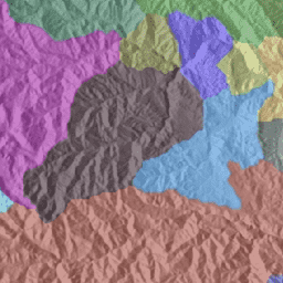
Бассейны гидротехнического обслуживания WWF, уровень 10
HydroSHEDS — это картографический продукт, предоставляющий гидрографическую информацию для региональных и глобальных приложений в согласованном формате. Он предлагает набор геопривязанных наборов данных (векторных и растровых) в различных масштабах, включая речные сети, границы водосборных бассейнов, направления стока и накопление воды. HydroSHEDS основан на…
Бассейны гидротехнического обслуживания WWF, уровень 11
HydroSHEDS — это картографический продукт, предоставляющий гидрографическую информацию для региональных и глобальных приложений в согласованном формате. Он предлагает набор геопривязанных наборов данных (векторных и растровых) в различных масштабах, включая речные сети, границы водосборных бассейнов, направления стока и накопление воды. HydroSHEDS основан на…
Бассейны гидротехнического обслуживания WWF, уровень 12
HydroSHEDS — это картографический продукт, предоставляющий гидрографическую информацию для региональных и глобальных приложений в согласованном формате. Он предлагает набор геопривязанных наборов данных (векторных и растровых) в различных масштабах, включая речные сети, границы водосборных бассейнов, направления стока и накопление воды. HydroSHEDS основан на…
HydroSHEDS — это картографический продукт, предоставляющий гидрографическую информацию для региональных и глобальных приложений в согласованном формате. Он предлагает набор геопривязанных наборов данных (векторных и растровых) в различных масштабах, включая речные сети, границы водосборных бассейнов, направления стока и накопление воды. HydroSHEDS основан на…
HydroSHEDS — это картографический продукт, предоставляющий гидрографическую информацию для региональных и глобальных приложений в согласованном формате. Он предлагает набор геопривязанных наборов данных (векторных и растровых) в различных масштабах, включая речные сети, границы водосборных бассейнов, направления стока и накопление воды. HydroSHEDS основан на…
HydroSHEDS — это картографический продукт, предоставляющий гидрографическую информацию для региональных и глобальных приложений в согласованном формате. Он предлагает набор геопривязанных наборов данных (векторных и растровых) в различных масштабах, включая речные сети, границы водосборных бассейнов, направления стока и накопление воды. HydroSHEDS основан на…
HydroSHEDS — это картографический продукт, предоставляющий гидрографическую информацию для региональных и глобальных приложений в согласованном формате. Он предлагает набор геопривязанных наборов данных (векторных и растровых) в различных масштабах, включая речные сети, границы водосборных бассейнов, направления стока и накопление воды. HydroSHEDS основан на…
HydroSHEDS — это картографический продукт, предоставляющий гидрографическую информацию для региональных и глобальных приложений в согласованном формате. Он предлагает набор геопривязанных наборов данных (векторных и растровых) в различных масштабах, включая речные сети, границы водосборных бассейнов, направления стока и накопление воды. HydroSHEDS основан на…
HydroSHEDS — это картографический продукт, предоставляющий гидрографическую информацию для региональных и глобальных приложений в согласованном формате. Он предлагает набор геопривязанных наборов данных (векторных и растровых) в различных масштабах, включая речные сети, границы водосборных бассейнов, направления стока и накопление воды. HydroSHEDS основан на…
HydroSHEDS — это картографический продукт, предоставляющий гидрографическую информацию для региональных и глобальных приложений в согласованном формате. Он предлагает набор геопривязанных наборов данных (векторных и растровых) в различных масштабах, включая речные сети, границы водосборных бассейнов, направления стока и накопление воды. HydroSHEDS основан на…
HydroSHEDS — это картографический продукт, предоставляющий гидрографическую информацию для региональных и глобальных приложений в согласованном формате. Он предлагает набор геопривязанных наборов данных (векторных и растровых) в различных масштабах, включая речные сети, границы водосборных бассейнов, направления стока и накопление воды. HydroSHEDS основан на…
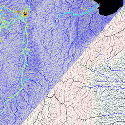
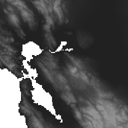
Направление дренажа согласно данным WWF HydroSHEDS, 15 угловых секунд
HydroSHEDS — это картографический продукт, предоставляющий гидрографическую информацию для региональных и глобальных приложений в согласованном формате. Он предлагает набор геопривязанных наборов данных (векторных и растровых) в различных масштабах, включая речные сети, границы водосборных бассейнов, направления стока и накопление воды. HydroSHEDS основан на…
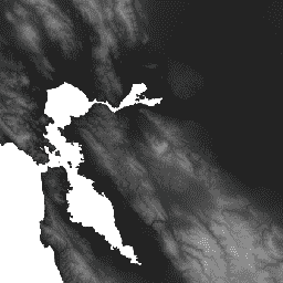
Направление дренажа WWF HydroSHEDS, 3 угловые секунды
HydroSHEDS — это картографический продукт, предоставляющий гидрографическую информацию для региональных и глобальных приложений в согласованном формате. Он предлагает набор геопривязанных наборов данных (векторных и растровых) в различных масштабах, включая речные сети, границы водосборных бассейнов, направления стока и накопление воды. HydroSHEDS основан на…
Направление дренажа согласно данным WWF HydroSHEDS, 30 угловых секунд
HydroSHEDS — это картографический продукт, предоставляющий гидрографическую информацию для региональных и глобальных приложений в согласованном формате. Он предлагает набор геопривязанных наборов данных (векторных и растровых) в различных масштабах, включая речные сети, границы водосборных бассейнов, направления стока и накопление воды. HydroSHEDS основан на…
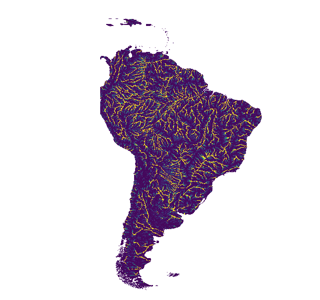
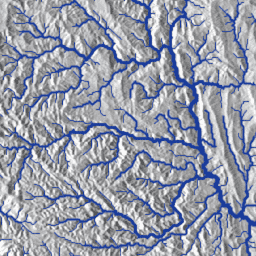
Накопление стока по данным WWF HydroSHEDS, 15 угловых секунд.
HydroSHEDS — это картографический продукт, предоставляющий гидрографическую информацию для региональных и глобальных приложений в согласованном формате. Он предлагает набор геопривязанных наборов данных (векторных и растровых) в различных масштабах, включая речные сети, границы водосборных бассейнов, направления стока и накопление воды. HydroSHEDS основан на…
Накопление стока по данным WWF HydroSHEDS, 30 угловых секунд.
HydroSHEDS — это картографический продукт, предоставляющий гидрографическую информацию для региональных и глобальных приложений в согласованном формате. Он предлагает набор геопривязанных наборов данных (векторных и растровых) в различных масштабах, включая речные сети, границы водосборных бассейнов, направления стока и накопление воды. HydroSHEDS основан на…
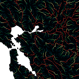
Сеть свободно текущих рек WWF HydroSHEDS, версия 1
HydroSHEDS — это картографический продукт, предоставляющий гидрографическую информацию для региональных и глобальных приложений в согласованном формате. Он предлагает набор геопривязанных наборов данных (векторных и растровых) в различных масштабах, включая речные сети, границы водосборных бассейнов, направления стока и накопление воды. HydroSHEDS основан на…
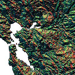
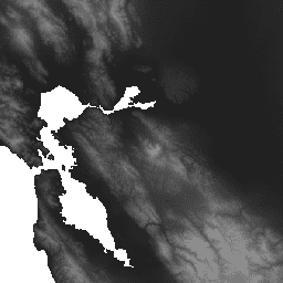
WWF HydroSHEDS Гидрологически обоснованная цифровая модель рельефа, 15 угловых секунд
HydroSHEDS — это картографический продукт, предоставляющий гидрографическую информацию для региональных и глобальных приложений в согласованном формате. Он предлагает набор геопривязанных наборов данных (векторных и растровых) в различных масштабах, включая речные сети, границы водосборных бассейнов, направления стока и накопление воды. HydroSHEDS основан на…
WWF HydroSHEDS Гидрологически обоснованная цифровая модель рельефа, 3 угловые секунды
HydroSHEDS — это картографический продукт, предоставляющий гидрографическую информацию для региональных и глобальных приложений в согласованном формате. Он предлагает набор геопривязанных наборов данных (векторных и растровых) в различных масштабах, включая речные сети, границы водосборных бассейнов, направления стока и накопление воды. HydroSHEDS основан на…
WWF HydroSHEDS Гидрологически обоснованная цифровая модель рельефа, 30 угловых секунд
HydroSHEDS — это картографический продукт, предоставляющий гидрографическую информацию для региональных и глобальных приложений в согласованном формате. Он предлагает набор геопривязанных наборов данных (векторных и растровых) в различных масштабах, включая речные сети, границы водосборных бассейнов, направления стока и накопление воды. HydroSHEDS основан на…
WWF HydroSHEDS Цифровая модель рельефа с заполнением пустот, 3 угловые секунды
HydroSHEDS — это картографический продукт, предоставляющий гидрографическую информацию для региональных и глобальных приложений в согласованном формате. Он предлагает набор геопривязанных наборов данных (векторных и растровых) в различных масштабах, включая речные сети, границы водосборных бассейнов, направления стока и накопление воды. HydroSHEDS основан на…
[[["Прост для понимания","easyToUnderstand","thumb-up"],["Помог мне решить мою проблему","solvedMyProblem","thumb-up"],["Другое","otherUp","thumb-up"]],[["Отсутствует нужная мне информация","missingTheInformationINeed","thumb-down"],["Слишком сложен/слишком много шагов","tooComplicatedTooManySteps","thumb-down"],["Устарел","outOfDate","thumb-down"],["Проблема с переводом текста","translationIssue","thumb-down"],["Проблемы образцов/кода","samplesCodeIssue","thumb-down"],["Другое","otherDown","thumb-down"]],[],[],["MERIT Hydro offers a global flow direction map derived from MERIT DEM elevation data and water body datasets, with visualization layers. WWF HydroATLAS Basins, part of HydroSHEDS, provides detailed hydro-environmental attributes for watersheds at high spatial resolution. WWF HydroSHEDS delivers hydrographic data like river networks, watershed boundaries, drainage directions, flow accumulation, and different resolution DEMs in raster and vector formats, for regional and global analyses. Basins are available in various levels and the datasets are based on the HydroSHEDS model.\n"]]