Datasets tagged river-width in Earth Engine
Оптимизируйте свои подборки
Сохраняйте и классифицируйте контент в соответствии со своими настройками.
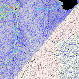
MERIT Hydro: Глобальные гидрографические наборы данных
MERIT Hydro — это новая глобальная карта направлений потока с разрешением 3 угловые секунды (~90 м на экваторе), полученная на основе данных о высоте MERIT DEM и наборов данных о водных объектах (G1WBM, GSWO и OpenStreetMap) версии 1.0.3. MERIT Hydro содержит результаты нового…
[[["Прост для понимания","easyToUnderstand","thumb-up"],["Помог мне решить мою проблему","solvedMyProblem","thumb-up"],["Другое","otherUp","thumb-up"]],[["Отсутствует нужная мне информация","missingTheInformationINeed","thumb-down"],["Слишком сложен/слишком много шагов","tooComplicatedTooManySteps","thumb-down"],["Устарел","outOfDate","thumb-down"],["Проблема с переводом текста","translationIssue","thumb-down"],["Проблемы образцов/кода","samplesCodeIssue","thumb-down"],["Другое","otherDown","thumb-down"]],[],[],["MERIT Hydro offers a global flow direction map with a 3 arc-second resolution, derived from MERIT DEM elevation data and water body datasets (G1WBM, GSWO, OpenStreetMap). It utilizes elevation, flow-direction, and hydrography data. It offers supplementary visualization layers that share the same data origins and tag categories, offering additional tools for understanding the hydrography data. The dataset focuses on mapping water flow direction globally.\n"]]