Datasets tagged ga in Earth Engine
Оптимизируйте свои подборки
Сохраняйте и классифицируйте контент в соответствии со своими настройками.
Австралийская 5M DEM
5-метровая сетка цифровой модели рельефа (ЦМР) Австралии, полученная на основе модели LiDAR, представляет собой национальную 5-метровую (голую землю) ЦМР, которая была получена на основе 236 отдельных исследований LiDAR в период с 2001 по 2015 год и охватывает территорию, превышающую 245 000 квадратных километров. …
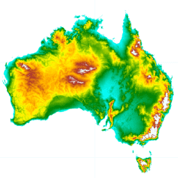
DEM-H: Австралийская гидрологически усиленная цифровая модель рельефа SRTM
Цифровая модель рельефа с гидрологической привязкой (DEM-H) была создана на основе данных SRTM, полученных NASA в феврале 2000 года. Модель прошла гидрологическую обработку и была адаптирована к дренажу. DEM-H отображает пути потоков на основе высот SRTM и нанесенных на карту линий водотока, а также поддерживает определение границ…
DEM-S: сглаженная цифровая модель рельефа Австралии
Сглаженная цифровая модель рельефа (ЦМР-S) была создана на основе данных SRTM, полученных NASA в феврале 2000 года. ЦМР-S представляет собой топографию земной поверхности (исключая особенности растительности) и была сглажена для снижения уровня шума и улучшения представления формы поверхности. Адаптивный процесс применён далее…
Предварительный просмотр национальной цифровой модели рельефа приливной зоны 25 м 1.0.0
Национальная цифровая модель рельефа приливной зоны (NIDEM; Bishop-Taylor et al. 2018, 2019) представляет собой набор данных о рельефе континентального масштаба для открытой приливной зоны Австралии. NIDEM предоставляет первое трёхмерное представление песчаных пляжей и берегов приливной зоны Австралии, приливных отмелей, скалистых берегов и рифов на глубине 25 м…
[[["Прост для понимания","easyToUnderstand","thumb-up"],["Помог мне решить мою проблему","solvedMyProblem","thumb-up"],["Другое","otherUp","thumb-up"]],[["Отсутствует нужная мне информация","missingTheInformationINeed","thumb-down"],["Слишком сложен/слишком много шагов","tooComplicatedTooManySteps","thumb-down"],["Устарел","outOfDate","thumb-down"],["Проблема с переводом текста","translationIssue","thumb-down"],["Проблемы образцов/кода","samplesCodeIssue","thumb-down"],["Другое","otherDown","thumb-down"]],[],[],["The datasets provide various models and data for Australia. These include Digital Elevation Models (DEMs) at 5m resolution from LiDAR surveys and hydrologically enforced/smoothed DEMs derived from SRTM data. The National Intertidal DEM represents Australia's intertidal zone at 25m. Also featured are Landsat-derived products like annual land cover classifications, water observation statistics, and geometric median/median absolute deviation datasets. These Landsat products utilize Landsat 5, 7, 8, and 9 data to provide insights into annual conditions and changes.\n"]]