Datasets tagged canada in Earth Engine
Оптимизируйте свои подборки
Сохраняйте и классифицируйте контент в соответствии со своими настройками.
Ежегодная инвентаризация урожая Канады AAFC
Начиная с 2009 года, группа дистанционного зондирования Земли Научно-технического отдела (STB) Министерства сельского хозяйства и продовольствия Канады (AAFC) начала процесс создания ежегодных цифровых карт типов сельскохозяйственных культур. В 2009 и 2010 годах, сосредоточившись на провинциях Прерий, была применена методология, основанная на дереве решений (DT)…
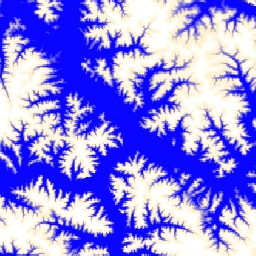
Канадская цифровая модель рельефа (CDEM) является частью системы альтиметрии Министерства природных ресурсов Канады (NRCan) и основана на существующих канадских цифровых данных о рельефе (CDED). В этих данных высоты могут быть как наземными, так и отражающими поверхностными высотами. CDEM состоит из нескольких цифровых моделей рельефа с…
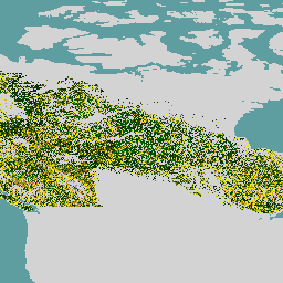
Возраст лесов в Канаде по данным спутника Landsat за 2019 год.
Канадский набор данных о первичных лесах представляет собой спутниковую карту возраста лесов за 2019 год по лесным экозонам Канады с пространственным разрешением 30 м. Для определения возраста используются данные дистанционного зондирования со спутников Landsat (нарушения, композиты поверхностного отражения, структура леса) и MODIS (валовая первичная продукция). Возраст леса может быть…
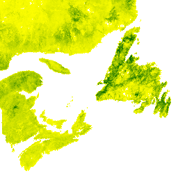
SCANFI: пространственно-ориентированные данные инвентаризации национальных лесов Канады1.2
Данная публикация содержит набор растровых файлов с разрешением 30 м, представляющих собой сплошные карты Канады 2020 года, отображающие основные типы землепользования, высоту лесного полога, степень сомкнутости крон и надземную биомассу деревьев, а также видовой состав нескольких основных видов деревьев. Пространственно-ориентированная канадская национальная…
[[["Прост для понимания","easyToUnderstand","thumb-up"],["Помог мне решить мою проблему","solvedMyProblem","thumb-up"],["Другое","otherUp","thumb-up"]],[["Отсутствует нужная мне информация","missingTheInformationINeed","thumb-down"],["Слишком сложен/слишком много шагов","tooComplicatedTooManySteps","thumb-down"],["Устарел","outOfDate","thumb-down"],["Проблема с переводом текста","translationIssue","thumb-down"],["Проблемы образцов/кода","samplesCodeIssue","thumb-down"],["Другое","otherDown","thumb-down"]],[],[],["Agriculture and Agri-Food Canada (AAFC) initiated annual crop type mapping in 2009, starting with the Prairie Provinces, using a Decision Tree methodology. A 2019 satellite-based forest age map of Canada was created utilizing Landsat and MODIS data at a 30-meter resolution. Natural Resources Canada's (NRCan) Canadian Digital Elevation Model (CDEM), part of the altimetry system, provides elevation data comprising multiple Digital Elevation Models (DEMs).\n"]]