GitHub'da kaynağı görüntüleyin
Earth Engine'da birkaç spektral dönüşüm yöntemi vardır. Bunlara, resimlerdeki normalizedDifference(), unmix(), rgbToHsv() ve hsvToRgb() gibi örnek yöntemler dahildir.
Yakınlaştırma keskinleştirme
Pan sivrileştirme, daha ince çözünürlüğe sahip ilgili bir pankromatik görüntünün sağladığı iyileştirme sayesinde çok bantlı görüntünün çözünürlüğünü artırır.
rgbToHsv() ve hsvToRgb() yöntemleri, kameranın hareketi sırasında keskinleştirme yapmak için yararlıdır.
Kod Düzenleyici (JavaScript)
// Load a Landsat 8 top-of-atmosphere reflectance image.
var image = ee.Image('LANDSAT/LC08/C02/T1_TOA/LC08_044034_20140318');
Map.addLayer(
    image,
    {bands: ['B4', 'B3', 'B2'], min: 0, max: 0.25, gamma: [1.1, 1.1, 1]},
    'rgb');

// Convert the RGB bands to the HSV color space.
var hsv = image.select(['B4', 'B3', 'B2']).rgbToHsv();

// Swap in the panchromatic band and convert back to RGB.
var sharpened = ee.Image.cat([
  hsv.select('hue'), hsv.select('saturation'), image.select('B8')
]).hsvToRgb();

// Display the pan-sharpened result.
Map.setCenter(-122.44829, 37.76664, 13);
Map.addLayer(sharpened,
             {min: 0, max: 0.25, gamma: [1.3, 1.3, 1.3]},
             'pan-sharpened');
import ee
import geemap.core as geemap
Colab (Python)
# Load a Landsat 8 top-of-atmosphere reflectance image.
image = ee.Image('LANDSAT/LC08/C02/T1_TOA/LC08_044034_20140318')

# Convert the RGB bands to the HSV color space.
hsv = image.select(['B4', 'B3', 'B2']).rgbToHsv()

# Swap in the panchromatic band and convert back to RGB.
sharpened = ee.Image.cat(
    [hsv.select('hue'), hsv.select('saturation'), image.select('B8')]
).hsvToRgb()

# Define a map centered on San Francisco, California.
map_sharpened = geemap.Map(center=[37.76664, -122.44829], zoom=13)

# Add the image layers to the map and display it.
map_sharpened.add_layer(
    image,
    {
        'bands': ['B4', 'B3', 'B2'],
        'min': 0,
        'max': 0.25,
        'gamma': [1.1, 1.1, 1],
    },
    'rgb',
)
map_sharpened.add_layer(
    sharpened,
    {'min': 0, 'max': 0.25, 'gamma': [1.3, 1.3, 1.3]},
    'pan-sharpened',
)
display(map_sharpened)
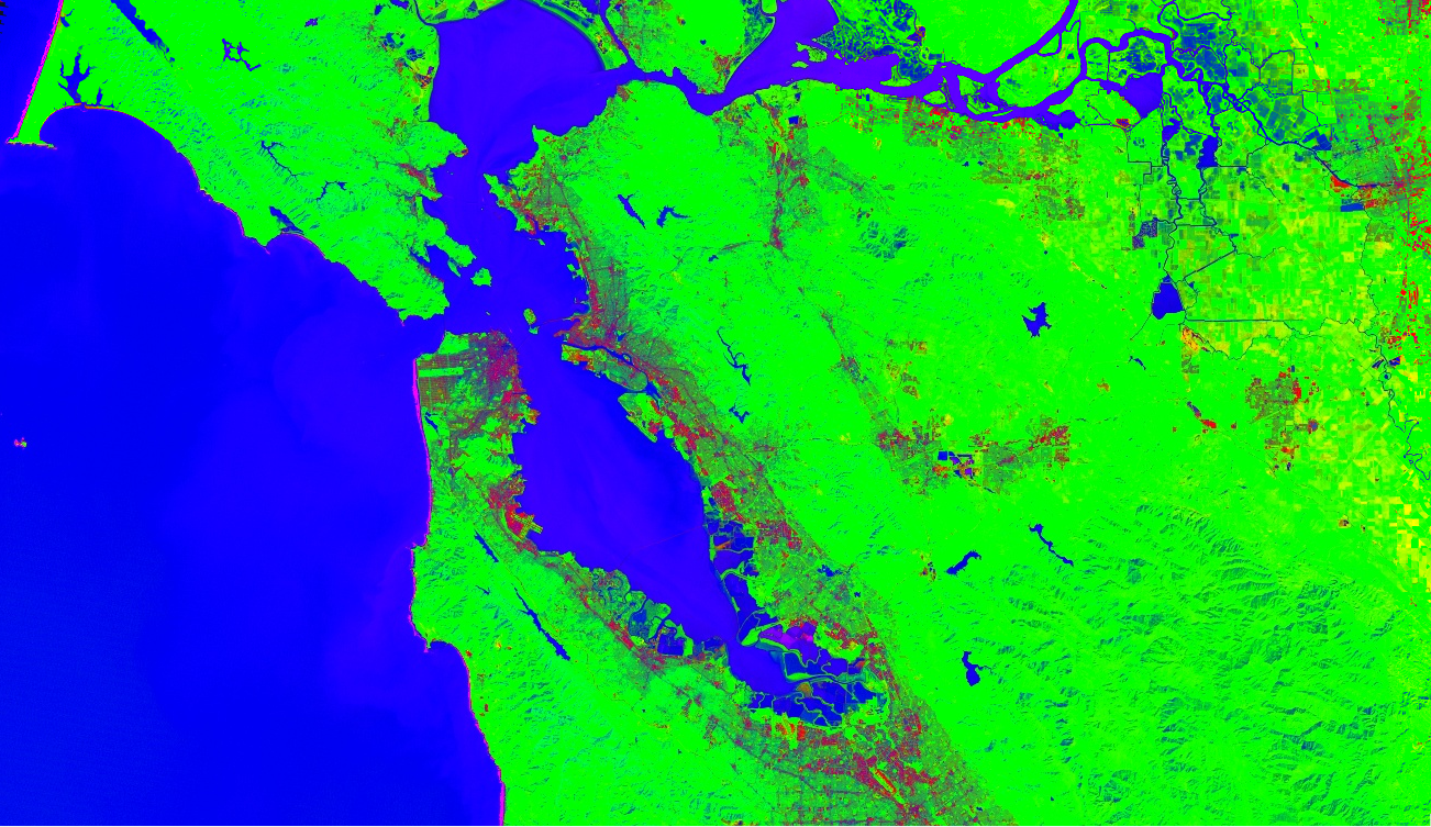
Spektral ayırma
Spektral spektral ayırma, Earth Engine'da image.unmix() yöntemi olarak uygulanır.
(Daha esnek yöntemler için Dizi Dönüşümleri sayfasına bakın). Aşağıda, Landsat 5'in önceden belirlenmiş kentsel, bitki örtüsü ve su uç üyeleriyle birlikte çözülmesine dair bir örnek verilmiştir:
Kod Düzenleyici (JavaScript)
// Load a Landsat 5 image and select the bands we want to unmix.
var bands = ['B1', 'B2', 'B3', 'B4', 'B5', 'B6', 'B7'];
var image = ee.Image('LANDSAT/LT05/C02/T1/LT05_044034_20080214')
  .select(bands);
Map.setCenter(-122.1899, 37.5010, 10); // San Francisco Bay
Map.addLayer(image, {bands: ['B4', 'B3', 'B2'], min: 0, max: 128}, 'image');

// Define spectral endmembers.
var urban = [88, 42, 48, 38, 86, 115, 59];
var veg = [50, 21, 20, 35, 50, 110, 23];
var water = [51, 20, 14, 9, 7, 116, 4];

// Unmix the image.
var fractions = image.unmix([urban, veg, water]);
Map.addLayer(fractions, {}, 'unmixed');
import ee
import geemap.core as geemap
Colab (Python)
# Load a Landsat 5 image and select the bands we want to unmix.
bands = ['B1', 'B2', 'B3', 'B4', 'B5', 'B6', 'B7']
image = ee.Image('LANDSAT/LT05/C02/T1/LT05_044034_20080214').select(bands)

# Define spectral endmembers.
urban = [88, 42, 48, 38, 86, 115, 59]
veg = [50, 21, 20, 35, 50, 110, 23]
water = [51, 20, 14, 9, 7, 116, 4]

# Unmix the image.
fractions = image.unmix([urban, veg, water])

# Define a map centered on San Francisco Bay.
map_fractions = geemap.Map(center=[37.5010, -122.1899], zoom=10)

# Add the image layers to the map and display it.
map_fractions.add_layer(
    image, {'bands': ['B4', 'B3', 'B2'], 'min': 0, 'max': 128}, 'image'
)
map_fractions.add_layer(fractions, None, 'unmixed')
display(map_fractions)