عرض المصدر على GitHub
هناك عدة طرق للتحويل الطيفي في Earth Engine. وتشمل هذه الطرق
طرق إنشاء النماذج على الصور، مثل normalizedDifference() وunmix()
rgbToHsv() وhsvToRgb().
تحسين جودة اللقطات الشاملة
تعمل ميزة "توضيح الصورة الشاملة" على تحسين دقة صورة متعددة النطاقات من خلال
التحسين الذي تقدّمه صورة شاملة ملونة ذات دقة أعلى.
تكون الطريقتان rgbToHsv() وhsvToRgb() مفيدة لتحسين حدة اللقطات المتحرّكة.
محرِّر الرموز البرمجية (JavaScript)
// Load a Landsat 8 top-of-atmosphere reflectance image.
var image = ee.Image('LANDSAT/LC08/C02/T1_TOA/LC08_044034_20140318');
Map.addLayer(
    image,
    {bands: ['B4', 'B3', 'B2'], min: 0, max: 0.25, gamma: [1.1, 1.1, 1]},
    'rgb');

// Convert the RGB bands to the HSV color space.
var hsv = image.select(['B4', 'B3', 'B2']).rgbToHsv();

// Swap in the panchromatic band and convert back to RGB.
var sharpened = ee.Image.cat([
  hsv.select('hue'), hsv.select('saturation'), image.select('B8')
]).hsvToRgb();

// Display the pan-sharpened result.
Map.setCenter(-122.44829, 37.76664, 13);
Map.addLayer(sharpened,
             {min: 0, max: 0.25, gamma: [1.3, 1.3, 1.3]},
             'pan-sharpened');
import ee
import geemap.core as geemap
Colab (Python)
# Load a Landsat 8 top-of-atmosphere reflectance image.
image = ee.Image('LANDSAT/LC08/C02/T1_TOA/LC08_044034_20140318')

# Convert the RGB bands to the HSV color space.
hsv = image.select(['B4', 'B3', 'B2']).rgbToHsv()

# Swap in the panchromatic band and convert back to RGB.
sharpened = ee.Image.cat(
    [hsv.select('hue'), hsv.select('saturation'), image.select('B8')]
).hsvToRgb()

# Define a map centered on San Francisco, California.
map_sharpened = geemap.Map(center=[37.76664, -122.44829], zoom=13)

# Add the image layers to the map and display it.
map_sharpened.add_layer(
    image,
    {
        'bands': ['B4', 'B3', 'B2'],
        'min': 0,
        'max': 0.25,
        'gamma': [1.1, 1.1, 1],
    },
    'rgb',
)
map_sharpened.add_layer(
    sharpened,
    {'min': 0, 'max': 0.25, 'gamma': [1.3, 1.3, 1.3]},
    'pan-sharpened',
)
display(map_sharpened)
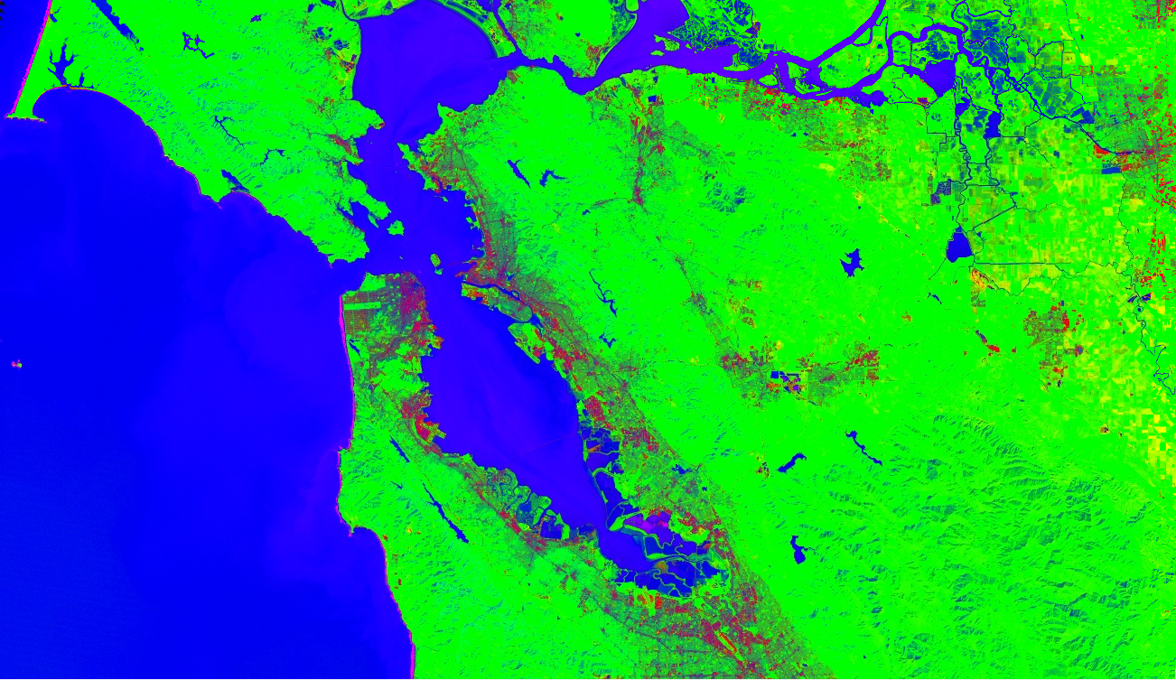
فصل الأطياف
يتم تنفيذ تقنية "الفصل الطيفي" في Earth Engine كطريقة image.unmix().
(للاطّلاع على طرق أكثر مرونة، يُرجى الاطّلاع على صفحة "تحويلات الصفيف"). في ما يلي مثال على إزالة المزج في صور Landsat 5 باستخدام عناصر نهائية مُحدَّدة مسبقًا للمناطق الحضرية
والنباتات والمياه:
محرِّر الرموز البرمجية (JavaScript)
// Load a Landsat 5 image and select the bands we want to unmix.
var bands = ['B1', 'B2', 'B3', 'B4', 'B5', 'B6', 'B7'];
var image = ee.Image('LANDSAT/LT05/C02/T1/LT05_044034_20080214')
  .select(bands);
Map.setCenter(-122.1899, 37.5010, 10); // San Francisco Bay
Map.addLayer(image, {bands: ['B4', 'B3', 'B2'], min: 0, max: 128}, 'image');

// Define spectral endmembers.
var urban = [88, 42, 48, 38, 86, 115, 59];
var veg = [50, 21, 20, 35, 50, 110, 23];
var water = [51, 20, 14, 9, 7, 116, 4];

// Unmix the image.
var fractions = image.unmix([urban, veg, water]);
Map.addLayer(fractions, {}, 'unmixed');
import ee
import geemap.core as geemap
Colab (Python)
# Load a Landsat 5 image and select the bands we want to unmix.
bands = ['B1', 'B2', 'B3', 'B4', 'B5', 'B6', 'B7']
image = ee.Image('LANDSAT/LT05/C02/T1/LT05_044034_20080214').select(bands)

# Define spectral endmembers.
urban = [88, 42, 48, 38, 86, 115, 59]
veg = [50, 21, 20, 35, 50, 110, 23]
water = [51, 20, 14, 9, 7, 116, 4]

# Unmix the image.
fractions = image.unmix([urban, veg, water])

# Define a map centered on San Francisco Bay.
map_fractions = geemap.Map(center=[37.5010, -122.1899], zoom=10)

# Add the image layers to the map and display it.
map_fractions.add_layer(
    image, {'bands': ['B4', 'B3', 'B2'], 'min': 0, 'max': 128}, 'image'
)
map_fractions.add_layer(fractions, None, 'unmixed')
display(map_fractions)