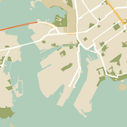
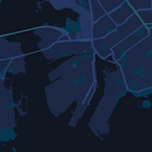
Questa pagina è una guida rapida per applicare uno stile alla mappa, utilizzando la modalità notturna come esempio.
Panoramica
Con le opzioni di stile puoi personalizzare la presentazione degli stili standard di Google Maps, modificando la visualizzazione di elementi come strade, parchi, attività e altri punti di interesse. Ciò significa che puoi enfatizzare
componenti particolari della mappa o fare in modo che la mappa si adatti allo stile della tua
app.
Lo stile funziona solo con il tipo di mappa kGMSTypeNormal.
Applicare stili alla mappa
Per applicare stili di mappa personalizzati a una mappa, chiama GMSMapStyle(...) per creare un'istanza di GMSMapStyle, passando un URL per un file JSON locale o una stringa JSON contenente le definizioni di stile. Assegna l'istanza GMSMapStyle alla proprietà
mapStyle della mappa.
Utilizzare un file JSON
Gli esempi seguenti mostrano la chiamata a GMSMapStyle(...) e il passaggio di un URL per un file locale:
Swift
importGoogleMapsclassMapStyling:UIViewController{// Set the status bar style to complement night-mode.overridevarpreferredStatusBarStyle:UIStatusBarStyle{return.lightContent}overridefuncloadView(){letcamera=GMSCameraPosition.camera(withLatitude:-33.86,longitude:151.20,zoom:14.0)letmapView=GMSMapView.map(withFrame:CGRect.zero,camera:camera)do{// Set the map style by passing the URL of the local file.ifletstyleURL=Bundle.main.url(forResource:"style",withExtension:"json"){mapView.mapStyle=tryGMSMapStyle(contentsOfFileURL:styleURL)}else{NSLog("Unable to find style.json")}}catch{NSLog("One or more of the map styles failed to load. \(error)")}self.view=mapView}}
Objective-C
#import "MapStyling.h"@importGoogleMaps;@interfaceMapStyling()@end@implementationMapStyling// Set the status bar style to complement night-mode.-(UIStatusBarStyle)preferredStatusBarStyle{returnUIStatusBarStyleLightContent;}-(void)loadView{GMSCameraPosition*camera=[GMSCameraPositioncameraWithLatitude:-33.86longitude:151.20zoom:12];GMSMapView*mapView=[GMSMapViewmapWithFrame:CGRectZerocamera:camera];mapView.myLocationEnabled=YES;NSBundle*mainBundle=[NSBundlemainBundle];NSURL*styleUrl=[mainBundleURLForResource:@"style"withExtension:@"json"];NSError*error;// Set the map style by passing the URL for style.json.GMSMapStyle*style=[GMSMapStylestyleWithContentsOfFileURL:styleUrlerror:&error];if(!style){NSLog(@"The style definition could not be loaded: %@",error);}mapView.mapStyle=style;self.view=mapView;}@end
Per definire le opzioni di stile, aggiungi un nuovo file al progetto denominato style.json
e incolla la seguente dichiarazione di stile JSON per lo stile della modalità notturna:
Gli esempi seguenti mostrano la chiamata di GMSMapStyle(...) e il passaggio di una risorsa stringa:
Swift
classMapStylingStringResource:UIViewController{letMapStyle="JSON_STYLE_GOES_HERE"// Set the status bar style to complement night-mode.overridevarpreferredStatusBarStyle:UIStatusBarStyle{return.lightContent}overridefuncloadView(){letcamera=GMSCameraPosition.camera(withLatitude:-33.86,longitude:151.20,zoom:14.0)letmapView=GMSMapView.map(withFrame:CGRect.zero,camera:camera)do{// Set the map style by passing a valid JSON string.mapView.mapStyle=tryGMSMapStyle(jsonString:MapStyle)}catch{NSLog("One or more of the map styles failed to load. \(error)")}self.view=mapView}}
Objective-C
@implementationMapStylingStringResource// Paste the JSON string to use.staticNSString*constkMapStyle=@"JSON_STYLE_GOES_HERE";// Set the status bar style to complement night-mode.-(UIStatusBarStyle)preferredStatusBarStyle{returnUIStatusBarStyleLightContent;}-(void)loadView{GMSCameraPosition*camera=[GMSCameraPositioncameraWithLatitude:-33.86longitude:151.20zoom:12];GMSMapView*mapView=[GMSMapViewmapWithFrame:CGRectZerocamera:camera];mapView.myLocationEnabled=YES;NSError*error;// Set the map style by passing a valid JSON string.GMSMapStyle*style=[GMSMapStylestyleWithJSONString:kMapStyleerror:&error];if(!style){NSLog(@"The style definition could not be loaded: %@",error);}mapView.mapStyle=style;self.view=mapView;}@end
Per definire le opzioni di stile, incolla la seguente stringa di stile come valore della variabile kMapStyle:
Le mappe con stili utilizzano due concetti per applicare colori e altre modifiche di stile a una
mappa:
I selettori specificano i componenti geografici a cui puoi applicare uno stile sulla mappa. Questi includono strade, parchi, specchi d'acqua e
altro ancora, nonché le relative etichette. I selettori includono funzionalità
ed elementi, specificati come proprietà featureType e
elementType.
Gli stili sono proprietà di colore e visibilità che puoi
applicare agli elementi della mappa. Definiscono il colore visualizzato tramite una
combinazione di valori di tonalità, colore, luminosità e gamma.
Consulta il riferimento allo stile per una descrizione dettagliata delle opzioni di stile JSON.
Utilizza la
procedura guidata degli stili di Maps Platform
come modo rapido per generare un oggetto di stile JSON. L'SDK Maps per iOS
supporta le stesse dichiarazioni di stile dell'API Maps JavaScript.
Esempi di codice completi
Il
repository ApiDemos
su GitHub include esempi che dimostrano l'utilizzo degli stili.
[[["Facile da capire","easyToUnderstand","thumb-up"],["Il problema è stato risolto","solvedMyProblem","thumb-up"],["Altra","otherUp","thumb-up"]],[["Mancano le informazioni di cui ho bisogno","missingTheInformationINeed","thumb-down"],["Troppo complicato/troppi passaggi","tooComplicatedTooManySteps","thumb-down"],["Obsoleti","outOfDate","thumb-down"],["Problema di traduzione","translationIssue","thumb-down"],["Problema relativo a esempi/codice","samplesCodeIssue","thumb-down"],["Altra","otherDown","thumb-down"]],["Ultimo aggiornamento 2026-05-31 UTC."],[],["To customize map appearance, apply styles to the `kGMSTypeNormal` map type. Utilize `GMSMapStyle` by passing a URL for a local JSON file or a JSON string to the `mapStyle` property. Define styles with selectors (features and elements) and stylers (color, visibility). Create a `style.json` file for night-mode styling with the provided JSON or use a JSON string directly. Consider cloud customization for uniform styling across multiple apps. The Maps Platform Styling Wizard can help generate JSON style objects. Avoid mixing cloud and hardcoded styles.\n"]]