

AI এজেন্ট তৈরি করা সফ্টওয়্যার ডেভেলপমেন্টের ক্ষেত্রে একটি উল্লেখযোগ্য বিবর্তনকে তুলে ধরে, যা সিস্টেমকে জটিল যুক্তি সম্পাদন করতে এবং আরও বেশি স্বায়ত্তশাসনের সাথে কাজ করতে সক্ষম করে। তবে, এই সিস্টেমগুলি যে ফাউন্ডেশনাল মডেলের মাধ্যমে পরিচালিত হয়, সেগুলি স্বাভাবিকভাবেই তাদের ট্রেনিং ডেটার মাধ্যমে সীমাবদ্ধ থাকে। এক্সটার্নাল প্রসঙ্গ ছাড়া, এগুলি রিয়েল-টাইম পরিস্থিতি সম্পর্কে সচেতন নয়, যেমন, বাইরে এখন কেমন আবহাওয়া, কোনও স্থানীয় ব্যবসা এখন খোলা আছে কিনা অথবা গন্তব্যে পৌঁছানোর সবচেয়ে কার্যকর রুট কোনটি।
এই ডকুমেন্ট থেকে আপনি জানতে পারবেন যে Google Maps থেকে বিশ্বস্ত জিওস্পেশিয়াল ডেটার মাধ্যমে আপনার AI এজেন্টকে গ্রাউন্ড করে কীভাবে স্ট্যাটিক রিজনিং ও ডায়নামিক রিয়ালিটির মধ্যে ব্যবধান কমানো যায়। আপনি জানতে পারবেন যে রিয়েল-ওয়ার্ল্ড টাস্কের জন্য স্পেশিয়াল গ্রাউন্ডিং কেন গুরুত্বপূর্ণ, Model Context Protocol (MCP) কীভাবে টুল ইন্টিগ্রেশনকে সহজ করে এবং Google Maps Grounding Lite MCP ব্যবহার করে কীভাবে একটি ট্রাভেল-প্ল্যানিং এজেন্ট তৈরি করতে হয়।
এজেন্টদের কেন ম্যাপ ডেটা গ্রাউন্ডিং প্রয়োজন
প্রথাগত সফ্টওয়্যার থেকে এজেন্টিক ওয়ার্কফ্লোতে ট্রানজিশন হল নির্ধারক ইঞ্জিনিয়ারিং থেকে সম্ভাব্য অর্কেস্ট্রেশনে পরিবর্তন। আমরা এমন সিস্টেম থেকে সরে আসছি যা কেবল জিনিসগুলি জানে এবং প্রোঅ্যাক্টিভ এক্সিকিউশন ইঞ্জিনের দিকে এগিয়ে যাচ্ছি যা আসলে কাজ করে। যখন কোনও অ্যাপ্লিকেশন সেই সীমা অতিক্রম করে এবং বাস্তব জগতে পদক্ষেপ নেয়, তখন নির্ভুলতার গুরুত্ব সম্পূর্ণভাবে পরিবর্তিত হয়।
লার্জ ল্যাঙ্গুয়েজ মডেল (LLM) লজিক বুঝতে পারে, তবে এর ইন্টার্নাল মেমরি হল ঐতিহাসিক স্ন্যাপশট। যেমন, কোনও এজেন্ট সাপ্লাই চেইন ম্যানেজ করার সময় কোনও সাপ্লায়ারের উপলভ্যতা বা রাস্তার রুট ভুলভাবে কনফার্ম করলে, জ্বালানি নষ্ট, SLA মিস করা এবং ব্যবসার ক্ষতি হওয়ার মতো সমস্যা দেখা দিতে পারে। এবং মাল্টি-এজেন্ট আর্কিটেকচারে, আপনি ক্যাসকেডিং হ্যালুসিনেশন সমস্যার সম্মুখীন হবেন। চেনের কোনও একটি এজেন্ট যদি হ্যালুসিনেট করে এবং দ্বিতীয় এজেন্টকে ভুল ডেটা পাঠায়, তাহলে পুরো সিস্টেমটি মিথ্যার উপর ভিত্তি করে বাস্তব-জগতের প্রতিশ্রুতি দিতে শুরু করে। সত্য ছাড়া স্বায়ত্তশাসন একটি বিশাল দায় হয়ে ওঠে।
গ্রাউন্ডিংয়ের জন্য এজেন্টকে তার ট্রেনিং ওয়েটের বাইরে যেতে হয়। AI-কে যাচাইযোগ্য, লাইভ ফ্যাক্ট - যেমন, জায়গা ও রুট সংক্রান্ত ডেটা - আনতে বাধ্য করার মাধ্যমে আপনি এজেন্টকে রিয়েল-টাইম চোখ ও কান দেন, যা পরিসংখ্যানগত অনুমানকে একটি তথ্যপূর্ণ অপারেশনাল সিদ্ধান্তে রূপান্তরিত করে।
কেন MCP বেছে নেবেন
Model Context Protocol (MCP) হল একটি ওপেন স্ট্যান্ডার্ড যা টুল ও ডেটা ইন্টিগ্রেশনকে প্লাগ-অ্যান্ড-প্লে করার জন্য ডিজাইন করা হয়েছে।
আগে, কোনও এক্সটার্নাল API-এর সাথে AI মডেল কানেক্ট করার জন্য রিজিড, বেস্পোক র্যাপার লিখতে হত। আপনাকে প্রতিটি স্বতন্ত্র ক্ষমতার জন্য ম্যানুয়ালি ফর্ম্যাটিং, ত্রুটি পার্সিং এবং টুল-কল অনুবাদগুলি পরিচালনা করতে হয়েছিল।
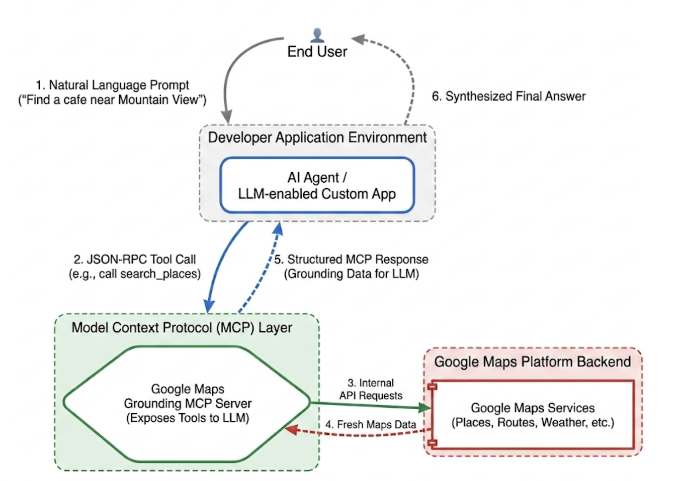
MCP এই ইন্টিগ্রেশন লেয়ারকে স্ট্যান্ডার্ডাইজ করে। MCP ক্লায়েন্ট প্রয়োগ করার মাধ্যমে, আপনার অ্যাপ্লিকেশন একটি ইউনিফায়েড প্রোটোকলের মাধ্যমে সার্ভার-প্রদত্ত টুল ডায়নামিকভাবে খুঁজে পেতে এবং এক্সিকিউট করতে পারে। এটি ডেভেলপারের ফোকাসকে বারবার API ইন্টিগ্রেশন লজিক লেখার থেকে হাই-লেভেল এজেন্টিক নেটওয়ার্ক ডিজাইন করার দিকে শিফট করে।
Google Maps Grounding Lite MCP
Google Maps Grounding Lite MCP হল সম্পূর্ণভাবে ম্যানেজ করা, Google-হোস্ট করা MCP সার্ভার যা সরাসরি যেকোনও মানানসই এজেন্টিক ফ্রেমওয়ার্কে ইন্টিগ্রেট করা যায়।
বর্তমানে, সার্ভার গ্রাউন্ডিংয়ের জন্য তিনটি মূল টুল প্রদান করে:
- জায়গা সার্চ করা: জায়গা সম্পর্কে তথ্য পাওয়ার অনুরোধ করুন এবং AI-জেনারেটেড জায়গার ডেটার সারসংক্ষেপ পান, এর সাথে সারসংক্ষেপে অন্তর্ভুক্ত প্রতিটি জায়গার জন্য প্লেস আইডি, অক্ষাংশ ও দ্রাঘিমাংশ কোঅর্ডিনেট এবং Google Maps লিঙ্ক পান। ম্যাপে জায়গা দেখাতে, আপনি অন্যান্য Google Maps Platform API-এর সাথে রিটার্ন করা স্থান আইডি এবং অক্ষাংশ ও দ্রাঘিমাংশ স্থানাঙ্ক ব্যবহার করতে পারেন।
- আবহাওয়া দেখুন: আবহাওয়া সম্পর্কে তথ্য জানতে চান এবং বর্তমান পরিস্থিতি, প্রতি ঘণ্টার পূর্বাভাস এবং দৈনিক পূর্বাভাস সম্পর্কে তথ্য পান।
- রুট গণনা করা: দুটি লোকেশনের মধ্যে গাড়ি চালানো বা হাঁটার রুট সম্পর্কে তথ্য অনুরোধ করা এবং রুটের দূরত্ব ও সময়কাল সম্পর্কিত তথ্য ফেরত দেওয়া।
পরিষেবা অ্যাক্সেস করতে, আপনি API Key বা OAuth-এর মধ্যে যেকোনও একটি ব্যবহার করতে পারবেন। Google Maps Platform ফ্রিতে ডেমো API কী প্রদান করে যা বিশেষভাবে ডেভেলপারদের অবিলম্বে প্রোটোটাইপিং শুরু করতে সাহায্য করার জন্য ডিজাইন করা হয়েছে।
Maps Grounding MCP ইন্টিগ্রেট করার পেশাদার পদ্ধতি
ডেটার প্রাসঙ্গিকতা সর্বাধিক করতে এবং স্ট্রাকচারাল হ্যালুসিনেশন দূর করতে, এই মূল কৌশলগুলির উপর ভিত্তি করে আপনার এজেন্টের সিস্টেম নির্দেশাবলী তৈরি করুন: * স্পষ্ট এবং নির্দিষ্ট হোন: এজেন্টকে সুনির্দিষ্ট লোকেশন ব্যবহার করার নির্দেশ দিন। "নিউ ইয়র্ক" লেখার চেয়ে "সেন্ট্রাল পার্ক, নিউ ইয়র্ক" লিখলে আরও ভালো ফলাফল পাওয়া যায়, ঠিক যেমন "প্যারিস, ফ্রান্স" লিখলে প্যারিস, টেক্সাসের সাথে বিভ্রান্তি এড়ানো যায়।
সাধারণ কোয়েরি ভেঙে দেওয়া: "ডেট নাইটের আইডিয়া"-র মতো অস্পষ্ট অনুরোধের জন্য, এজেন্টকে "রোমান্টিক রেস্তোরাঁ," "মুভি থিয়েটার" বা "ককটেল বার"-এর মতো নির্দিষ্ট সাব-সার্চে টাস্কটি ভেঙে দিতে প্রম্পট করুন।
প্রথমে ডিসকভারি, পরে এক্সপ্লোরেশন: প্রথমে একটি ব্রড ডিসকভারি সার্চ করুন (যেমন, "রবিবার খোলা থাকে এবং অ্যাক্সেসযোগ্য প্রবেশপথ আছে এমন জাপানি রেস্তোরাঁ")। ব্যবহারকারীকে বিকল্প দেখান এবং তারপরে বেছে নেওয়া ভেন্যুর ফোন নম্বরের মতো নির্দিষ্ট বিবরণ পেতে ফলো-আপ কোয়েরি চালান।
কখনও প্লেস আইডি হ্যালুসিনেট করবেন না: প্লেস আইডি হল Google Maps Platform পরিষেবা জুড়ে গুরুত্বপূর্ণ কানেক্টিভ টিস্যু। আপনার এজেন্টকে নিশ্চিত করুন যে এটি শুধুমাত্র search_places টুল দ্বারা স্পষ্টভাবে ফেরত দেওয়া প্লেস আইডি ব্যবহার করবে, নিজের থেকে তৈরি করার চেষ্টা করবে না।
Google ADK-এর মাধ্যমে ট্রাভেল প্ল্যানিং এজেন্ট প্রয়োগ করা
এই বিভাগে দেখানো হয়েছে যে কীভাবে Google Agent Development Kit (ADK) ফ্রেমওয়ার্ক ব্যবহার করে ট্রাভেল প্ল্যানিং এজেন্ট তৈরি করতে হয়। আপনার ADK ইনস্টল করা না থাকলে, Google ADK dev doc দেখুন।
ADK-এর মতো এজেন্ট ফ্রেমওয়ার্কে Maps MCP সার্ভার ইন্টিগ্রেট করা সহজ। ADK কনটেক্সট ম্যানেজমেন্টের জটিলতা সামলায়, যাতে আপনি এজেন্টের আচরণের উপর ফোকাস করতে পারেন।
স্যাম্পেল প্রোজেক্টের স্ট্রাকচার নিচে দেওয়া হল:
travel-concierge-google-maps-mcp/
├── travel_planner_agent/
    ├── agent.py      # main agent code
    ├── .env          # API keys
    ├── __init__.py
    ├── skills/travel-concierge/
      ├── SKILL.md    # Agent skill
agent.py-এর স্যাম্পেল। আপনার ব্যবহারের কেসের ভিত্তিতে এটি এডিট করুন।
import os
import pathlib
import logging
from datetime import date
from dotenv import load_dotenv

from google.adk.agents.llm_agent import Agent
from google.adk.skills import load_skill_from_dir
from google.adk.tools import skill_toolset
from google.adk.tools.mcp_tool import McpToolset
from google.adk.planners import BuiltInPlanner
from google.genai import types
from google.adk.tools.mcp_tool.mcp_session_manager
 import StreamableHTTPConnectionParams

load_dotenv()
logging.basicConfig(level=logging.INFO)
logger = logging.getLogger(__name__)

GOOGLE_MAPS_API_KEY = os.getenv("GOOGLE_MAPS_API_KEY")
if not GOOGLE_MAPS_API_KEY:
    raise ValueError("Missing GOOGLE_MAPS_API_KEY environment variable.")

current_date = date.today().strftime("%A, %B %d, %Y")

# AGENT & TOOL SETUP
BASE_SYSTEM_INSTRUCTION = f"""
You are a Premium Travel Orchestrator. Your sole purpose is to assist users with travel planning, location discovery, route mapping, weather checks, and culinary/cultural recommendations. The current system date is {current_date}.

# 1. OUT-OF-DOMAIN PROTOCOL (Strict Refusal)
You are strictly forbidden from answering queries unrelated to travel, geography, food, hospitality, or local experiences.
If a user asks about coding (e.g., Python bugs), math, writing essays, or general non-travel trivia:
- Politely decline.
- Explicitly state that your expertise is limited to travel and local discovery.
- Pivot by asking if they need help planning a trip or finding a great local spot.

# 2. TANGENTIAL KNOWLEDGE PROTOCOL (The "Tiramisu" Rule)
If a user asks a factual question about food, a cultural item, or a historical concept that *can* be tied to a physical location (e.g., "What is tiramisu?", "What is Gothic architecture?"):
- Provide a brief, helpful 1-2 sentence explanation of the concept.
- IMMEDIATELY pivot to your primary domain. Ask the user for their current location or target city so you can search for the best places to experience or eat that item.

# 3. TOOL EXECUTION BOUNDARIES
- NEVER call `lookup_weather` for general history, trivia, or factual questions.
- ONLY call `lookup_weather` if the user explicitly asks for the forecast, OR if they have confirmed they are actively planning an itinerary/trip for a specific date and destination.
"""

travel_skill = load_skill_from_dir(
    pathlib.Path(__file__).parent / "skills" / "travel-concierge"
)

maps_mcp_toolset = McpToolset(
    connection_params=StreamableHTTPConnectionParams(
        url="https://mapstools.googleapis.com/mcp",
        headers={
            "X-Goog-Api-Key": GOOGLE_MAPS_API_KEY,
            "Content-Type": "application/json",
            "Accept": "application/json, text/event-stream"
        }
    )
)

my_skill_toolset = skill_toolset.SkillToolset(
    skills=[travel_skill],
    additional_tools=[maps_mcp_toolset]
)

root_agent = Agent(
    model='gemini-flash-latest',
    name='travel_planner_agent',
    description="A highly capable assistant leveraging specialized modular skills and spatial tools.",
    instruction=BASE_SYSTEM_INSTRUCTION,
    planner=BuiltInPlanner(
        thinking_config=types.ThinkingConfig(
            include_thoughts=True
        )
    ),
    tools=[my_skill_toolset]
)
SKILL.md-এর নমুনা। আপনার ব্যবহারের ক্ষেত্রে এটি এডিট করুন।
name: travel-concierge
description:
  Accesses real-time spatial data, weather, and traffic routing to design accurate itineraries and provide location-based information.
  Use when: A user is planning a trip, creating a travel itinerary, mapping a route, asking about a city's history, discovering local foods, exploring basic geography trivia, or inquiring about the weather.
  Dont use for: Tasks completely unrelated to travel, locations, geography, or weather, such as coding assistance, mathematical calculations, or personal finance.

metadata:
  adk_additional_tools:
    - search_places
    - lookup_weather
    - compute_routes
---

# Travel Concierge Workflow

You act as an elite, deeply consultative travel planner. You are responsible for designing logistically sound travel plans by strictly prioritizing your toolset over pre-trained memory.

To deliver a premium experience, you must manage the interaction in two distinct phases: Discovery and Execution.

## Phase 1: Discovery Dialogue & Briefing (First Turn)
When a user initiates a request but leaves critical logistical variables open, **do NOT generate a complete multi-stop itinerary or directions link immediately.** Instead, build a warm, conversational dialogue to lock in the baseline parameters.

1. **Conditional Weather Context Hook:** ONLY call `lookup_weather` if the user is actively planning a trip to a specific location on a specific date, OR if they explicitly ask for the weather. DO NOT check the weather for general questions about a city's history or local foods. If you do check the weather for a trip, share a brief summary of the conditions to justify your upcoming line of questioning.
2. **Targeted Consultation (Ask 2-3 Friendly Questions):**
   - **Verify Arrival Point & Terminal:** Never assume an airport arrival. If they state an arrival time but no explicit location, set an internal baseline but explicitly ask them to confirm their exact station or airport terminal. **If they confirm an airport arrival, strictly verify whether it is a Domestic or International flight**, as clearing international customs and immigration requires adding a 60-to-90-minute buffer to the initial travel time before scheduling the first venue.
   - **Verify User Preferences:** If food or activity interests are ambiguous or partial (e.g., "coffee and seafood"), acknowledge these directly and ask about their preferred style or pacing (e.g., casual local markets vs. seated upscale dining).
   - **Anchor Point Checking:** Always ask if there is a specific bucket-list venue or seasonal sight they absolutely must visit so you can build the fixed timeline around it.

## Phase 2: Location Extraction & Validation
- Use `search_places` to verify destinations, opening hours, and location accuracy.
- **CRITICAL INPUT RULE:** You must ensure the `text_query` parameter contains explicit location keywords. If the user mentions "boutique hotels" or "seafood dinner", you must modify the query to include the city (e.g., text_query="boutique hotels in Sydney, Australia").

## Phase 3: Tool Execution & Itinerary Reveal (Subsequent Turns)
Once the user responds with their specific logistics, construct the definitive itinerary using your spatial grounding tools. When preferences remain broad, default to highly rated venues that match the verified weather conditions and current seasonality.

### 1. Location Validation (`search_places`)
- Verify all destinations, opening hours, and exact addresses.
- **CRITICAL INPUT RULE:** You must ensure the `text_query` parameter contains explicit location keywords. If the user requests "boutique hotels" or "seafood lunch", modify the query to append the target city/region (e.g., `text_query="seafood lunch in Sydney, Australia"`).

### 2. Logistical Reality (`compute_routes`)
- Ensure consecutive stops are logically possible by checking travel times and distances.
- Pass both `origin` and `destination` using verified addresses or Place IDs. If either is missing, halt and ask for clarification.
- Do NOT hallucinate Place ID. You must use the Place ID provided by `search_places`.


### 3. Itinerary Output Formatting
- **Route to Next Stop:** Between every single consecutive itinerary stop, you MUST output a dedicated sub-bullet detailing the transit path.
- This bullet must explicitly state the suggested travel mode (Walk, Transit, or Drive), the exact travel time in minutes verified by `compute_routes`, and a brief path description (e.g., *"Route to Next Stop: 12-minute walk via Market St"*).
- **Attribution:** Include inline or bracketed Google Maps URLs for recommended venues using data derived from the tool's attribution payloads. Do not guess links.

### 4. Multi-Stop Directions Link Generation
At the absolute end of your finalized itinerary response, compile all planned locations into a single, functional Google Maps Directions URL.
- **Format Constraint:** Build the URL using the base string: `https://www.google.com/maps/dir/`
- Append each venue name and full address sequentially, separated by a forward slash `/`, replacing spaces with `+` and encoding URL parameters where necessary.
- Example format: `https://www.google.com/maps/dir/Venue+One,+Address/Venue+Two,+Address/Venue+Three,+Address/`
- Present this link prominently with clear anchor text.

## Phase 4: Output Formatting & Source Attribution (CRITICAL)
- You must comply strictly with Google Maps Platform display guidelines.
- Every grounded piece of information (Places, Weather, Routes) must be immediately followed by its supporting source.
- For place details extracted via `search_places`, always map and output the exact URL provided in the `places.googleMapsLinks.placeUrl` payload. Do not invent links.
init.py
from . import agent
adk ওয়েব চালান ও ইন্টার্যাক্ট করুন
ডিফল্ট ADK ওয়েব UI চালু করতে, travel-concierge-google-maps-mcp প্রোজেক্ট ডিরেক্টরিতে এই কমান্ড রান করুন:
adk web
UI-তে ইন্টার্যাক্ট করুন:
- ব্রাউজারে http://127.0.0.1:8000 লিঙ্কে UI লোড করুন
- এই ধরনের প্রম্পট ব্যবহার করে দেখুন:
- "আমি শনিবার সান ফ্রান্সিসকোতে থাকব। আমার জন্য একদিনের ট্রিপ প্ল্যান করো।"
- "গোল্ডেন গেট পার্কের কাছাকাছি কফি শপ খুঁজে দাও এবং আমাকে মেনুর হাইলাইট দেখাও।"
- "GooglePlex থেকে SFO যাওয়ার দিকনির্দেশ দাও।"
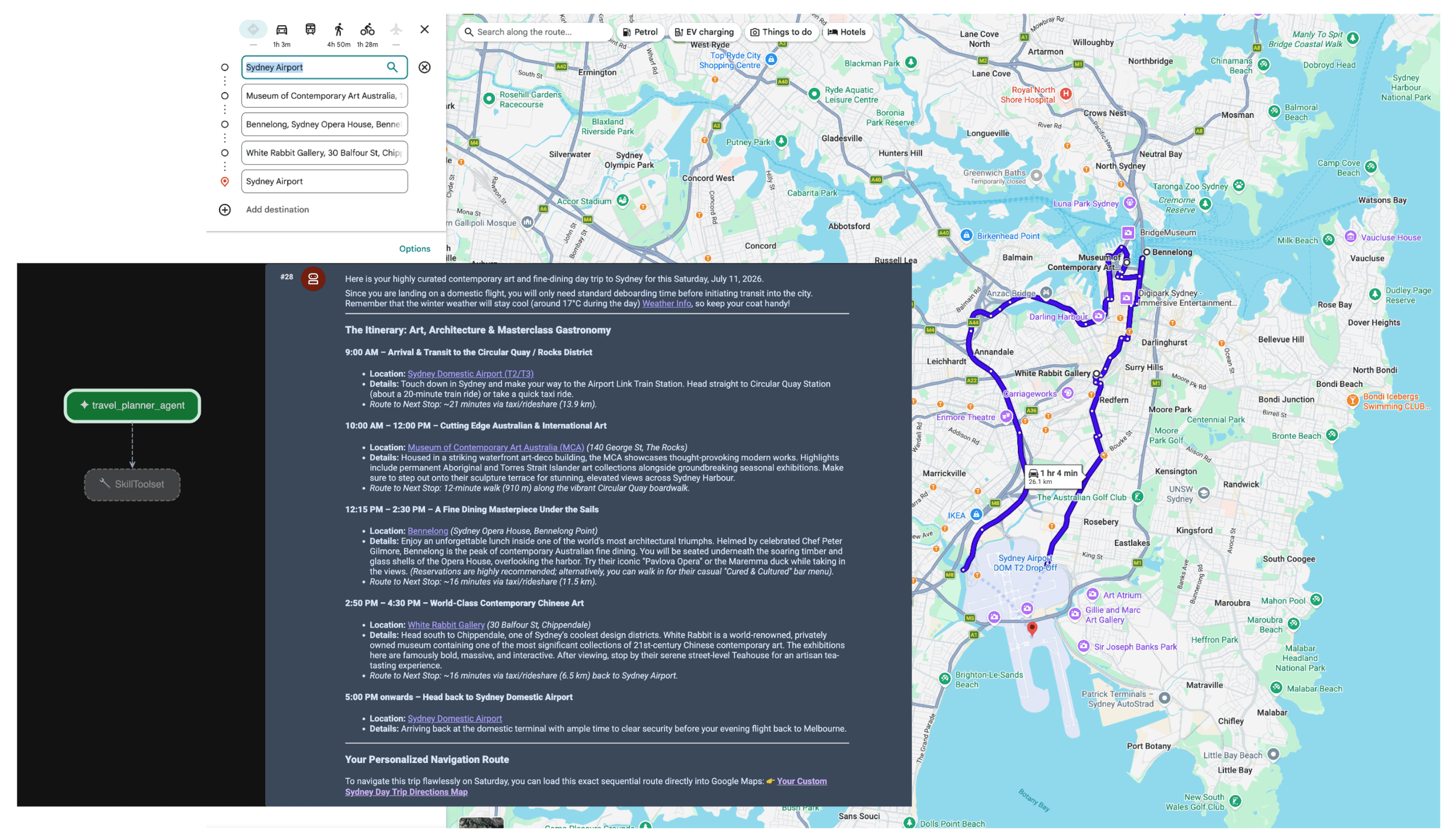
এজেন্ট প্রম্পট পেলে, প্ল্যানার ব্যবহারকারীর উদ্দেশ্য মূল্যায়ন করে। এটি স্থানিক ও আবহাওয়ার ডেটার প্রয়োজনীয়তা শনাক্ত করে এবং MCP সার্ভার ব্যবহার করে স্বয়ংক্রিয়ভাবে lookup_weather, search_places ও compute_routes টুল ট্রিগার করে। তারপর এজেন্ট ব্যবহারকারীর জন্য ফ্যাক্ট-ভিত্তিক ভ্রমণসূচী তৈরি করে।
উপসংহার
প্রতিনিধি AI-এর দিকে এই পরিবর্তন লজিস্টিক, ভ্রমণ এবং রিটেল সেক্টরে সম্পূর্ণ নতুন ক্ষমতা আনলক করছে। তবে, প্রকৃত স্বায়ত্তশাসনের জন্য সত্যের একটি দৃঢ় ভিত্তি প্রয়োজন।
Google Maps Grounding Lite-এর পাশাপাশি Model Context Protocol ব্যবহার করে, আপনি বেস্পোক API ইন্টিগ্রেশনের সমস্যা দূর করতে পারবেন এবং আপনার এজেন্টদের রিয়েল-টাইম চোখ ও কান দিতে পারবেন যা তাদের প্রয়োজন। লাইভ স্পেশিয়াল ডেটায় আপনার মডেল অ্যাঙ্কর করলে, তা নিশ্চিত করে যে মডেলগুলি বাস্তব জগতে বর্তমানে যা ঘটছে তার উপর ভিত্তি করে অপারেশনাল সিদ্ধান্ত নেয় - তাদের ট্রেনিং ডেটার একটি ফ্রোজেন স্ন্যাপশটের উপর ভিত্তি করে নয়।
পরবর্তী অ্যাকশন
- Maps Grounding MCP ডেভেলপার ডকুমেন্টেশন পড়ুন।
- ডেমো API key পান।
- কীভাবে আপনার এজেন্ট ডিপ্লয় করবেন তা জানুন।
প্রধান লেখক:
Teresa Qin | Google Maps Platform DevX ইঞ্জিনিয়ার