
Page Summary
-
Improve the success rate of video renderings in Google Aerial View by validating your address before submitting it.
-
Verify the availability of 3D data for your address in Google Maps by switching to Satellite view and enabling the 3D option.
-
Ensure the accuracy of the property pin on Google Maps, as discrepancies can lead to rendering failures; consider using the "Suggest an edit" feature for corrections.
-
Integrate with the Address Validation API to identify and rectify potential formatting errors or inaccuracies in your address.
-
Be aware that Google's 3D imagery coverage has boundaries and new construction data may take time to be reflected in Aerial View.
We know you're excited to see your property in stunning 3D, and we want to help make sure that the process goes smoothly. This document discusses several techniques you can use to self-validate the quality of your address before submitting it to Google thus improving the overall success rate of video renderings in Aerial View.
When using Google Aerial View API, the first steps is to submit an address to Google. However, on occasion, Google Maps may not have the most up to date address information for a property, or could have trouble interpreting an address depending on how it's formatted. Thus submitting such an address will result in a failure to render the video.
Here are a few things to keep in mind:
- Check if 3D data is available in Google Maps for a particular address
- Check if the property pin on Google Maps is accurate
- Consider any known major renovations. If the building has been renovated recently, it may not have been updated in our 3D database.
- Be aware of 3D data boundaries.
- Make sure your address is formatted correctly. This means including the street name, city, state, and zip code e.g. 1600 Amphitheatre Pkwy, Mountain View, CA 94043
By following these tips, you can help ensure that your address is valid and that the video will be generated successfully.
How to check an address for use with Aerial View API
Check if 3D data is available in Google maps for a particular address
One of the first things you should do is check if Google has 3D data for a particular address.
3D in Google Maps means the map is rendered in three dimensions, not just two. This means that buildings, trees, bridges, and other objects have height and depth, and appear more realistic. Moreover, photorealistic textures are used to make the objects look even more realistic. Here are some examples of what you can see in 3D in Google Maps:
- Buildings with photorealistic textures and heights
- Trees and bridges with height and depth
- Terrain with elevation data
- 3D models of landmarks and other objects
Steps to check if Google has 3D data:
- Open Google Maps in your web browser
- Go to Satellite view
- Click on the 3D icon to the right
- If you do not see 3D data for the address, then Aerial View will not be able to render video for that address.
Please see below an overview of the process:
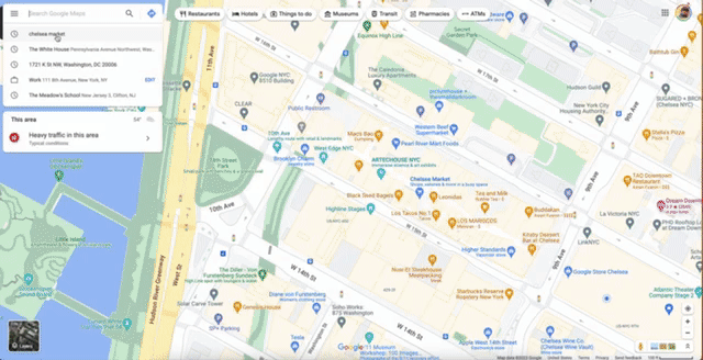
In this case you can clearly see that there is 3D data available for the Chelsea market building in NYC.
Thus when such an address is submitted to Aerial View, it will probably return a successful result.
Check if the property pin on Google maps is accurate
The pin location on Google Maps may not be accurate. This can lead to problems when trying to render videos for buildings.
The pin issue can happen for various data quality reasons. A few things for you to validate:
- If the building has a name. Apartment buildings, office buildings may have official name
- Check if you search on Google Maps using the address and the building name you get the same property
In the above example you can see the pin with the building name is placed on the building whereas the address puts the pin in the courtyard. This type of discrepancy sometimes causes video rendering to fail.

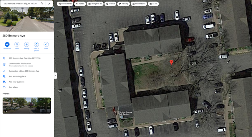
In this more obvious example, we can see the pin of the house is not on any building, rather just on a point on the road.
Aerial View will only render if the address corresponds to a known building.
When submitting an address to Aerial View, always make sure to check the pin location against the address. This is because a building name and a building address may result in different pin locations.
For example, the building name "Empire State Building" may refer to the main building at 350 Fifth Avenue, or it may refer to the entire complex, which includes several other buildings. Similarly, the address "1 World Trade Center" may refer to the main building, or it may refer to the entire complex, which includes several other buildings.
Try to fix the pin location on Google Maps by using the following steps:
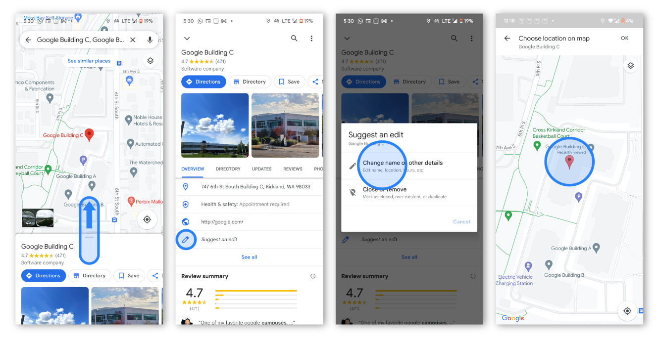
- On your phone or tablet, open the Google Maps app.
- Search for an address.
- Tap Suggest an edit.
- And then Change name or other details.
- Move the map to the center of the building.
- Enter the address information. Then, tap Post.
Validate an address with Address Validation API
Some addresses submitted to Aerial View API may be inaccurate or contain mistakes or may otherwise be unreadable by Google. To avoid errors due to address inaccuracies we recommend integrating with the Address Validation API. Address Validation API helps you validate and correct any mistakes in your address
For example, if the address has a spelling mistake:
1600 Amphitheatre Pkwy, Montan View CA 94043
Address Validation API can correct and provide feedback on what was corrected.
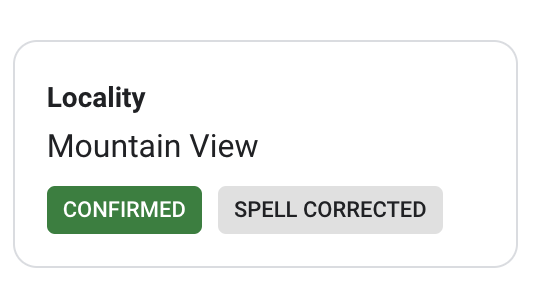
If you submit the formatted address to Aerial View, chances of error due to addresses will reduce.
Be aware of 3D data boundaries
Google's 3D imagery is not available everywhere. By checking 3D data boundaries, you can see where Google has 3D data and where it doesn't. To check 3D data boundaries, go to Google Maps using a web browser on a computer and enter an address or zip code. Then click on the "Layers" button and select "3D View." If 3D data is available for the location, you will see a blue "3D" icon next to the address or zip code. If 3D data is not available, you will see a gray "2D" icon.
Data collection for new constructions take time
Google collects data periodically and the frequency varies by region. This means that new construction data can take a while to be reflected in Google Maps.
However, we add the video_captured_date to the video metadata for Aerial View API. This allows users to see when the images for the video were captured, which can be helpful for determining if the video is up-to-date.
Conclusion
In conclusion, there are a number of things you can do to improve the success rate of address inputs in Aerial View. These include:
- Checking if Google has 3D data for the address
- Ensuring that the pin location is accurate
- Being aware there are 3D data boundaries
- Understanding that data collection for new constructions can take time
By following these tips, you can help ensure that your address inputs in Aerial View are successful.
Suggested Further Reading:
Contributors
Principal author:
Sarthak Ganguly | Google Maps Platform Solutions Engineer