지오데식 도형과 평면 도형 비교
컬렉션을 사용해 정리하기
내 환경설정을 기준으로 콘텐츠를 저장하고 분류하세요.
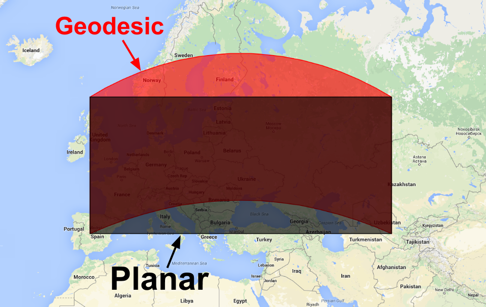
Earth Engine에서 생성된 도형은 지오데시컬 (즉, 가장자리가 구 표면에서 가장 짧은 경로)이거나 평면 (즉, 가장자리가 2D 데카르트 평면에서 가장 짧은 경로)입니다. 전 세계 지형지물 모음에 적합한 평면 좌표계는 없으므로 Earth Engine의 도형 생성자는 기본적으로 지오데시 기하학을 빌드합니다. 평면 도형을 만들기 위해 생성자에는 false로 설정할 수 있는 geodesic 매개변수가 있습니다.
[[["이해하기 쉬움","easyToUnderstand","thumb-up"],["문제가 해결됨","solvedMyProblem","thumb-up"],["기타","otherUp","thumb-up"]],[["필요한 정보가 없음","missingTheInformationINeed","thumb-down"],["너무 복잡함/단계 수가 너무 많음","tooComplicatedTooManySteps","thumb-down"],["오래됨","outOfDate","thumb-down"],["번역 문제","translationIssue","thumb-down"],["샘플/코드 문제","samplesCodeIssue","thumb-down"],["기타","otherDown","thumb-down"]],["최종 업데이트: 2025-07-25(UTC)"],[],["Earth Engine geometry can be geodesic (shortest path on a sphere) or planar (shortest path on a 2D plane). Geodesic is the default for global collections. To create a planar geometry, set the `geodesic` parameter to `false` in the `ee.Geometry` constructor, as shown in the code example: `var planarPolygon = ee.Geometry(polygon, null, false);`. Conversion between these types is possible using the same constructor. Figure 1 illustrates the visual difference between geodesic (red) and planar (black) polygons.\n"]]