Page Summary
-
The Bureau of Land Management (BLM) has been collecting field data since 2011 through its AIM strategy to assess land health, accumulating over 6,000 terrestrial AIM field plots.
-
The FLDAS dataset, designed for food security assessments in data-sparse developing countries, provides information on various climate-related variables.
-
NASA's Global Land Data Assimilation System Version 2 (GLDAS-2) includes multiple components with different forcing data for temporally consistent series.
-
The MERRA-2 M2T1NXLND collection offers hourly land surface diagnostics such as baseflow flux, runoff, and soil wetness.
-
OpenLandMap and iSDAsoil provide comprehensive global and Africa-specific soil attribute data, including clay content, sand content, bulk density, organic carbon, and pH at various depths and resolutions, derived from machine learning predictions and existing soil data.
-
BLM AIM TerrADat TerrestrialAIM Point v1
Since 2011, the Bureau of Land Management (BLM) has collected field information to inform land health through its Assessment Inventory and Monitoring (AIM) strategy. To date, more than 6,000 terrestrial AIM field plots have been collected over BLM lands. The BLM AIM data archive is … blm ecosystems hydrology range soil table -
FLDAS: Famine Early Warning Systems Network (FEWS NET) Land Data Assimilation System
The FLDAS dataset (McNally et al. 2017), was designed to assist with food security assessments in data-sparse, developing country settings. It includes information on many climate-related variables including moisture content, humidity, evapotranspiration, average soil temperature, total precipitation rate, etc. There are multiple different FLDAS datasets; … climate cryosphere evapotranspiration humidity ldas monthly -
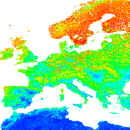
GLDAS-2.1: Global Land Data Assimilation System
NASA Global Land Data Assimilation System Version 2 (GLDAS-2) has three components: GLDAS-2.0, GLDAS-2.1, and GLDAS-2.2. GLDAS-2.0 is forced entirely with the Princeton meteorological forcing input data and provides a temporally consistent series from 1948 through 2014. GLDAS-2.1 is forced with a combination of model … 3-hourly climate cryosphere evaporation forcing geophysical -
GLDAS-2.2: Global Land Data Assimilation System

NASA Global Land Data Assimilation System Version 2 (GLDAS-2) has three components: GLDAS-2.0, GLDAS-2.1, and GLDAS-2.2. GLDAS-2.0 is forced entirely with the Princeton meteorological forcing input data and provides a temporally consistent series from 1948 through 2014. GLDAS-2.1 is forced with a combination of model … 3-hourly climate cryosphere evaporation forcing geophysical -
MERRA-2 M2T1NXLND: Land Surface Diagnostics V5.12.4
M2T1NXLND (or tavg1_2d_lnd_Nx) is an hourly time-averaged data collection in Modern-Era Retrospective analysis for Research and Applications version 2 (MERRA-2). This collection consists of land surface diagnostics, such a baseflow flux, runoff, surface soil wetness, root zone soil wetness, water at surface layer, water at … climate cryosphere evaporation ice merra precipitation -
NLDAS-2: North American Land Data Assimilation System Forcing Fields
Land Data Assimilation System (LDAS) combines multiple sources of observations (such as precipitation gauge data, satellite data, and radar precipitation measurements) to produce estimates of climatological properties at or near the Earth''s surface. This dataset is the primary (default) forcing file (File A) for Phase … climate evaporation forcing geophysical hourly humidity -
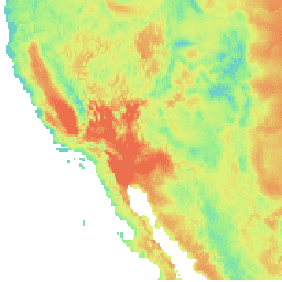
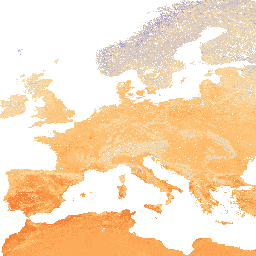
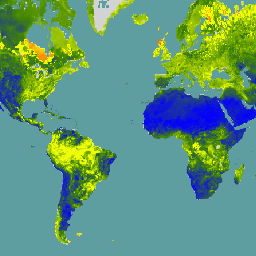
OpenLandMap Clay Content
Clay content in % (kg / kg) at 6 standard depths (0, 10, 30, 60, 100 and 200 cm) at 250 m resolution Based on machine learning predictions from global compilation of soil profiles and samples. Processing steps are described in detail here. Antarctica is … clay envirometrix opengeohub openlandmap soil usda -
OpenLandMap Predicted Hapludalfs Probability
Predicted USDA soil great groups at 250 m (probabilities). Distribution of the USDA soil great groups based on machine learning predictions from global compilation of soil profiles. To learn more about soil great groups please refer to the Illustrated Guide to Soil Taxonomy - NRCS … envirometrix opengeohub openlandmap soil -
OpenLandMap Sand Content
Sand content in % (kg / kg) at 6 standard depths (0, 10, 30, 60, 100 and 200 cm) at 250 m resolution Based on machine learning predictions from global compilation of soil profiles and samples. Processing steps are described in detail here. Antarctica is … envirometrix opengeohub openlandmap sand soil usda -
OpenLandMap Soil Bulk Density
Soil bulk density (fine earth) 10 x kg / m3 at 6 standard depths (0, 10, 30, 60, 100 and 200 cm) at 250 m resolution. Processing steps are described in detail here. Antarctica is not included. To access and visualize maps outside of Earth … density envirometrix opengeohub openlandmap soil -
OpenLandMap Soil Organic Carbon Content
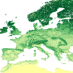
Soil organic carbon content in x 5 g / kg at 6 standard depths (0, 10, 30, 60, 100 and 200 cm) at 250 m resolution Predicted from a global compilation of soil points. Processing steps are described in detail here. Antarctica is not included. … carbon envirometrix opengeohub openlandmap soil -
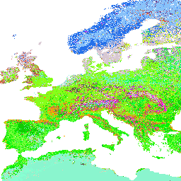
OpenLandMap Soil Texture Class (USDA System)
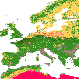
Soil texture classes (USDA system) for 6 soil depths (0, 10, 30, 60, 100 and 200 cm) at 250 m Derived from predicted soil texture fractions using the soiltexture package in R. Processing steps are described in detail here. Antarctica is not included. To access … envirometrix opengeohub openlandmap soil usda -
OpenLandMap Soil Water Content at 33kPa (Field Capacity)
Soil water content (volumetric %) for 33kPa and 1500kPa suctions predicted at 6 standard depths (0, 10, 30, 60, 100 and 200 cm) at 250 m resolution Training points are based on a global compilation of soil profiles: USDA NCSS AfSPDB ISRIC WISE EGRPR SPADE … envirometrix opengeohub openlandmap soil -
OpenLandMap Soil pH in H2O
Soil pH in H2O at 6 standard depths (0, 10, 30, 60, 100 and 200 cm) at 250 m resolution Processing steps are described in detail here. Antarctica is not included. To access and visualize maps outside of Earth Engine, use this page. If you … envirometrix opengeohub openlandmap ph soil -
OpenLandMap USDA Soil Taxonomy Great Groups
Predicted USDA soil great group probabilities at 250m. Distribution of the USDA soil great groups based on machine learning predictions from global compilation of soil profiles. To learn more about soil great groups please refer to the Illustrated Guide to Soil Taxonomy - NRCS - … envirometrix opengeohub openlandmap soil usda -
Reprocessed GLDAS-2.0: Global Land Data Assimilation System

NASA Global Land Data Assimilation System Version 2 (GLDAS-2) has three components: GLDAS-2.0, GLDAS-2.1, and GLDAS-2.2. GLDAS-2.0 is forced entirely with the Princeton meteorological forcing input data and provides a temporally consistent series from 1948 through 2014. GLDAS-2.1 is forced with a combination of model … 3-hourly climate cryosphere evaporation forcing geophysical -
SLGA: Soil and Landscape Grid of Australia (Soil Attributes)
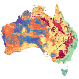
The Soil and Landscape Grid of Australia (SLGA) is a comprehensive dataset of soil attributes across Australia at 3 arc-second resolution (~90m pixels). The surfaces are the outcomes from modelling that describe the spatial distribution of the soil attributes using existing soil data and environmental … australia csiro soil tern -
SOLUS: Soil properties of the conterminous United States at 100-m resolution
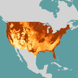
SOLUS (Soil Landscapes of the United States) is a national map product developed by the National Cooperative Soil Survey that is focused on providing a consistent set of spatially continuous soil property maps to support large scope soil investigations and land use decisions. SOLUS maps … soil usda -
SPL3SMP_E.005 SMAP L3 Radiometer Global Daily 9 km Soil Moisture

Data starting from 2023-12-04 are available in the NASA/SMAP/SPL3SMP_E/006 collection. This Level-3 (L3) soil moisture product provides a daily composite of global land surface conditions retrieved by the Soil Moisture Active Passive (SMAP) L-Band radiometer. The daily data here were collected from the descending (local … drought nasa smap soil soil-moisture surface -
SPL3SMP_E.006 SMAP L3 Radiometer Global Daily 9 km Soil Moisture
Data prior from 2023-12-04 are available in the older NASA/SMAP/SPL3SMP_E/005 collection. They will eventually be reprocessed and added to this collection. This Level-3 (L3) soil moisture product provides a daily composite of global land surface conditions retrieved by the Soil Moisture Active Passive (SMAP) L-Band … drought nasa smap soil soil-moisture surface -
SPL4SMGP.008 SMAP L4 Global 3-hourly 9-km Surface and Root Zone Soil Moisture
The SMAP Level-4 (L4) Soil Moisture product includes surface soil moisture (0-5 cm vertical average), root-zone soil moisture (0-100 cm vertical average), and additional research products (not validated), including surface meteorological forcing variables, soil temperature, evapotranspiration, and net radiation. This dataset, formally known as the … drought nasa smap soil soil-moisture surface -
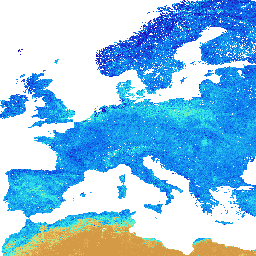
SoilGrids250m 2.0 - Volumetric Water Content
Volumetric Water Content at 10kPa, 33kPa, and 1500kPa suction in 10^-3 cm^3/cm^3 (0.1 v% or 1 mm/m) at 6 standard depths (0-5cm, 5-15cm, 15-30cm, 30-60cm, 60-100cm, 100-200cm). Predictions were derived using a digital soil mapping approach based on Quantile Random Forest, drawing on a global … soil soil-moisture water -
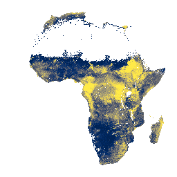
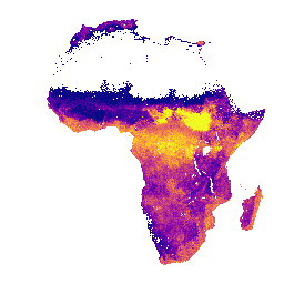
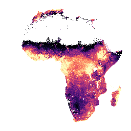
iSDAsoil Bulk Density, <2mm Fraction
Bulk density, <2mm fraction at soil depths of 0-20 cm and 20-50 cm, predicted mean and standard deviation. Pixel values must be back-transformed with x/100. In areas of dense jungle (generally over central Africa), model accuracy is low and therefore artifacts such as banding (striping) … africa isda soil -
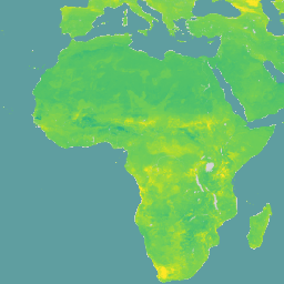
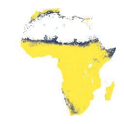
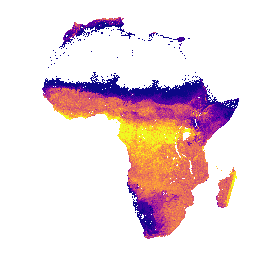
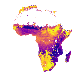
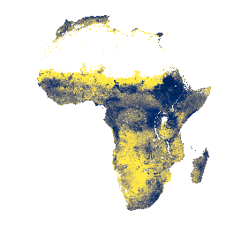
iSDAsoil Clay Content
Clay content at soil depths of 0-20 cm and 20-50 cm,\npredicted mean and standard deviation. In areas of dense jungle (generally over central Africa), model accuracy is low and therefore artifacts such as banding (striping) might be seen. Soil property predictions were made by Innovative … africa clay isda soil -
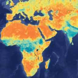
iSDAsoil Depth to Bedrock
Depth to bedrock at 0-200 cm depth, predicted mean and standard deviation. Due to the potential cropland mask that was used for generating the data, many areas of exposed rock (where depth to bedrock would be 0 cm) have been masked out and therefore appear … africa bedrock isda soil -
iSDAsoil Effective Cation Exchange Capacity
Effective Cation Exchange Capacity predicted mean and standard deviation at soil depths of 0-20 cm and 20-50 cm, Pixel values must be back-transformed with exp(x/10)-1. In areas of dense jungle (generally over central Africa), model accuracy is low and therefore artifacts such as banding (striping) … africa aluminium isda soil -
iSDAsoil Extractable Calcium
Extractable calcium at soil depths of 0-20 cm and 20-50 cm, predicted mean and standard deviation. Pixel values must be back-transformed with exp(x/10)-1. In areas of dense jungle (generally over central Africa), model accuracy is low and therefore artifacts such as banding (striping) might be … africa isda soil -
iSDAsoil Extractable Iron
Extractable iron at soil depths of 0-20 cm and 20-50 cm, predicted mean and standard deviation. Pixel values must be back-transformed with exp(x/10)-1. In areas of dense jungle (generally over central Africa), model accuracy is low and therefore artifacts such as banding (striping) might be … africa isda soil -
iSDAsoil Extractable Magnesium
Extractable magnesium at soil depths of 0-20 cm and 20-50 cm, predicted mean and standard deviation. Pixel values must be back-transformed with exp(x/10)-1. In areas of dense jungle (generally over central Africa), model accuracy is low and therefore artifacts such as banding (striping) might be … africa isda soil -
iSDAsoil Extractable Phosphorus
Extractable phosphorus at soil depths of 0-20 cm and 20-50 cm, predicted mean and standard deviation. Pixel values must be back-transformed with exp(x/10)-1. In areas of dense jungle (generally over central Africa), model accuracy is low and therefore artifacts such as banding (striping) might be … africa isda soil -
iSDAsoil Extractable Potassium
Extractable potassium at soil depths of 0-20 cm and 20-50 cm, predicted mean and standard deviation. Pixel values must be back-transformed with exp(x/10)-1. In areas of dense jungle (generally over central Africa), model accuracy is low and therefore artifacts such as banding (striping) might be … africa isda soil -
iSDAsoil Extractable Sulfur
Extractable sulfur at soil depths of 0-20 cm and 20-50 cm, predicted mean and standard deviation. Pixel values must be back-transformed with exp(x/10)-1. In areas of dense jungle (generally over central Africa), model accuracy is low and therefore artifacts such as banding (striping) might be … africa isda soil -
iSDAsoil Extractable Zinc
Extractable zinc at soil depths of 0-20 cm and 20-50 cm, predicted mean and standard deviation. Pixel values must be back-transformed with exp(x/10)-1. In areas of dense jungle (generally over central Africa), model accuracy is low and therefore artifacts such as banding (striping) might be … africa isda soil -
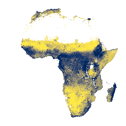
iSDAsoil Fertility Capability Classification
Soil fertility capability classification derived using slope, chemical, and physical soil properties. For more information about this layer, please visit this page. The classes for the 'fcc' band apply to pixel values that must be back-transformed with x modulo 3000. In areas of dense jungle … africa isda soil -
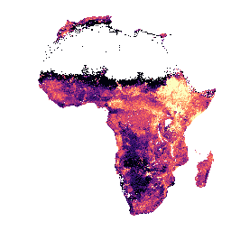
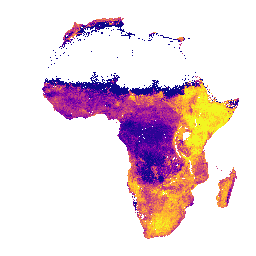
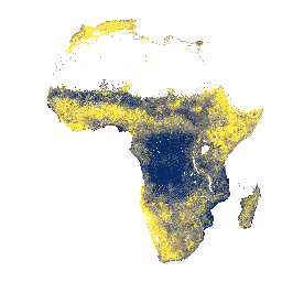
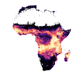
iSDAsoil Organic Carbon
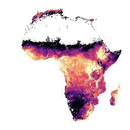
Organic carbon at soil depths of 0-20 cm and 20-50 cm, predicted mean and standard deviation. Pixel values must be back-transformed with exp(x/10)-1. In areas of dense jungle (generally over central Africa), model accuracy is low and therefore artifacts such as banding (striping) might be … africa carbon isda soil -
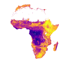
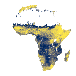
iSDAsoil Sand Content
Sand content at soil depths of 0-20 cm and 20-50 cm,\npredicted mean and standard deviation. In areas of dense jungle (generally over central Africa), model accuracy is low and therefore artifacts such as banding (striping) might be seen. Soil property predictions were made by Innovative … africa isda sand soil -
iSDAsoil Silt Content
Silt content at soil depths of 0-20 cm and 20-50 cm, predicted mean and standard deviation. Pixel values must be back-transformed with exp(x/10)-1. In areas of dense jungle (generally over central Africa), model accuracy is low and therefore artifacts such as banding (striping) might be … africa isda soil -
iSDAsoil Stone Content
Stone content at soil depths of 0-20 cm and 20-50 cm, predicted mean and standard deviation. Pixel values must be back-transformed with exp(x/10)-1. In areas of dense jungle (generally over central Africa), model accuracy is low and therefore artifacts such as banding (striping) might be … africa isda soil -
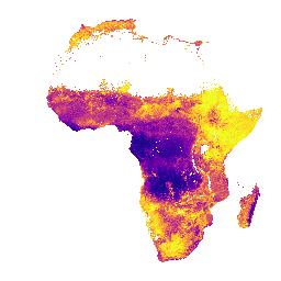
iSDAsoil Total Carbon
Total carbon at soil depths of 0-20 cm and 20-50 cm, predicted mean and standard deviation. Pixel values must be back-transformed with exp(x/10)-1. In areas of dense jungle (generally over central Africa), model accuracy is low and therefore artifacts such as banding (striping) might be … africa aluminium isda soil -
iSDAsoil Total Nitrogen
Total nitrogen at soil depths of 0-20 cm and 20-50 cm, predicted mean and standard deviation. Pixel values must be back-transformed with exp(x/100)-1. In areas of dense jungle (generally over central Africa), model accuracy is low and therefore artifacts such as banding (striping) might be … africa isda nitrogen soil -
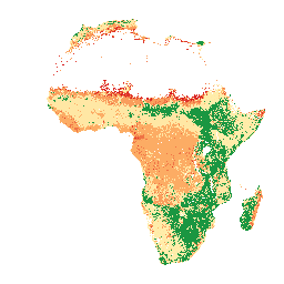
iSDAsoil USDA Texture Class
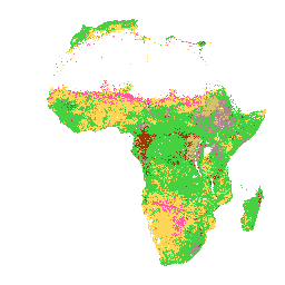
USDA Texture Class at soil depths of 0-20 cm and 20-50 cm. In areas of dense jungle (generally over central Africa), model accuracy is low and therefore artifacts such as banding (striping) might be seen. Soil property predictions were made by Innovative Solutions for Decision … africa aluminium isda soil -
iSDAsoil extractable Aluminium
Extractable aluminium at soil depths of 0-20 cm and 20-50 cm, predicted mean and standard deviation. Pixel values must be back-transformed with exp(x/10)-1. Soil property predictions were made by Innovative Solutions for Decision Agriculture Ltd. (iSDA) at 30 m pixel size using machine learning coupled … africa aluminium isda soil -
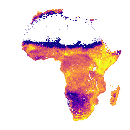
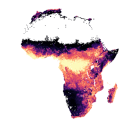
iSDAsoil pH
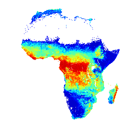
pH at soil depths of 0-20 cm and 20-50 cm, predicted mean and standard deviation. Pixel values must be back-transformed with x/10. In areas of dense jungle (generally over central Africa), model accuracy is low and therefore artifacts such as banding (striping) might be seen. … africa isda ph soil