Page Summary
-
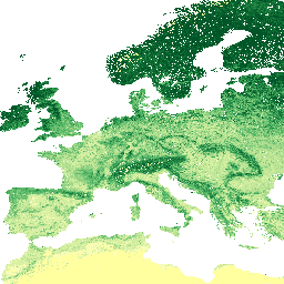
This dataset provides soil organic carbon content at 6 standard depths (0, 10, 30, 60, 100 and 200 cm) at 250 m resolution.
-
The data is available from 1950 to 2018 and was provided by EnvirometriX Ltd.
-
The soil organic carbon content is measured in g/kg, with a scale of 5, and estimated minimum and maximum values of 0 and 120 respectively.
-
The dataset is predicted from a global compilation of soil points and does not include Antarctica.
-
The terms of use for this dataset are CC-BY-SA-4.0.
- Dataset Availability
- 1950-01-01T00:00:00Z–2018-01-01T00:00:00Z
- Dataset Producer
- EnvirometriX Ltd
- Tags
Description
Soil organic carbon content in x 5 g / kg at 6 standard depths (0, 10, 30, 60, 100 and 200 cm) at 250 m resolution
Predicted from a global compilation of soil points. Processing steps are described in detail here. Antarctica is not included.
To access and visualize maps outside of Earth Engine, use this page.
If you discover a bug, artifact or inconsistency in the LandGIS maps or if you have a question please use the following channels:
Bands
Bands
Pixel size: 250 meters (all bands)
| Name | Units | Min | Max | Scale | Pixel Size | Description |
|---|---|---|---|---|---|---|
b0 |
g/kg | 0* | 120* | 5 | 250 meters | Soil organic carbon content at 0 cm depth |
b10 |
g/kg | 0* | 120* | 5 | 250 meters | Soil organic carbon content at 10 cm depth |
b30 |
g/kg | 0* | 120* | 5 | 250 meters | Soil organic carbon content at 30 cm depth |
b60 |
g/kg | 0* | 120* | 5 | 250 meters | Soil organic carbon content at 60 cm depth |
b100 |
g/kg | 0* | 120* | 5 | 250 meters | Soil organic carbon content at 100 cm depth |
b200 |
g/kg | 0* | 120* | 5 | 250 meters | Soil organic carbon content at 200 cm depth |
Terms of Use
Terms of Use
Citations
Tomislav Hengl, & Ichsani Wheeler. (2018). Soil organic carbon content in x 5 g / kg at 6 standard depths (0, 10, 30, 60, 100 and 200 cm) at 250 m resolution (Version v02) [Data set]. Zenodo. 10.5281/zenodo.1475457
DOIs
Explore with Earth Engine
Code Editor (JavaScript)
var dataset = ee.Image('OpenLandMap/SOL/SOL_ORGANIC-CARBON_USDA-6A1C_M/v02');

var visualization = {
  bands: ['b0'],
  min: 0.0,
  max: 120.0,
  palette: [
    'ffffa0','f7fcb9','d9f0a3','addd8e','78c679','41ab5d',
    '238443','005b29','004b29','012b13','00120b',
  ]
};

Map.centerObject(dataset);

Map.addLayer(dataset, visualization, 'Soil organic carbon content in x 5 g / kg');