-
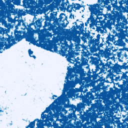
코코아 확률 모델 2025a

이 이미지 모음은 기본 영역이 상품으로 점유될 픽셀당 확률을 추정하여 제공합니다. 확률 추정치는 10m 해상도로 제공되며 머신러닝 모델에 의해 생성되었습니다. 자세한 내용은 산림 데이터 파트너십에 관한 기술 문서를 참고하세요. 농업 생물 다양성 코코아 보존 작물 eudr -
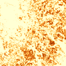
코코아 확률 모델 2025b
이 이미지 모음은 기본 영역이 상품으로 점유될 픽셀당 확률을 추정하여 제공합니다. 확률 추정치는 10m 해상도로 제공되며 머신러닝 모델에 의해 생성되었습니다. 자세한 내용은 산림 데이터 파트너십에 관한 기술 문서를 참고하세요. agriculture alphaearth-derived biodiversity cocoa conservation crop -
커피 확률 모델 2025a

이 이미지 모음은 기본 영역이 상품으로 점유될 픽셀당 확률을 추정하여 제공합니다. 확률 추정치는 10m 해상도로 제공되며 머신러닝 모델에 의해 생성되었습니다. 자세한 내용은 산림 데이터 파트너십에 관한 기술 문서를 참고하세요. 농업 생물 다양성 커피 보존 작물 eudr -
커피 확률 모델 2025b
이 이미지 모음은 기본 영역이 상품으로 점유될 픽셀당 확률을 추정하여 제공합니다. 확률 추정치는 10m 해상도로 제공되며 머신러닝 모델에 의해 생성되었습니다. 자세한 내용은 산림 데이터 파트너십에 관한 기술 문서를 참고하세요. agriculture alphaearth-derived biodiversity coffee conservation crop -
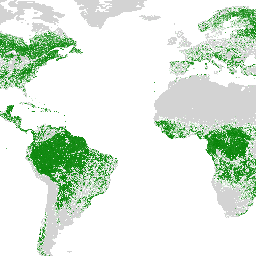
EC JRC 전 세계 산림 피복 지도 2020, V3
산림 피복의 전 세계 지도는 2020년 기준 산림 존재 여부를 10m 공간 해상도로 명시한 공간 데이터입니다. 2020년은 유럽연합의 '…에 제공되는 제품의 안전성 및 성능에 관한 규정'의 기준일에 해당합니다. eudr forest forest-biomass jrc -
EC JRC 전 세계 산림 유형 지도 2020, V1
산림 유형의 전 세계 지도는 2020년 기준 원시림, 자연 재생림, 식재림 (조림지 포함)의 분포 현황을 10m 공간 해상도로 명시한 공간 데이터입니다. 이러한 산림 유형을 매핑하기 위한 기본 레이어는 산림 피복 범위입니다. eudr forest forest-biomass jrc landcover primary-forest -
Forest Persistence v0

이 이미지는 2020년에 픽셀 영역이 방해받지 않은 숲으로 구성되어 있는지 여부를 나타내는 픽셀별 점수([0, 1])를 제공합니다. 이러한 점수는 30미터 해상도로 제공되며, 여러 산림을 결합하는 증거 수렴 접근 방식을 통해 생성되었습니다. 생물 다양성 보존 삼림 파괴 eudr 산림 바이오매스 forestdatapartnership -
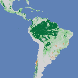
산림 유형 (ForTy) 2020 v1.0
Forest Typology (ForTy) v1 데이터 세트는 2020년 기준 위도 65°S~84°N의 모든 육지 지역을 포함하는 10m 해상도의 전역 클래스별 확률 지도입니다. 6개 클래스 유형은 FAO 및 EU 산림 파괴 규정 (EUDR) 정의와 일치합니다. 클래스 1 … alphaearth-derived biodiversity climate conservation deforestation eudr -
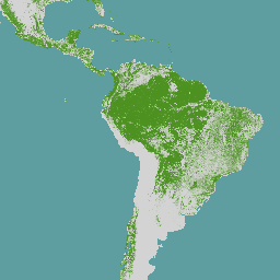
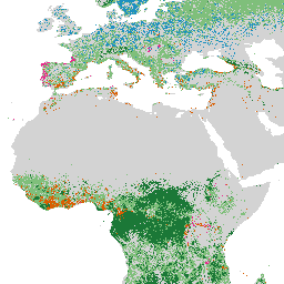
2020년 세계의 자연림
Natural Forests of the World 2020은 2020년 기준 10미터 해상도의 전 세계 천연림 분포 확률 지도를 제공합니다. 이 레이어는 유럽 연합의 산림파괴 규정 (EUDR)과 같은 이니셔티브 및 산림 보존과 모니터링을 위한 기타 노력을 지원하기 위해 개발되었습니다. 지도 … 생물 다양성 기후 보존 삼림 파괴 eudr 산림 -
Palm 확률 모델 2025a

이 이미지 모음은 기본 영역이 상품으로 점유될 픽셀당 확률을 추정하여 제공합니다. 확률 추정치는 10m 해상도로 제공되며 머신러닝 모델에 의해 생성되었습니다. 자세한 내용은 산림 데이터 파트너십에 관한 기술 문서를 참고하세요. agriculture biodiversity conservation crop eudr forestdatapartnership -
Palm 확률 모델 2025b
이 이미지 모음은 기본 영역이 상품으로 점유될 픽셀당 확률을 추정하여 제공합니다. 확률 추정치는 10m 해상도로 제공되며 머신러닝 모델에 의해 생성되었습니다. 자세한 내용은 산림 데이터 파트너십에 관한 기술 문서를 참고하세요. agriculture alphaearth-derived biodiversity conservation crop eudr -
고무 확률 모델 2025b
이 이미지 모음은 기본 영역이 상품으로 점유될 픽셀당 확률을 추정하여 제공합니다. 확률 추정치는 10m 해상도로 제공되며 머신러닝 모델에 의해 생성되었습니다. 자세한 내용은 산림 데이터 파트너십에 관한 기술 문서를 참고하세요. agriculture alphaearth-derived biodiversity conservation crop eudr -
고무나무 확률 모델 2025a

이 이미지 모음은 기본 영역이 상품으로 점유될 픽셀당 확률을 추정하여 제공합니다. 확률 추정치는 10m 해상도로 제공되며 머신러닝 모델에 의해 생성되었습니다. 자세한 내용은 산림 데이터 파트너십에 관한 기술 문서를 참고하세요. agriculture biodiversity conservation crop eudr forestdatapartnership