NOTA del WRI: El WRI decidió dejar de actualizar las alertas de FORMA. El objetivo era simplificar la experiencia del usuario de Global Forest Watch y reducir la redundancia.
Descubrimos que Terra-i y GLAD se usaban con mayor frecuencia.
Además, al usar GLAD como estándar, se descubrió que Terra-i superó a FORMA a nivel mundial.
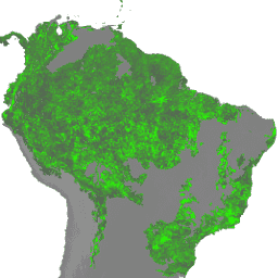
Las alertas de FORMA se detectan con una combinación de dos productos de MODIS: el NDVI (índice de vegetación de diferencia normalizada) y FIRMS (Fires Information for Resource Management System). Las actualizaciones del NDVI se procesan cada 16 días, mientras que las de incendios se procesan a diario. Los modelos se desarrollan de forma individual para cada ecogrupo con el objetivo de relacionar las dos entradas con el área de deforestación, y se usan los datos anuales de pérdida de cobertura arbórea de Hansen para entrenar el modelo. El umbral mínimo para calificar como alerta es el 25% de los píxeles despejados, aunque los umbrales varían según el grupo ecológico para minimizar los falsos positivos.
Aquí tienes un ejemplo de secuencia de comandos para una introducción rápida a los conjuntos de datos de FORMA.
Las imágenes de esta ImageCollection contienen las "estadísticas t rectificadas invertidas" que se usan para calcular el NTT, el índice de color de la vegetación derivado del NDVI de MODIS que FORMA usa para medir el pardeamiento. Si se usa un reductor de suma en varios períodos de esta ImageCollection, se produce una imagen de "NTT".
Las imágenes se desglosan por "ecogroup".
Bandas
Tamaño del píxel 250 metros
Bandas
Nombre
Mín.
Máx.
Tamaño de los píxeles
Descripción
tstat_r
0*
25.41*
metros
Estadísticas t invertidas y rectificadas, es decir, (máx.(0, -t_stat)).
* Valor mínimo o máximo estimado
Propiedades de imágenes
Propiedades de la imagen
Nombre
Tipo
Descripción
año
INT
Año de los datos más recientes incluidos en el conjunto de datos
quincenal
INT
El período quincenal (cada 16 días) del año
ecogroup_id
STRING
ID del grupo ecológico asociado
Condiciones de Uso
Condiciones de Uso
Los conjuntos de datos de FORMA están disponibles sin restricciones de uso ni distribución. El WRI solicita que el usuario proporcione la atribución adecuada y que identifique al WRI y a GFW, cuando corresponda, como la fuente de los datos.
NOTA del WRI: El WRI decidió dejar de actualizar las alertas de FORMA. El objetivo era simplificar la experiencia del usuario de Global Forest Watch y reducir la redundancia. Descubrimos que Terra-i y GLAD se usaban con mayor frecuencia. Además, al usar GLAD como estándar, se descubrió que Terra-i superó a FORMA a nivel mundial. Se detectan alertas de FORMA…
[[["Fácil de comprender","easyToUnderstand","thumb-up"],["Resolvió mi problema","solvedMyProblem","thumb-up"],["Otro","otherUp","thumb-up"]],[["Falta la información que necesito","missingTheInformationINeed","thumb-down"],["Muy complicado o demasiados pasos","tooComplicatedTooManySteps","thumb-down"],["Desactualizado","outOfDate","thumb-down"],["Problema de traducción","translationIssue","thumb-down"],["Problema con las muestras o los códigos","samplesCodeIssue","thumb-down"],["Otro","otherDown","thumb-down"]],[],[[["\u003cp\u003eThe FORMA dataset provides MODIS-based vegetation change alerts, specifically "reversed rectified t-statistics" used to measure browning, with a resolution of 250 meters.\u003c/p\u003e\n"],["\u003cp\u003eWRI has discontinued updating FORMA alerts, recommending Terra-i and GLAD as preferred alternatives due to their performance and user experience.\u003c/p\u003e\n"],["\u003cp\u003eFORMA alerts were generated using NDVI and FIRMS data, trained with Hansen tree cover loss data, and triggered when 25% or more of a pixel was cleared.\u003c/p\u003e\n"],["\u003cp\u003eThe dataset is organized by ecogroups and includes bi-weekly periods for the years 2012 to 2019.\u003c/p\u003e\n"],["\u003cp\u003eThe FORMA datasets are available for use without restriction, but attribution to WRI and GFW is requested.\u003c/p\u003e\n"]]],["The WRI/GFW/FORMA vegetation t-statistics dataset, provided by the World Resources Institute/Global Forest Watch, spans from 2012 to 2019. It uses MODIS-derived NDVI and FIRMS data to detect forest clearing alerts, updating NDVI every 16 days and fire data daily. Alerts are generated when at least 25% of a pixel is cleared. The dataset, which is no longer updated, provides reversed rectified t-statistics used to measure vegetation browning and is broken down by ecogroup with 250-meter pixel size.\n"],null,["# FORMA Vegetation T-Statistics\n\nDataset Availability\n: 2012-01-01T00:00:00Z--2019-04-23T00:00:00Z\n\nDataset Provider\n:\n\n\n [World Resources Institute / Global Forest Watch](https://www.globalforestwatch.org/)\n\nTags\n:\n[daily](/earth-engine/datasets/tags/daily) [deforestation](/earth-engine/datasets/tags/deforestation) [forest](/earth-engine/datasets/tags/forest) [forest-biomass](/earth-engine/datasets/tags/forest-biomass) [forma](/earth-engine/datasets/tags/forma) [gfw](/earth-engine/datasets/tags/gfw) [modis](/earth-engine/datasets/tags/modis) [monitoring](/earth-engine/datasets/tags/monitoring) [wri](/earth-engine/datasets/tags/wri) \n\n#### Description\n\n**NOTE from WRI** : WRI decided to stop updating FORMA alerts. The goal was\nto simplify the [Global Forest Watch](https://www.globalforestwatch.org)\nuser experience and reduce redundancy.\nWe found that [Terra-i](http://www.terra-i.org/terra-i.html) and\n[GLAD](https://glad-forest-alert.appspot.com/) were more frequently used.\nMoreover, using GLAD as a standard, found that Terra-i outperformed\nFORMA globally.\n\nFORMA alerts are detected using a combination of two MODIS\nproducts: NDVI (Normalized Difference Vegetation Index) and FIRMS\n(Fires Information for Resource Management System). NDVI updates are\nprocessed every 16 days, while fire updates are processed daily. Models\nare developed individually for each ecogroup to relate the two inputs to\nthe area of clearing, using the Hansen annual tree cover loss data to train\nthe model. The minimum threshold to qualify as an alert is 25% of the pixel\ncleared, though thresholds vary by ecogroup to minimize false positives.\nHere is an [example script](https://code.earthengine.google.com/f29b1e4360f3fc36847bd789ceeb20f6)\nfor a quick introduction to the FORMA datasets.\n\nThe images in this ImageCollection contain the \"reversed rectified\nt-statistics\" used in calculating NTT, the vegetation color index derived\nfrom MODIS NDVI that FORMA uses to measure browning. Using a sum reducer on\nover various date ranges in this ImageCollection produces an \"NTT\" image.\n\nThe images are broken by \"ecogroup\".\n\n### Bands\n\n\n**Pixel Size**\n\n250 meters\n\n**Bands**\n\n| Name | Min | Max | Pixel Size | Description |\n|-----------|-----|---------|------------|--------------------------------------------------------|\n| `tstat_r` | 0\\* | 25.41\\* | meters | Reversed rectified, ie (max(0,-t_stat)), t-statistics. |\n\n\\* estimated min or max value\n\n### Image Properties\n\n**Image Properties**\n\n| Name | Type | Description |\n|-------------|--------|------------------------------------------------------|\n| year | INT | Year of the most recent data included in the dataset |\n| biweekly | INT | The biweekly (every 16 days) period of the year |\n| ecogroup_id | STRING | ID of associated ecogroup |\n\n### Terms of Use\n\n**Terms of Use**\n\nThe FORMA datasets are available without restriction\non use or distribution. WRI does request that the\nuser give proper attribution and identify WRI and GFW, where applicable,\nas the source of the data.\n\n### Explore with Earth Engine\n\n| **Important:** Earth Engine is a platform for petabyte-scale scientific analysis and visualization of geospatial datasets, both for public benefit and for business and government users. Earth Engine is free to use for research, education, and nonprofit use. To get started, please [register for Earth Engine access.](https://console.cloud.google.com/earth-engine)\n\n### Code Editor (JavaScript)\n\n```javascript\nvar dataset = ee.ImageCollection('WRI/GFW/FORMA/vegetation_tstats')\n .filter(ee.Filter.date('2018-07-01', '2018-07-15'));\nvar tstat = dataset.select('tstat_r');\nvar visParams = {\n min: 0,\n max: 1,\n};\nMap.setCenter(26, -8, 3);\nMap.addLayer(tstat, visParams, 'Reversed rectified t-statistics');\n```\n[Open in Code Editor](https://code.earthengine.google.com/?scriptPath=Examples:Datasets/WRI/WRI_GFW_FORMA_vegetation_tstats) \n[FORMA Vegetation T-Statistics](/earth-engine/datasets/catalog/WRI_GFW_FORMA_vegetation_tstats) \nNOTE from WRI: WRI decided to stop updating FORMA alerts. The goal was to simplify the Global Forest Watch user experience and reduce redundancy. We found that Terra-i and GLAD were more frequently used. Moreover, using GLAD as a standard, found that Terra-i outperformed FORMA globally. FORMA alerts are detected ... \nWRI/GFW/FORMA/vegetation_tstats, daily,deforestation,forest,forest-biomass,forma,gfw,modis,monitoring,wri \n2012-01-01T00:00:00Z/2019-04-23T00:00:00Z \n-50 -120 40 180 \nGoogle Earth Engine \nhttps://developers.google.com/earth-engine/datasets\n\n- [](https://doi.org/https://www.globalforestwatch.org/)\n- [](https://doi.org/https://developers.google.com/earth-engine/datasets/catalog/WRI_GFW_FORMA_vegetation_tstats)"]]