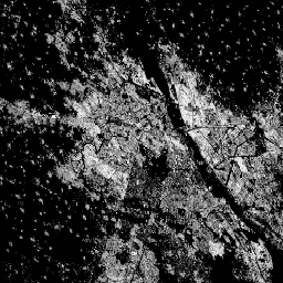
This raster dataset depicts the distribution of built-up surfaces,
expressed in square metres per 100 m grid cell.
The dataset measures:
a) the total built-up surface, and b) the built-up surface allocated to grid
cells of predominant non-residential (NRES) use. Data are
spatially-temporally interpolated or extrapolated from 1975 to 2030 in 5
year intervals.
The Global Human Settlement Layer (GHSL) project is supported by the
European Commission, Joint Research Centre, and Directorate-General for
Regional and Urban Policy.
Bands
Pixel Size 100 meters
Bands
Name
Units
Pixel Size
Description
built_surface
m^2
meters
Built-up surface per grid cell
built_surface_nres
m^2
meters
Non-residential built-up surface per grid cell
Terms of Use
Terms of Use
The GHSL has been produced by the European Commission Joint Research Centre
as open and free data. Reuse is authorised, provided the source is
acknowledged. For more information, please read the use conditions (European
Commission Reuse and Copyright Notice).
Methodology : Pesaresi, Martino, Marcello Schiavina, Panagiotis Politis,
Sergio Freire, Katarzyna Krasnodebska,
Johannes H. Uhl, Alessandra Carioli, et al. (2024). Advances on the
Global Human Settlement Layer by Joint Assessment of Earth Observation
and Population Survey Data. International Journal of Digital Earth 17(1).
doi:10.1080/17538947.2024.2390454.
This raster dataset depicts the distribution of built-up surfaces, expressed in square metres per 100 m grid cell. The dataset measures: a) the total built-up surface, and b) the built-up surface allocated to grid cells of predominant non-residential (NRES) use. Data are spatially-temporally interpolated or extrapolated from 1975 to 2030 …
[[["Easy to understand","easyToUnderstand","thumb-up"],["Solved my problem","solvedMyProblem","thumb-up"],["Other","otherUp","thumb-up"]],[["Missing the information I need","missingTheInformationINeed","thumb-down"],["Too complicated / too many steps","tooComplicatedTooManySteps","thumb-down"],["Out of date","outOfDate","thumb-down"],["Samples / code issue","samplesCodeIssue","thumb-down"],["Other","otherDown","thumb-down"]],[],[[["\u003cp\u003eThe Global Human Settlement Layer (GHSL) dataset provides data on built-up surfaces globally, including residential and non-residential areas, at a 100-meter resolution.\u003c/p\u003e\n"],["\u003cp\u003eIt offers temporal coverage from 1975 to 2030 in 5-year intervals, with data spatially-temporally interpolated or extrapolated.\u003c/p\u003e\n"],["\u003cp\u003eDeveloped by the European Commission Joint Research Centre, the dataset is freely available for reuse with proper attribution.\u003c/p\u003e\n"],["\u003cp\u003eThe GHSL dataset is derived from Sentinel-2 and Landsat imagery and provides insights into global urbanization trends.\u003c/p\u003e\n"],["\u003cp\u003eBuilt-up surface is measured in square meters per grid cell and includes both total and non-residential built-up areas.\u003c/p\u003e\n"]]],["The dataset, provided by EC JRC, spans 1975-2030, presenting built-up surface distribution in square meters per 100m grid cell. It quantifies total built-up area and non-residential (NRES) built-up area, extrapolated every five years. The data, available through Earth Engine, includes `built_surface` and `built_surface_nres` bands at 100-meter resolution. It is free to use, and reuse is authorized, provided the source is acknowledged. This information can be explored in the Code Editor.\n"],null,["Dataset Availability\n: 1975-01-01T00:00:00Z--2030-12-31T00:00:00Z\n\nDataset Provider\n:\n\n\n [EC JRC](https://ghsl.jrc.ec.europa.eu/ghs_buS2023.php)\n\nTags\n:\n[built](/earth-engine/datasets/tags/built) [built-environment](/earth-engine/datasets/tags/built-environment) [builtup](/earth-engine/datasets/tags/builtup) [copernicus](/earth-engine/datasets/tags/copernicus) [ghsl](/earth-engine/datasets/tags/ghsl) [jrc](/earth-engine/datasets/tags/jrc) [landcover](/earth-engine/datasets/tags/landcover) [landsat-derived](/earth-engine/datasets/tags/landsat-derived) [population](/earth-engine/datasets/tags/population) [sdg](/earth-engine/datasets/tags/sdg) [sentinel2-derived](/earth-engine/datasets/tags/sentinel2-derived) [settlement](/earth-engine/datasets/tags/settlement) [urban](/earth-engine/datasets/tags/urban) \n\nDescription \nThis raster dataset depicts the distribution of built-up surfaces,\nexpressed in square metres per 100 m grid cell.\nThe dataset measures:\na) the total built-up surface, and b) the built-up surface allocated to grid\ncells of predominant non-residential (NRES) use. Data are\nspatially-temporally interpolated or extrapolated from 1975 to 2030 in 5\nyear intervals.\n\nThe complete information about the GHSL main products can be\nfound in the [GHSL Data Package 2023 report](https://ghsl.jrc.ec.europa.eu/documents/GHSL_Data_Package_2023.pdf?t=1683540422)\n\nThe Global Human Settlement Layer (GHSL) project is supported by the\nEuropean Commission, Joint Research Centre, and Directorate-General for\nRegional and Urban Policy.\n\nBands\n\n\n**Pixel Size**\n\n100 meters\n\n**Bands**\n\n| Name | Units | Description |\n|----------------------|-------|------------------------------------------------|\n| `built_surface` | m\\^2 | Built-up surface per grid cell |\n| `built_surface_nres` | m\\^2 | Non-residential built-up surface per grid cell |\n\nTerms of Use\n\n**Terms of Use**\n\nThe GHSL has been produced by the European Commission Joint Research Centre\nas open and free data. Reuse is authorised, provided the source is\nacknowledged. For more information, please read the use conditions ([European\nCommission Reuse and Copyright Notice](https://ec.europa.eu/info/legal-notice_en)).\n\nCitations \nCitations:\n\n- Dataset : Pesaresi, Martino; Politis, Panagiotis (2023): GHS-BUILT-S\n R2023A - GHS built-up surface grid, derived from Sentinel2 composite and\n Landsat, multitemporal (1975-2030). European Commission, Joint Research\n Centre (JRC).\n [PID: http://data.europa.eu/89h/9f06f36f-4b11-47ec-abb0-4f8b7b1d72ea](http://data.europa.eu/89h/9f06f36f-4b11-47ec-abb0-4f8b7b1d72ea)\n [doi:10.2905/9F06F36F-4B11-47EC-ABB0-4F8B7B1D72EA](https://doi.org/10.2905/9F06F36F-4B11-47EC-ABB0-4F8B7B1D72EA)\n- Methodology : Pesaresi, Martino, Marcello Schiavina, Panagiotis Politis,\n Sergio Freire, Katarzyna Krasnodebska,\n Johannes H. Uhl, Alessandra Carioli, et al. (2024). Advances on the\n Global Human Settlement Layer by Joint Assessment of Earth Observation\n and Population Survey Data. International Journal of Digital Earth 17(1).\n [doi:10.1080/17538947.2024.2390454](https://doi.org/10.1080/17538947.2024.2390454).\n\nDOIs\n\n- \u003chttps://doi.org/10.1080/17538947.2024.2390454\u003e\n- \u003chttps://doi.org/10.2905/9F06F36F-4B11-47EC-ABB0-4F8B7B1D72EA\u003e\n\nExplore with Earth Engine **Important:** Earth Engine is a platform for petabyte-scale scientific analysis and visualization of geospatial datasets, both for public benefit and for business and government users. Earth Engine is free to use for research, education, and nonprofit use. To get started, please [register for Earth Engine access.](https://console.cloud.google.com/earth-engine)\n\nCode Editor (JavaScript) \n\n```javascript\nvar image_1975 = ee.Image('JRC/GHSL/P2023A/GHS_BUILT_S/1975');\nvar built_1975 = image_1975.select('built_surface');\nvar image_2020 = ee.Image('JRC/GHSL/P2023A/GHS_BUILT_S/2020');\nvar built_2020 = image_2020.select('built_surface');\nvar visParams = {min: 0.0, max: 8000.0, palette: ['000000', 'FFFFFF']};\n\nMap.setCenter(77.156, 28.6532, 10);\nMap.addLayer(built_1975, visParams, 'Built-up surface [m2], 1975');\nMap.addLayer(built_2020, visParams, 'Built-up surface [m2], 2020');\n```\n[Open in Code Editor](https://code.earthengine.google.com/?scriptPath=Examples:Datasets/JRC/JRC_GHSL_P2023A_GHS_BUILT_S) \n[GHSL: Global built-up surface 1975-2030 (P2023A)](/earth-engine/datasets/catalog/JRC_GHSL_P2023A_GHS_BUILT_S) \nThis raster dataset depicts the distribution of built-up surfaces, expressed in square metres per 100 m grid cell. The dataset measures: a) the total built-up surface, and b) the built-up surface allocated to grid cells of predominant non-residential (NRES) use. Data are spatially-temporally interpolated or extrapolated from 1975 to 2030 ... \nJRC/GHSL/P2023A/GHS_BUILT_S, built,built-environment,builtup,copernicus,ghsl,jrc,landcover,landsat-derived,population,sdg,sentinel2-derived,settlement,urban \n1975-01-01T00:00:00Z/2030-12-31T00:00:00Z \n-90 -180 90 180 \nGoogle Earth Engine \nhttps://developers.google.com/earth-engine/datasets\n\n- [https://doi.org/10.2905/9F06F36F-4B11-47EC-ABB0-4F8B7B1D72EA](https://doi.org/https://ghsl.jrc.ec.europa.eu/ghs_buS2023.php)\n- [https://doi.org/10.2905/9F06F36F-4B11-47EC-ABB0-4F8B7B1D72EA](https://doi.org/https://developers.google.com/earth-engine/datasets/catalog/JRC_GHSL_P2023A_GHS_BUILT_S)"]]