Page Summary
-
The GHSL: Global building height 2018 (P2023A) dataset shows global building heights at 100m resolution for 2018, derived from ALOS and NASA SRTM data.
-
The GHSL: Global building volume 1975-2030 (P2023A) dataset provides global building volume in cubic meters per 100m grid cell, including total and non-residential volumes.
-
The GHSL: Global built-up surface 10m (P2023A) dataset maps built-up surfaces in square meters per 10m grid cell for 2018 using S2 data, covering total and allocated built-up surfaces.
-
The GHSL: Global built-up surface 1975-2030 (P2023A) dataset presents built-up surface distribution in square meters per 100m grid cell, measuring total and non-residential built-up areas.
-
GHSL: Global building height 2018 (P2023A)
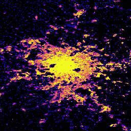
This spatial raster dataset depicts the global distribution of building heights at a resolution of 100 m, referred to the year 2018. The input data used to predict building heights are the ALOS Global Digital Surface Model (30 m), the NASA Shuttle Radar Topographic Mission … alos building built built-environment builtup copernicus -
GHSL: Global building volume 1975-2030 (P2023A)
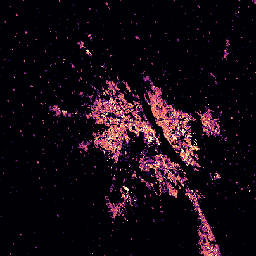
This raster dataset depicts the global distribution of building volume, expressed in cubic metres per 100 m grid cell. The dataset measures the total building volume and the building volume allocated to grid cells of predominant non-residential (NRES) use. Estimates are based on the built-up … alos building built-environment copernicus dem ghsl -
GHSL: Global built-up surface 10m (P2023A)
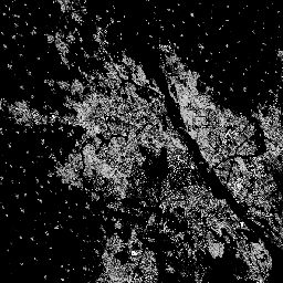
This raster dataset depicts the distribution of built-up surfaces, expressed in square metres per 10 m grid cell, for 2018 as observed from the S2 image data. The datasets measure: a) the total built-up surface, and b) the built-up surface allocated to grid cells of … built built-environment builtup copernicus ghsl jrc -
GHSL: Global built-up surface 1975-2030 (P2023A)
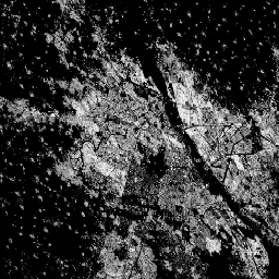
This raster dataset depicts the distribution of built-up surfaces, expressed in square metres per 100 m grid cell. The dataset measures: a) the total built-up surface, and b) the built-up surface allocated to grid cells of predominant non-residential (NRES) use. Data are spatially-temporally interpolated or … built built-environment builtup copernicus ghsl jrc