
Users can control the zoom, tilt, position, and rotation of the camera using gestures on the map. You can also configure the camera programmatically.
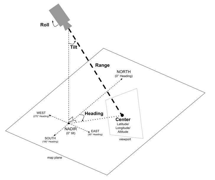
The Camera Position
The map view is modeled as a camera looking at a specific point in space. The position and orientation of the camera are defined by latitude/longitude/altitude coordinates (defined as the "center", where the camera is pointing), heading, tilt, range, and roll.
Center (latitude, longitude, altitude)
The center defines the specific point in 3D space that the camera is
observing. This is specified using the
LatLngAltitude
class, which combines values for latitude, longitude, and altitude. This lets
you position the camera's focal point in three dimensions.
The latitude can be between -90 and 90 degrees, inclusive. Longitude
ranges between -180 and 180 degrees, inclusive. Altitude is specified in meters,
and how the altitude is interpreted is determined by the camera's
altitudeMode
(AltitudeMode.ABSOLUTE
by default,
AltitudeMode.RELATIVE_TO_GROUND,
or
AltitudeMode.RELATIVE_TO_MESH).
Heading
The heading specifies the compass direction of the map, measured in degrees clockwise from true North. North corresponds to 0 degrees, East to 90 degrees, South to 180 degrees, and West to 270 degrees.
Tilt
The tilt specifies the angle of the camera with respect to the vertical axis, measured in degrees. A tilt of 0 degrees means the camera is pointing straight down towards the Earth ( nadir). A tilt of 90 degrees means the camera is pointed horizontally in the direction specified by the heading.
Range
The range defines the distance in meters between the camera's own position and the center of the map. The range can vary from zero meters (very close up) up to sixty-three million meters, allowing for views from very close up all the way to a truly global perspective. This effectively controls how "zoomed in" or "zoomed out" the map appears.
Roll
The roll sets the angle of the camera with respect to the horizon, measured in degrees. This parameter can be used to create effects like banking during flight simulations or even a full barrel roll, rotating the camera around its viewing axis.
Controlling the camera
The following code sample demonstrates how to control theCamera
programmatically by calling the
setCamera
method on
GoogleMap3D.
To use this code sample, follow the instructions in
Setup and Add a 3D map to your
app to set up your
Android Studio project with a basic 3D map. Then, add the following code to the
MainActivity.kt file:
// Add imports
import com.google.android.gms.maps3d.model.Map3DMode
import com.google.android.gms.maps3d.model.camera
import com.google.android.gms.maps3d.model.latLngAltitude

// Add to the onMap3DViewReady method, after the googleMap3D object has been initialized
googleMap3D.setMapMode(Map3DMode.HYBRID)
googleMap3D.setCamera(
    camera {
        center = latLngAltitude {
            latitude = 38.743502
            longitude = -109.499374
            altitude = 1467.0
        }
        heading = 350.0
        tilt = 58.1
        range = 138.2
        roll = 0.0
    }
)
UI controls
In addition to standard gestures, the Maps 3D SDK for Android also provides UI controls for manipulating the position of the camera.
- The Zoom control displays "+" and "-" buttons for changing the zoom level of the map.
- The Move control displays "←", "→", "↑", and "↓" buttons for changing the center of the map.
- The Rotate controls displays "↺" and "↻" to change the camera's heading.
- The Tilt control displays "^" and "⌄" to change the camera's tilt.
- The Compass control indicates the direction of compass north, and allows for resetting the camera to a northerly heading.
The following code sample shows how to change the visibility of the UI controls:
```kotlin // Add imports import com.google.android.gms.maps3d.UiControlSettings import com.google.android.gms.maps3d.model.CompassControl import com.google.android.gms.maps3d.model.TiltControl import com.google.android.gms.maps3d.model.ZoomControl</p> <p>...</p> <p>val uiControlSettings = googleMap3D.getUiControlSettings()</p> <p>// Show UI controls on the trailing edge of the map uiControlSettings?.setUiControlsPlacement( listOf(CompassControl(), ZoomControl(), TiltControl()), UiControlSettings.ControlPlacement.TRAILING )</p> <p>// Hide UI controls on the trailing edge of the map uiControlSettings?.setUiControlsPlacement( emptyList(), UiControlSettings.ControlPlacement.TRAILING )