Page Summary
-
Dynamic World V1 provides 10m near-real-time Land Use/Land Cover data with nine class probabilities and labels from 2015-06-27 to present.
-
USGS Landsat 7 Collection 2 Tier 1 and Real-Time data offers scaled, calibrated at-sensor radiance values for scenes suitable for time-series analysis.
-
USGS Landsat 8 Collection 2 Tier 1 and Real-Time data also provides scaled, calibrated at-sensor radiance values for scenes considered suitable for time-series processing analysis.
-
Dynamic World V1
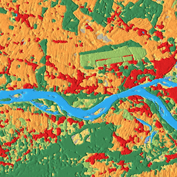
Dynamic World is a 10m near-real-time (NRT) Land Use/Land Cover (LULC) dataset that includes class probabilities and label information for nine classes. Dynamic World predictions are available for the Sentinel-2 L1C collection from 2015-06-27 to present. The revisit frequency of Sentinel-2 is between 2-5 days … global google landcover landuse landuse-landcover nrt -
USGS Landsat 7 Collection 2 Tier 1 and Real-Time data Raw Scenes

Landsat 7 Collection 2 Tier 1 and Real-Time data DN values, representing scaled, calibrated at-sensor radiance. Landsat scenes with the highest available data quality are placed into Tier 1 and are considered suitable for time-series processing analysis. Tier 1 includes Level-1 Precision Terrain (L1TP) processed … c2 etm global l7 landsat le7 -
USGS Landsat 8 Collection 2 Tier 1 and Real-Time data Raw Scenes
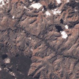
Landsat 8 Collection 2 Tier 1 and Real-Time data DN values, representing scaled, calibrated at-sensor radiance. Landsat scenes with the highest available data quality are placed into Tier 1 and are considered suitable for time-series processing analysis. Tier 1 includes Level-1 Precision Terrain (L1TP) processed … c2 global l8 landsat lc8 nrt