Datasets tagged metdata in Earth Engine
Mit Sammlungen den Überblick behalten
Sie können Inhalte basierend auf Ihren Einstellungen speichern und kategorisieren.
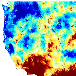
Dieses Dataset enthält Dürreindizes, die aus dem GRIDMET-Dataset (Gridded Surface Meteorological) mit einer täglichen Auflösung von 4 km abgeleitet wurden. Die bereitgestellten Dürreindizes umfassen den standardisierten Niederschlagsindex (SPI), den Index für die Verdunstungsdürre (EDDI), den standardisierten Index für die Gesamtverdunstung von Niederschlag (SPEI), den Palmer-Dürre-Index (PDSI) und Palmer …
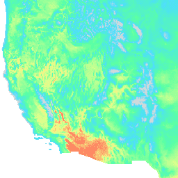
Das Gridded Surface Meteorological-Dataset bietet tägliche Oberflächenfelder mit hoher räumlicher Auflösung (~4 km) für Temperatur, Niederschlag, Wind, Luftfeuchtigkeit und Strahlung für die angrenzenden Vereinigten Staaten ab 1979. In diesem Dataset werden die räumlichen Daten mit hoher Auflösung von PRISM mit den Daten mit hoher zeitlicher Auflösung von … kombiniert.
[[["Leicht verständlich","easyToUnderstand","thumb-up"],["Mein Problem wurde gelöst","solvedMyProblem","thumb-up"],["Sonstiges","otherUp","thumb-up"]],[["Benötigte Informationen nicht gefunden","missingTheInformationINeed","thumb-down"],["Zu umständlich/zu viele Schritte","tooComplicatedTooManySteps","thumb-down"],["Nicht mehr aktuell","outOfDate","thumb-down"],["Problem mit der Übersetzung","translationIssue","thumb-down"],["Problem mit Beispielen/Code","samplesCodeIssue","thumb-down"],["Sonstiges","otherDown","thumb-down"]],[],[],["The datasets provide climate and drought-related information for the contiguous United States. The GRIDMET dataset offers daily surface measurements like temperature, precipitation, humidity, winds, and radiation at a 4-km resolution from 1979. The GRIDMET Drought dataset contains drought indices derived from the GRIDMET dataset, including the Standardized Precipitation Index (SPI), Evaporative Drought Demand Index (EDDI), and the Palmer Drought Severity Index (PDSI). These sets focus on daily, gridded data at a high resolution.\n"]]