Page Summary
-
Global Mangrove Forests Distribution v1 (2000) dataset was created using Landsat satellite data and digital image classification techniques.
-
The Murray Global Tidal Wetland Change v1.0 dataset provides maps of the global extent of tidal wetlands and their changes from 1999 to 2019.
-
Global Annual Mangrove Extent (1984-2023)
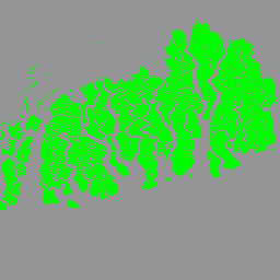
The CGMD-Extent30 (Continuous Global Mangrove Dynamics-Annual Mangrove Extent at 30-m resolution) dataset provides global annual mangrove extent from 1984 to 2023. The dataset is distributed as a single Earth Engine FeatureCollection, with each feature representing a mapped mangrove polygon for a specific year. The dataset … annual coastal forest-biomass global landsat-derived landuse-landcover -
Global Annual Mangrove Fractional Canopy Cover (1984-2023)
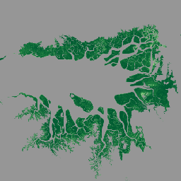
This dataset provides global annual mangrove fractional canopy cover (FCC) at 30-m spatial resolution from 1984 to 2023 to support large-scale analyses of long-term mangrove dynamics, including canopy degradation and recovery, blue carbon assessment, and coastal ecosystem monitoring. FCC quantifies the proportion of each Landsat … annual coastal forest-biomass global landsat-derived mangrove -
Global Mangrove Forests Distribution, v1 (2000)
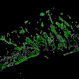
The database was prepared using Landsat satellite data from the year 2000. More than 1,000 Landsat scenes obtained from the USGS Earth Resources Observation and Science Center (EROS) were classified using hybrid supervised and unsupervised digital image classification techniques. This database is the first, most … annual ciesin forest-biomass global landsat-derived mangrove -
Murray Global Tidal Wetland Change v1.0 (1999-2019)
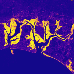
The Murray Global Tidal Wetland Change Dataset contains maps of the global extent of tidal wetlands and their change. The maps were developed from a three stage classification that sought to (i) estimate the global distribution of tidal wetlands (defined as either tidal marsh, tidal … coastal ecosystem intertidal landsat-derived mangrove murray