Page Summary
-
The awesome-gee-community-catalog is an unfunded open source project collecting community-sourced geospatial datasets.
-
Its mission is to make data accessible, tie it to an analysis platform, and reduce the digital divide.
-
The catalog offers openly available, preprocessed research datasets and frequently requested ones under various open licenses.
The Awesome GEE Community Catalog is an unfunded open source grassroots project with a mission to help collect community sourced and community generated geospatial datasets. Their goal is to make data accessible and tie it to an analysis platform fostering accessibility and reducing digital divide.
This catalog lives and serves alongside the Google Earth Engine data catalog. This collaborative effort not only offers openly available, preprocessed research datasets but also caters to frequently requested ones under various open licenses. You can find the full community catalog and access all datasets here.
-
GLOBathy Global lakes bathymetry dataset
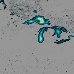
The GLObal Bathymetric (GLOBathy) dataset, comprising data on over 1.4 million waterbodies globally, has been meticulously developed to harmonize with the widely recognized HydroLAKES dataset. Utilizing a sophisticated Geographic Information System (GIS)-based framework, GLOBathy constructs detailed bathymetric maps by integrating maximum depth estimates and geometric/geophysical … bathymetry community-dataset hydrology sat-io surface-ground-water -
LandScan Population Data Global 1km
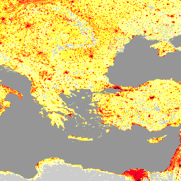
The LandScan dataset, provided by the Oak Ridge National Laboratory (ORNL), offers a comprehensive and high-resolution global population distribution dataset that serves as a valuable resource for a wide range of applications. Leveraging state-of-the-art spatial modeling techniques and advanced geospatial data sources, LandScan provides detailed … community-dataset demography landscan population sat-io -
United States Drought Monitor
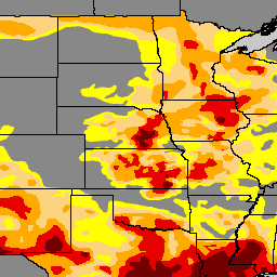
The U.S. Drought Monitor is a map released every Thursday, showing parts of the U.S. that are in drought. The map uses five classifications: abnormally dry (D0), showing areas that may be going into or are coming out of drought, and four levels of drought: … community-dataset drought noaa precipitation sat-io usda