
শুরু করা
- গুগল ম্যাপস প্ল্যাটফর্ম কী?
- আমি গুগল ম্যাপস প্ল্যাটফর্ম কীভাবে ব্যবহার শুরু করব?
- আমার কোন API-টি প্রয়োজন?
- আমার সাইটে এপিআই (API) ব্যবহার করা কীভাবে শুরু করব?
- গুগল ম্যাপস প্ল্যাটফর্ম কোন কোন দেশে পরিষেবা দেয়?
- আমি কি গুগল ম্যাপস প্ল্যাটফর্মের পণ্য ব্যবহার না করে আমার সাইটে গুগল ম্যাপস যুক্ত করতে পারি?
- মোবাইল ডিভাইসে ম্যাপস অ্যাপ্লিকেশন কীভাবে সরবরাহ করব?
- Maps JavaScript API এবং Maps Embed API কোন কোন ওয়েব ব্রাউজার সমর্থন করে?
- আমি কি Maps JavaScript API ব্যবহার করে মানচিত্র প্রিন্ট করতে পারি?
- গুগল ম্যাপস প্ল্যাটফর্মের পণ্যগুলিতে কোনো পরিবর্তন হলে আমি কীভাবে বিজ্ঞপ্তি পেতে পারি?
- আমি টেকনিক্যাল সাপোর্টের সাথে কীভাবে যোগাযোগ করব?
- কারিগরি সহায়তা কখন পাওয়া যাবে?
- আমি কীভাবে আমার গুগল অ্যাকাউন্টের অ্যাক্সেস পুনরুদ্ধার করব?
- আমি কীভাবে একটি নির্দিষ্ট প্রজেক্টের অ্যাক্সেস পুনরুদ্ধার করব?
- আমি কি Arm-ভিত্তিক Mac-এ iOS-এর জন্য Maps and Places SDK ব্যবহার করতে পারি?
পরিষেবার শর্তাবলী বুঝুন
- গুগল ম্যাপস প্ল্যাটফর্ম পণ্যগুলোর পরিষেবার শর্তাবলী কী?
- আমার সাইটটি কি গুগল ম্যাপস প্ল্যাটফর্মের পরিষেবার শর্তাবলী মেনে চলে?
- আমি কি সরাসরি মানচিত্রের টাইলস এবং স্যাটেলাইট চিত্রাবলী দেখতে পারি?
- আমি কি ট্র্যাকিং অ্যাপ্লিকেশনের জন্য গুগল ম্যাপস প্ল্যাটফর্মের পণ্যগুলো ব্যবহার করতে পারি?
- আমি কি আমার নন-ওয়েব অ্যাপ্লিকেশনে গুগল ম্যাপস প্ল্যাটফর্মের পণ্যগুলো ব্যবহার করতে পারি?
- পাসওয়ার্ড দ্বারা সুরক্ষিত কোনো সাইটে কি আমি গুগল ম্যাপস প্ল্যাটফর্মের প্রোডাক্টগুলো ব্যবহার করতে পারি?
- আমি কি এমন একটি অ্যাপ্লিকেশন তৈরি করতে পারি যাতে কোনো ডকুমেন্টে গুগল ম্যাপস প্ল্যাটফর্মের ডেটা অন্তর্ভুক্ত থাকে?
- গুগল সার্চ ফলাফলে আমার কন্টেন্ট অন্তর্ভুক্ত হওয়া থেকে আমি কীভাবে বিরত থাকতে পারি?
- আমি কি আমার ওয়েবসাইটে সংরক্ষণ ও পরিবেশন করা Maps Static API ব্যবহার করে একটি মানচিত্রের ছবি তৈরি করতে পারি?
ব্যবহারের সীমা এবং বিলিং
- আমার প্রোজেক্টের জন্য বিলিং কীভাবে সেট আপ করব?
- গুগল ক্লাউড ফ্রি ট্রায়াল কী এবং ফ্রি ট্রায়াল ব্যবহারকারীরা কীভাবে পেইড অ্যাকাউন্টে আপগ্রেড করতে পারেন?
- গুগল ম্যাপস প্ল্যাটফর্মের কি ব্যবহারের কোনো সীমা আছে?
- ব্যবহারের খরচ কীভাবে গণনা করা হয়?
- গুগল ম্যাপস প্ল্যাটফর্মে ম্যাপ লোড কীভাবে গণনা করা হয়?
- আমি কীভাবে আমার কোটা ব্যবহারের উপর নজর রাখব?
- ব্যবহারের সীমা অতিক্রম করলে কী হবে?
- আমার সাইটে প্রচুর ট্র্যাফিক আসে। আমি কি গুগল ম্যাপস প্ল্যাটফর্মের প্রোডাক্টগুলো ব্যবহার করতে পারি?
- আমার ওয়েবসাইট বা অ্যাপ্লিকেশন হঠাৎ জনপ্রিয় হয়ে উঠলে, আমার ম্যাপগুলো কি কাজ করা বন্ধ করে দেবে?
- ব্যবহার কীভাবে গণনা ও বিল করা হবে?
- গুগল ম্যাপস প্ল্যাটফর্ম ব্যবহার করতে কত খরচ হয়?
- অন্যান্য মুদ্রায় কি মূল্যতালিকা পাওয়া যায়?
- আমি বিলিং চালু করেছি। আমি আমার বিল কীভাবে দেখব?
- আমার ব্যবহার অপ্রত্যাশিতভাবে বেড়ে গেলে আমি কীভাবে বড় অঙ্কের বিল এড়াতে পারি?
- আমি একটি বার্তা পেয়েছি যেখানে বলা হয়েছে যে আমার প্রজেক্টটি "Google Maps Platform Transition Account"-এর সাথে লিঙ্ক করা আছে, কিন্তু আমার সেই অ্যাকাউন্টে অ্যাক্সেস নেই। এখন আমি কী করব?
- আমার কোটা সীমা প্রতিদিন ১টি অনুরোধে কেন সেট করা আছে? আমি কীভাবে এই সীমা বাড়াতে পারি?
- আমি বিলিং আইন লঙ্ঘনের একটি নোটিশ পেয়েছি। আমি কীভাবে এর সমাধান করব?
গুগল ম্যাপস প্ল্যাটফর্ম ব্যবহার করুন
- গুগল ম্যাপস প্ল্যাটফর্মের বিভিন্ন প্রোডাক্টের জন্য আমার কোন কী বা ক্রেডেনশিয়াল ব্যবহার করা উচিত?
- আমি কীভাবে আমার কী রেস্ট্রিকশন টাইপ HTTP রেফারার থেকে IP অ্যাড্রেস রেস্ট্রিকশনে পরিবর্তন করব?
- আমি কীভাবে একটি নতুন API কী পেতে পারি?
- গুগল ম্যাপস প্ল্যাটফর্মের প্রতিটি সংস্করণে আনা পরিবর্তনগুলো আমি কীভাবে খুঁজে পাব?
- পেজ লোড হওয়ার পর কীভাবে অ্যাসিঙ্ক্রোনাসভাবে এপিআই লোড করা যায়?
- আমি কীভাবে গুগল ম্যাপস প্ল্যাটফর্মের পণ্যগুলো ইংরেজি ছাড়া অন্য কোনো ভাষায় প্রদর্শন করতে পারি?
- HTTPS (TLS) এর মাধ্যমে কি গুগল ম্যাপস প্ল্যাটফর্ম অ্যাক্সেস করা যায়?
- গুগল ম্যাপস প্ল্যাটফর্মে আমি কীভাবে কোনো বাগ রিপোর্ট করব বা নতুন কোনো ফিচারের জন্য অনুরোধ করব?
- গুগল ম্যাপস প্ল্যাটফর্ম এপিআইগুলো কীভাবে সাইট কুকি ব্যবহার করে?
- আমি আমার প্রশ্নের উত্তর খুঁজে পাচ্ছি না। কার সাথে যোগাযোগ করব?
ত্রুটি এবং সমস্যা সমাধান
- এই ত্রুটিটির অর্থ কী?
- আমার মানচিত্রগুলো স্বাভাবিকের চেয়ে বেশি গাঢ় দেখাচ্ছে। কী হচ্ছে?
- আমি
OVER_DAILY_LIMITবাOVER_QUERY_LIMITএরর কোডগুলো কীভাবে সমাধান করব? - আমি কীভাবে
kGMSPlacesRateLimitExceededঅথবা9005 PLACES_API_RATE_LIMIT_EXCEEDEDএই এরর কোডগুলো সমাধান করব? - "এই আইপি, সাইট বা মোবাইল অ্যাপ্লিকেশনটি এই এপিআই কী ব্যবহার করার জন্য অনুমোদিত নয়" - এই ত্রুটিটি আমি কীভাবে সমাধান করব?
- "রেফারার সীমাবদ্ধতাযুক্ত এপিআই কী এই এপিআই-এর সাথে ব্যবহার করা যাবে না" এই ত্রুটিটি আমি কীভাবে সমাধান করব?
গুগল ম্যাপস প্ল্যাটফর্ম পরিষেবা
- আমাকে ঠিকানাগুলোকে অক্ষাংশ/দ্রাঘিমাংশ জোড়ায় রূপান্তর করতে হবে। আমি কি গুগল ম্যাপস প্ল্যাটফর্ম ব্যবহার করে তা করতে পারি?
- কোন কোন দেশে জিওকোডিং উপলব্ধ?
- গুগল ম্যাপস প্ল্যাটফর্মের জিওকোডারগুলো কেন গুগল ম্যাপসের চেয়ে ভিন্ন অবস্থান দেখায়?
- সফল অনুরোধের সংখ্যা সর্বাধিক করার জন্য আমার জিওকোডার কোয়েরিগুলো কীভাবে বিন্যাস করা উচিত?
- জিওকোডিংয়ের জন্য নম্বরযুক্ত হাইওয়েতে থাকা একটি মার্কিন ঠিকানা কীভাবে ফরম্যাট করব?
- কখন আমার এপিআই জিওকোডার ক্লাস এবং কখন এইচটিটিপি জিওকোডিং সার্ভিস ব্যবহার করা উচিত?
- গুগল ম্যাপস প্ল্যাটফর্মে আমি কীভাবে গাড়ি চালানোর দিকনির্দেশনা দেব?
- কোন কোন দেশে গাড়ি চালানোর দিকনির্দেশনা পাওয়া যায়?
- কোন কোন দেশে ট্রানজিট দিকনির্দেশনা পাওয়া যায়?
- Maps JavaScript API-তে কোন কোন KML এবং GeoRSS ফিচার সমর্থিত?
- Maps জাভাস্ক্রিপ্ট এপিআই-এর KmlLayer ক্লাস ব্যবহার করে প্রদর্শিত হতে পারে এমন KML ফাইলের আকার এবং জটিলতার সীমাবদ্ধতাগুলো কী কী?
- ইন্ট্রানেট সাইটে হোস্ট করা KML ফাইলগুলো মানচিত্রে কীভাবে রেন্ডার করব?
- Maps Static API সর্বোচ্চ কতগুলো মার্কার বা পাথ ভার্টেক্স সমর্থন করে?
- আমি কেন নির্দিষ্ট কিছু দেশের জন্য গুগল ম্যাপস প্ল্যাটফর্মের পণ্যগুলো ব্যবহার করতে পারছি না?
- গুগল বেসম্যাপে কোনো সমস্যা হলে কীভাবে জানাবো?
- Maps JavaScript API-এর সাথে ব্যবহৃত সার্ভিসগুলোর পারফরম্যান্স কীভাবে পর্যবেক্ষণ করা হয়?
মানচিত্র জাভাস্ক্রিপ্ট এপিআই
iOS-এর জন্য গুগল ম্যাপস এসডিকে
- আমি
kGMSPlacesRateLimitExceededত্রুটিটি কীভাবে সমাধান করব? - একটি iOS 8.x ডিভাইসে ডিবাগ করার সময় ক্র্যাশ হচ্ছে। আমার কী করা উচিত?
- গোলাকার এবং চওড়া স্ক্রিনের কারণে গুগল ম্যাপস আইওএস এসডিকে-এর উপর কী প্রভাব পড়ে?
অ্যান্ড্রয়েডের জন্য গুগল ম্যাপস এসডিকে
- আমি কীভাবে
9001 Operation failed due to exceeding the quota usage limitএই ত্রুটিটি সমাধান করব? - আমার অ্যাপটিতে ম্যাপের পরিবর্তে শুধু ফাঁকা ধূসর টাইলস দেখাচ্ছে। আমি এর সমাধান কীভাবে করতে পারি?
ইউআরএল স্বাক্ষর
- আমি কি জাভাস্ক্রিপ্ট ব্যবহার করে URL সাইন করতে পারি?
- আমার Maps API ওয়েব পরিষেবা অনুরোধগুলিতে কেন HTTP 403 Forbidden প্রতিক্রিয়া আসছে?
শুরু করা
- গুগল ম্যাপস প্ল্যাটফর্ম কী?
গুগল ম্যাপস প্ল্যাটফর্ম হলো এপিআই (API) এবং এসডিকে (SDK)-এর একটি সেট, যা ডেভেলপারদের মোবাইল অ্যাপ ও ওয়েব পেজে গুগল ম্যাপস যুক্ত করতে অথবা গুগল ম্যাপস থেকে ডেটা সংগ্রহ করতে সাহায্য করে। এর বিভিন্ন সংস্করণ রয়েছে। আপনার প্রয়োজন অনুযায়ী, আপনি এই এপিআই এবং এসডিকে-গুলোর একটি অথবা একাধিকের সমন্বয় ব্যবহার করতে পারেন।
মানচিত্র:
- মানচিত্র জাভাস্ক্রিপ্ট এপিআই
- অ্যান্ড্রয়েডের জন্য ম্যাপস এসডিকে
- iOS-এর জন্য ম্যাপস এসডিকে
- মানচিত্র টাইলস এপিআই
- এরিয়াল ভিউ এপিআই
- মানচিত্র স্ট্যাটিক এপিআই
- স্ট্রিট ভিউ স্ট্যাটিক এপিআই
- মানচিত্রের ইউআরএল
- মানচিত্র এমবেড এপিআই
- মানচিত্র ডেটাসেট এপিআই
পথসমূহ:
- রাউটস এপিআই
- রোডস এপিআই
- রুট অপ্টিমাইজেশন এপিআই
- অ্যান্ড্রয়েডের জন্য নেভিগেশন এসডিকে
- iOS এর জন্য নেভিগেশন SDK
স্থানসমূহ:
- স্থান এপিআই
- অ্যান্ড্রয়েডের জন্য প্লেসেস এসডিকে
- iOS-এর জন্য প্লেসেস এসডিকে
- প্লেসেস লাইব্রেরি, ম্যাপস জাভাস্ক্রিপ্ট এপিআই
- স্থান সমষ্টিগত এপিআই
- ঠিকানা যাচাইকরণ এপিআই
- জিওকোডিং এপিআই
- ভূ-অবস্থান এপিআই
- টাইম জোন এপিআই
পরিবেশ:
- আমি গুগল ম্যাপস প্ল্যাটফর্ম কীভাবে ব্যবহার শুরু করব?
- আমার কোন API-টি প্রয়োজন?
আপনার ফাংশনাল রিকোয়ারমেন্টের উপর ভিত্তি করে সঠিক API খুঁজে পেতে সাহায্যের জন্য, Capabilities Explorer-টি দেখুন।
- আমার সাইটে এপিআই (API) ব্যবহার করা কীভাবে শুরু করব?
আপনার আগ্রহের নির্দিষ্ট API বা SDK-এর জন্য Overview, Developer, এবং Get Started গাইডগুলো দেখুন। উদাহরণস্বরূপ, Maps SDK for Android বা Maps JavaScript API-এর গাইডগুলো দেখে নিন।
- গুগল ম্যাপস প্ল্যাটফর্ম কোন কোন দেশে পরিষেবা দেয়?
গুগল ম্যাপস টিম ক্রমাগত নতুন ম্যাপ ডেটা প্রকাশ করছে এবং আমাদের আন্তর্জাতিক কভারেজ বাড়াচ্ছে। সর্বশেষ কভারেজ তথ্যের জন্য গুগল ম্যাপস কভারেজ ডেটা দেখুন। আপনি পৃষ্ঠার শীর্ষে থাকা ফিল্টার বক্স ব্যবহার করে ডেটা ফিল্টার করতে পারেন। ডেটা সরবরাহকারীদের সাথে লাইসেন্সিং চুক্তি পরিবর্তিত হলে কভারেজ ডেটাও পরিবর্তিত হতে পারে।
আরও দেখুন:
- আমি কি গুগল ম্যাপস প্ল্যাটফর্মের পণ্য ব্যবহার না করে আমার সাইটে গুগল ম্যাপস যুক্ত করতে পারি?
হ্যাঁ। গুগল ম্যাপস এখন কোনো প্রোগ্রামিং বা গুগল ম্যাপস প্ল্যাটফর্ম ব্যবহার ছাড়াই আপনার দেখা মানচিত্রটি আপনার ওয়েবসাইট বা ব্লগে এম্বেড করার সুবিধা দিচ্ছে। আরও তথ্য এখানে পাওয়া যাবে।
- মোবাইল ডিভাইসে ম্যাপস অ্যাপ্লিকেশন কীভাবে সরবরাহ করব?
অ্যান্ড্রয়েড অ্যাপ্লিকেশনে ম্যাপ অন্তর্ভুক্ত করতে, অ্যান্ড্রয়েডের জন্য ম্যাপস এসডিকে (Maps SDK for Android ) ব্যবহার করুন।
একটি iOS অ্যাপ্লিকেশনে ম্যাপ অন্তর্ভুক্ত করতে, Maps SDK for iOS ব্যবহার করুন।
ম্যাপস জাভাস্ক্রিপ্ট এপিআইটি মোবাইল ডিভাইসের কথা মাথায় রেখে তৈরি করা হয়েছে এবং এটি ডেস্কটপ ও অ্যাপল আইফোনের মতো পূর্ণাঙ্গ জাভাস্ক্রিপ্ট ইমপ্লিমেন্টেশনযুক্ত ওয়েব ব্রাউজার থাকা ডিভাইস উভয়ের ব্রাউজার অ্যাপ্লিকেশনের জন্য উপযোগী।
যেসব ডিভাইস Maps JavaScript API ব্যবহারের জন্য উপযুক্ত নয়, সেগুলোর জন্য তৈরি অ্যাপ্লিকেশনগুলোতে Maps Static API , GIF, JPG, এবং PNG ফরম্যাটে ম্যাপ ইমেজ সরবরাহ করে, যার মধ্যে মার্কার এবং পলিলাইনও অন্তর্ভুক্ত থাকে। উল্লেখ্য যে, ব্রাউজার-ভিত্তিক অ্যাপ্লিকেশনের বাইরে Maps Static API ব্যবহার করতে হলে ম্যাপ ইমেজটিকে Google Maps-এর সাথে লিঙ্ক করা আবশ্যক।
- Maps JavaScript API এবং Maps Embed API কোন কোন ওয়েব ব্রাউজার সমর্থন করে?
Maps JavaScript API এবং Maps Embed API নিম্নলিখিত ওয়েব ব্রাউজারগুলিকে সমর্থন করে:
ডেস্কটপ- মাইক্রোসফট এজ (উইন্ডোজ)-এর বর্তমান সংস্করণ, আইই মোড ব্যতীত ।
- ফায়ারফক্সের সর্বশেষ দুটি প্রধান স্থিতিশীল সংস্করণ (উইন্ডোজ, ম্যাকওএস, লিনাক্স)।
- ক্রোমের সর্বশেষ দুটি প্রধান স্থিতিশীল সংস্করণ (উইন্ডোজ, ম্যাকওএস, লিনাক্স)।
- সাফারি (ম্যাকওএস)-এর সর্বশেষ দুটি প্রধান স্থিতিশীল সংস্করণ।
- অ্যান্ড্রয়েড ৪.১+ এ ক্রোমের বর্তমান সংস্করণ।
- অ্যান্ড্রয়েড ৪.৪+ এ ক্রোম ওয়েবভিউ।
- iOS-এর বর্তমান ও পূর্ববর্তী প্রধান সংস্করণগুলিতে মোবাইল সাফারি।
- iOS-এর বর্তমান এবং পূর্ববর্তী প্রধান সংস্করণগুলিতে UIWebView এবং WKWebView।
- iOS-এর জন্য Chrome-এর বর্তমান সংস্করণ।
- আমি কি Maps JavaScript API ব্যবহার করে মানচিত্র প্রিন্ট করতে পারি?
Maps JavaScript API থেকে প্রিন্ট করা সমর্থিত নয়। এর কারণ হলো, বহুল ব্যবহৃত ব্রাউজারগুলোতে প্রিন্টিং সাপোর্ট সামঞ্জস্যপূর্ণ নয়।
- গুগল ম্যাপস প্ল্যাটফর্মের পণ্যগুলিতে কোনো পরিবর্তন হলে আমি কীভাবে বিজ্ঞপ্তি পেতে পারি?
গুগল জিও-এর বিভিন্ন ডেভেলপার অফারিং সম্পর্কিত খবরের আপডেট পেতে আপনার গুগল ম্যাপস প্ল্যাটফর্ম ব্লগে সাবস্ক্রাইব করা উচিত।
- আমি টেকনিক্যাল সাপোর্টের সাথে কীভাবে যোগাযোগ করব?
উপলব্ধ সহায়তা বিকল্পগুলো সম্পর্কে তথ্যের জন্য গুগল ম্যাপস প্ল্যাটফর্ম সাপোর্ট ও রিসোর্স দেখুন।
- কারিগরি সহায়তা কখন পাওয়া যাবে?
- আঞ্চলিক ছুটির দিনগুলো বাদে, 'পরিষেবা অনুপযোগী' সমস্যার জন্য সাপোর্ট টিম সপ্তাহের ৫ দিনই ২৪ ঘন্টা (টোকিও সময় সোমবার সকাল ৯টা থেকে প্যাসিফিক সময় শুক্রবার বিকাল ৫টা পর্যন্ত) উপলব্ধ থাকে।
- আমি কীভাবে আমার গুগল অ্যাকাউন্টের অ্যাক্সেস পুনরুদ্ধার করতে পারি?
আপনি যদি আপনার গুগল অ্যাকাউন্টের (যেমন joe@mycompany.com বা joe@gmail.com) অ্যাক্সেস হারিয়ে ফেলেন, তাহলে আপনার পাসওয়ার্ড পুনরুদ্ধার বা রিসেট করে অ্যাকাউন্টের অ্যাক্সেস ফিরিয়ে আনার চেষ্টা করতে পারেন। গুগল অ্যাকাউন্ট হেল্প-এ থাকা ‘How to recover your Google Account or Gmail’ আর্টিকেলটি দেখুন।
- দ্রষ্টব্য: একটি G Suite অ্যাকাউন্টে অ্যাক্সেস পুনরুদ্ধার করতে, আপনার প্রতিষ্ঠানের অ্যাডমিনিস্ট্রেটরকে অ্যাকাউন্টটি আনডিলিট করার জন্য অনুরোধ করুন।
- আমি কীভাবে একটি নির্দিষ্ট প্রজেক্টে অ্যাক্সেস পুনরুদ্ধার করতে পারি?
যে প্রজেক্টে আপনি আপনার গুগল ম্যাপস প্ল্যাটফর্ম বাস্তবায়ন পরিচালনা করেন, সেটির অ্যাক্সেস যদি হারিয়ে ফেলেন, তবে আপনি তা পুনরুদ্ধার করার চেষ্টা করতে পারেন।
আপনার প্রকল্পের সাথে যুক্ত গুগল অ্যাকাউন্টে যদি আপনার প্রবেশাধিকার থাকে:
- আপনি যদি প্রজেক্টের মালিককে চেনেন এবং আপনার গুগল অ্যাকাউন্টে প্রবেশাধিকার থাকে, তাহলে তাকে আপনাকে প্রজেক্টের মালিক বা সম্পাদক হিসেবে যুক্ত করতে বলুন।
- আপনার প্রজেক্টটি যদি কোনো অর্গানাইজেশনের অংশ হয়, তাহলে আপনার অর্গানাইজেশনের অ্যাডমিনদের সাথে যোগাযোগ করুন এবং আপনাকে প্রজেক্ট ওনার হিসেবে যুক্ত করতে বলুন।
- আপনি যদি বর্তমান প্রজেক্ট ওনারদের কাউকে না চেনেন: যদি আপনি না জানেন প্রজেক্ট ওনার কে, অথবা তিনি অনুপস্থিত থাকেন, তাহলে প্রজেক্টটি পুনরুদ্ধারের জন্য অতিরিক্ত বিকল্পগুলো খতিয়ে দেখতে সাপোর্ট টিমের সাথে যোগাযোগ করুন ।
আপনার প্রকল্পের সাথে যুক্ত গুগল অ্যাকাউন্টে যদি আপনার প্রবেশাধিকার না থাকে:
- আপনি যদি আপনার গুগল অ্যাকাউন্টের অ্যাক্সেস হারিয়ে ফেলেন, তবে আপনার অ্যাকাউন্টের ইউজারনেম বা পাসওয়ার্ড পুনরুদ্ধার করার চেষ্টা করুন ।
- আপনি যদি আপনার গুগল অ্যাকাউন্টের অ্যাক্সেস পুনরুদ্ধার করতে না পারেন: একটি নতুন গুগল অ্যাকাউন্ট তৈরি করুন, তারপর প্রকল্পের বর্তমান মালিকের সাথে যোগাযোগ করে আপনার নতুন গুগল অ্যাকাউন্টটি প্রকল্পে যুক্ত করতে বলুন।
- আপনি যদি প্রজেক্টের মালিককে চেনেন এবং আপনার গুগল অ্যাকাউন্টে প্রবেশাধিকার থাকে, তাহলে তাকে আপনাকে প্রজেক্টের মালিক বা সম্পাদক হিসেবে যুক্ত করতে বলুন।
- আমি কি Arm-ভিত্তিক Mac-এ iOS-এর জন্য Maps and Places SDK ব্যবহার করতে পারি?
নতুন Arm-ভিত্তিক ম্যাকগুলিতে ডেভেলপ করা সম্ভব, তবে এর জন্য একটি বাস্তব iOS ডিভাইসে বিল্ড ও রান করতে হবে। এটি একটি অস্থায়ী সীমাবদ্ধতা, কারণ আমরা সিমুলেটরে ডেভেলপ করার জন্য আরও সাপোর্ট যোগ করার বিষয়টি খতিয়ে দেখছি।
পরিষেবার শর্তাবলী বুঝুন
- গুগল ম্যাপস প্ল্যাটফর্ম পণ্যগুলোর পরিষেবার শর্তাবলী কী?
গুগল ম্যাপস প্ল্যাটফর্মের পরিষেবার শর্তাবলী এখানে পাওয়া যাবে:
- আমার সাইটটি কি গুগল ম্যাপস প্ল্যাটফর্মের পরিষেবার শর্তাবলী মেনে চলে?
আপনার সাইটটি গুগল ম্যাপস প্ল্যাটফর্মের পরিষেবার শর্তাবলী মেনে চললে, আপনি আপনার অ্যাপ্লিকেশনগুলিতে গুগল ম্যাপস প্ল্যাটফর্ম ব্যবহার করতে পারবেন।
তবে, গুগল ম্যাপস প্ল্যাটফর্মের এমন কিছু ব্যবহার রয়েছে যা আমরা একেবারেই দেখতে চাই না। উদাহরণস্বরূপ, কোনো শহরে অবৈধ মাদক কেনার জায়গা বা অন্য কোনো অবৈধ কার্যকলাপ চিহ্নিতকারী মানচিত্র। আমরা মানুষের গোপনীয়তাকেও সম্মান করি, তাই কোনো ব্যক্তির ব্যক্তিগত তথ্য শনাক্ত করার জন্য গুগল ম্যাপস প্ল্যাটফর্ম ব্যবহার করা উচিত নয়।
আপনার অ্যাপ্লিকেশনটি তৈরি ও চালু করার আগে, সেটি গুগল ম্যাপস প্ল্যাটফর্মের পরিষেবার শর্তাবলী মেনে চলে কিনা তা নির্ধারণ করতে আপনার নিজস্ব আইনজীবীর সাহায্য নেওয়া উচিত। গুগলের প্রকৌশলীরা শুধুমাত্র প্রযুক্তিগত সহায়তা প্রদান করতে পারেন এবং তারা আইনি পরামর্শ দেওয়ার জন্য যোগ্য নন। গুগল যেকোনো সময় আপনার পরিষেবা ব্যবহার স্থগিত বা বন্ধ করার অধিকার সংরক্ষণ করে, তাই ম্যাপস এপিআই-এর শর্তাবলী মনোযোগ সহকারে পড়ুন।
- আমি কি সরাসরি মানচিত্রের টাইলস এবং স্যাটেলাইট চিত্রাবলী দেখতে পারি?
আপনি গুগল ম্যাপস প্ল্যাটফর্ম ছাড়া অন্য কোনো পদ্ধতির মাধ্যমে (যেমন আপনার নিজস্ব ম্যাপিং এপিআই তৈরি করা বা বাল্ক টাইল ডাউনলোড স্ক্রিপ্ট ব্যবহার করে) ম্যাপ টাইলস বা স্যাটেলাইট চিত্র অ্যাক্সেস করতে পারবেন না। আপনার অ্যাপ্লিকেশনটি গুগল ম্যাপস প্ল্যাটফর্মের বাইরে থেকে টাইলস অ্যাক্সেস করলে, সেটির অ্যাক্সেস ব্লক করে দেওয়া হবে। আরও বিস্তারিত জানতে গুগল ম্যাপস প্ল্যাটফর্মের পরিষেবার শর্তাবলী দেখুন।
- আমি কি ট্র্যাকিং অ্যাপ্লিকেশনের জন্য গুগল ম্যাপস প্ল্যাটফর্মের পণ্যগুলো ব্যবহার করতে পারি?
গুগল ম্যাপস প্ল্যাটফর্মের পরিষেবার শর্তাবলী মেনে চললে, এর প্রোডাক্টগুলোর মাধ্যমে রিয়েল-টাইম ডেটা (ট্র্যাকিং) প্রদর্শনে কোনো বিধিনিষেধ নেই।
- আমি কি আমার নন-ওয়েব অ্যাপ্লিকেশনে গুগল ম্যাপস ব্যবহার করতে পারি?
হ্যাঁ, গুগল ম্যাপস প্ল্যাটফর্মের পণ্যগুলো এখন নন-ওয়েব অ্যাপ্লিকেশনেও ব্যবহার করা যাবে, তবে শর্ত হচ্ছে যে সেগুলোকে গুগল ম্যাপস প্ল্যাটফর্মের পরিষেবার শর্তাবলীর অন্যান্য বিধিনিষেধ মেনে চলতে হবে।
Maps JavaScript API শুধুমাত্র সমর্থিত ব্রাউজারগুলোর কোনো একটিতে চালালেই কাজ করে।
- পাসওয়ার্ড দ্বারা সুরক্ষিত কোনো সাইটে কি আমি গুগল ম্যাপস প্ল্যাটফর্মের প্রোডাক্টগুলো ব্যবহার করতে পারি?
হ্যাঁ, গুগল ম্যাপস, রুটস, প্লেসেস এবং এনভায়রনমেন্ট পরিষেবাগুলো প্রাইভেট-অ্যাক্সেস অ্যাপ্লিকেশনগুলোর সাথে ব্যবহার করা যায়। আরও বিস্তারিত জানতে গুগল ম্যাপস প্ল্যাটফর্মের পরিষেবার শর্তাবলী দেখুন।
- আমি কি এমন একটি অ্যাপ্লিকেশন তৈরি করতে পারি যাতে কোনো ডকুমেন্টে গুগল ম্যাপস প্ল্যাটফর্মের ডেটা অন্তর্ভুক্ত থাকে?
আপনার অ্যাপ্লিকেশনটি যদি ইলেকট্রনিক বা মুদ্রিত আকারে কোনো ডকুমেন্ট তৈরি করে, তবে সেই ডকুমেন্টে গুগল ম্যাপস প্ল্যাটফর্মের কোনো ডেটা, ছবি সহ, অন্তর্ভুক্ত করা যাবে না। আরও বিস্তারিত জানতে গুগল ম্যাপস প্ল্যাটফর্মের পরিষেবার শর্তাবলীর "নো স্ক্র্যাপিং" বিভাগটি দেখুন।
- গুগল সার্চ ফলাফলে আমার কন্টেন্ট অন্তর্ভুক্ত হওয়া থেকে আমি কীভাবে বিরত থাকতে পারি?
আমরা আর এই ডেটা সংগ্রহ করছি না।
indexingপ্যারামিটারটির ব্যবহার অপ্রচলিত হয়ে গেছে এবং এর কোনো কার্যকারিতা নেই। আপনাকে আর স্পষ্টভাবে অপ্ট-আউট করার প্রয়োজন নেই, তবে আমরা আপনাকে যত তাড়াতাড়ি সম্ভব এই প্যারামিটারটি সরিয়ে ফেলার জন্য উৎসাহিত করছি।অনুসন্ধানের ফলাফল থেকে আপনার পৃষ্ঠা বা সাইট সরাতে, আমাদের সহায়তা কেন্দ্রে দেওয়া নির্দেশাবলী অনুসরণ করুন।
- আমি কি আমার ওয়েবসাইটে সংরক্ষণ ও পরিবেশন করা Maps Static API ব্যবহার করে একটি মানচিত্রের ছবি তৈরি করতে পারি?
আপনি আপনার ওয়েবসাইট থেকে ম্যাপস স্ট্যাটিক এপিআই (Maps Static API) ব্যবহার করে তৈরি করা ছবির অনুলিপি সংরক্ষণ এবং পরিবেশন করতে পারবেন না। যে সমস্ত ওয়েব পেজে স্ট্যাটিক ছবির প্রয়োজন, সেগুলিতে অবশ্যই একটি HTML
imgট্যাগেরsrcঅ্যাট্রিবিউট অথবা একটি HTMLdivট্যাগের CSSbackground-imageঅ্যাট্রিবিউটকে সরাসরি ম্যাপস স্ট্যাটিক এপিআই-এর সাথে লিঙ্ক করতে হবে, যাতে সমস্ত মানচিত্রের ছবি ওয়েব পেজের HTML কন্টেন্টের মধ্যে প্রদর্শিত হয় এবং গুগলের মাধ্যমে সরাসরি ব্যবহারকারীদের কাছে পরিবেশিত হয়।
ব্যবহারের সীমা এবং বিলিং
- আমার প্রোজেক্টের জন্য বিলিং কীভাবে সেট আপ করব?
- গুগল ম্যাপস প্ল্যাটফর্ম দিয়ে কীভাবে শুরু করবেন তা দেখুন।
- গুগল ক্লাউড ফ্রি ট্রায়াল কী এবং ফ্রি ট্রায়াল ব্যবহারকারীরা কীভাবে পেইড অ্যাকাউন্টে আপগ্রেড করতে পারেন?
গুগল ক্লাউড ফ্রি ট্রায়াল হলো একটি ৯১-দিনের প্রোগ্রাম, যা নতুন ব্যবহারকারীদের কোনো আর্থিক দায়বদ্ধতা ছাড়াই গুগল ম্যাপস প্ল্যাটফর্ম (জিএমপি) এপিআই-সহ গুগল ক্লাউডের সবচেয়ে জনপ্রিয় প্রোডাক্টগুলো ব্যবহার করে দেখার সুযোগ দেয়। ফ্রি ট্রায়ালের জন্য সাইন আপ করলে একটি ফ্রি ট্রায়াল বিলিং অ্যাকাউন্ট তৈরি হয়, যেখানে আগে থেকেই ৩০০ ডলারের ফ্রি ওয়েলকাম ক্রেডিট লোড করা থাকে, যা আপনি জিএমপি-তে খরচ করতে পারবেন।
যদি ৯১ দিন অতিবাহিত হওয়ার আগে আপনি একটি পেইড বিলিং অ্যাকাউন্টে আপগ্রেড না করেন অথবা আপনার ৩০০ ডলারের ফ্রি ক্রেডিট খরচ করে ফেলেন, তাহলে আপনার ফ্রি ট্রায়াল বিলিং অ্যাকাউন্টটি বন্ধ করে দেওয়া হবে এবং এর সাথে যুক্ত সমস্ত প্রজেক্ট ও রিসোর্স বন্ধ হয়ে যাবে। ফ্রি ট্রায়াল চলাকালীন আপনার তৈরি করা রিসোর্স এবং পরিষেবাগুলো নিরবচ্ছিন্নভাবে চালু রাখতে, একটি পেইড বিলিং অ্যাকাউন্টে আপগ্রেড করুন । ফ্রি ট্রায়াল সম্পর্কে আরও পড়ুন।
- গুগল ম্যাপস প্ল্যাটফর্মের কি ব্যবহারের কোনো সীমা আছে?
গুগল ম্যাপস প্ল্যাটফর্মের পণ্যগুলিতে আপনি দৈনিক যত খুশি অনুরোধ করতে পারেন, এর কোনো সর্বোচ্চ সীমা নেই এবং ব্যবহারের একমাত্র সীমাবদ্ধতা হলো প্রতি মিনিটে সর্বোচ্চ সংখ্যক কোয়েরি (QPM)।
নিচের সারণিতে প্রতিটি এপিআই (API)-এর ব্যবহারের সীমা দেখানো হয়েছে। আপনি ক্লাউড কনসোলে কোটার সীমা দেখতে ও পরিবর্তন করতে পারেন।
এপিআই ব্যবহারের সীমা ঠিকানা যাচাইকরণ ৬,০০০ কিউপিএম আকাশ থেকে দৃশ্য: লুকআপ ভিডিও ১৮০ কিউপিএম এবং ১০০,০০০ কিউপিডি আকাশ থেকে দৃশ্য: রেন্ডার ভিডিও ১০০ কিউপিএম এবং ১০০ কিউপিডি বায়ুর গুণমান ৬,০০০ কিউপিএম ম্যাপস জাভাস্ক্রিপ্ট এপিআই: ত্রিমাত্রিক মানচিত্র ৩০,০০০ কিউপিএম মানচিত্র জাভাস্ক্রিপ্ট এপিআই: ডাইনামিক মানচিত্র ৩০,০০০ কিউপিএম উচ্চতা ৬,০০০ কিউপিএম জিওকোডিং ৩,০০০ কিউপিএম ভূ-অবস্থান ৬,০০০ কিউপিএম ম্যাপস গ্রাউন্ডিং লাইট ৩০০ কিউপিএম ম্যাপ টাইলস এপিআই: ২ডি ম্যাপ টাইলস ৬,০০০ কিউপিএম এবং ১৫,০০০ কিউপিডি মানচিত্র টাইলস এপিআই: স্ট্রিট ভিউ টাইলস ৬,০০০ কিউপিএম এবং ১৫,০০০ কিউপিডি ম্যাপ টাইলস এপিআই: ফটোরিয়ালিস্টিক ৩ডি টাইলস প্রতিদিন ১২,০০০ কিউপিএম এবং ১০,০০০ রুট রিকোয়েস্ট। নেভিগেশন: গন্তব্য অনুরোধ সেট করুন ৩০,০০০ কিউপিএম স্থান ৬,০০০ কিউপিএম স্থান সমষ্টি ১,২০০ কিউপিএম পরাগরেণু ৬,০০০ কিউপিএম রাস্তা ৩০,০০০ কিউপিএম রুট: রুট গণনা করুন ৩,০০০ কিউপিএম রুট: রুট ম্যাট্রিক্স গণনা করুন ৩,০০০ ইপিএম সৌর ৬০০ কিউপিএম স্থির মানচিত্র ৩০,০০০ কিউপিএম স্ট্রিট ভিউ ইমেজ এপিআই ৩০,০০০ কিউপিএম সময় অঞ্চল ৩০,০০০ কিউপিএম আবহাওয়া ৬,০০০ কিউপিএম ব্যয় নিয়ন্ত্রণ করতে, আপনি আপনার এপিআই (API) ব্যবহার নিরীক্ষণ করতে পারেন এবং যেকোনো বিলযোগ্য এপিআই-এর সমস্ত অনুরোধের জন্য দৈনিক সীমা নির্ধারণ করতে পারেন ।
গুগল ম্যাপস প্ল্যাটফর্মের পণ্যগুলো অবশ্যই গুগল ম্যাপস প্ল্যাটফর্মের সাধারণ পরিষেবার শর্তাবলী মেনে স্থাপন করতে হবে।
- ব্যবহারের খরচ কীভাবে গণনা করা হয়?
গুগল ম্যাপস প্ল্যাটফর্ম পণ্যগুলির মূল্য সম্পর্কে সার্বিক ধারণা পেতে মূল্য তালিকাটি দেখুন।
গুগল ম্যাপস প্ল্যাটফর্ম এপিআই-এর বিলিং কীভাবে করা হয় সে সম্পর্কে আরও জানতে, গুগল ম্যাপস প্ল্যাটফর্মের বিলিং এবং মূল্য নির্ধারণের সংক্ষিপ্ত বিবরণ দেখুন।
- গুগল ম্যাপস প্ল্যাটফর্মে ম্যাপ লোড কীভাবে গণনা করা হয়?
নিম্নলিখিত যেকোনো একটি ঘটলে একটি ম্যাপ লোডের জন্য চার্জ প্রযোজ্য হবে:
- একটি ওয়েব পেজ বা অ্যাপ্লিকেশন Maps JavaScript API ব্যবহার করে একটি মানচিত্র প্রদর্শন করে।
- একটি অ্যাপ্লিকেশন ম্যাপস স্ট্যাটিক এপিআই (Maps Static API) থেকে একটি একক মানচিত্রের ছবির জন্য অনুরোধ করে।
স্ট্রিট ভিউ প্যানোরামার জন্য ম্যাপ লোড করার থেকে আলাদাভাবে চার্জ করা হয়:
- একটি স্ট্যাটিক (নন-ইন্টারেক্টিভ) স্ট্রিট ভিউ প্যানোরামা এম্বেড করার জন্য স্ট্রিট ভিউ স্ট্যাটিক এপিআই-তে করা প্রতিটি অনুরোধের জন্য চার্জ প্রযোজ্য।
- Maps JavaScript API, Maps SDK for Android, বা Maps SDK for iOS অ্যাপ্লিকেশনে প্যানোরামা অবজেক্টের প্রতিটি ইনস্ট্যানসিয়েশনের জন্য একটি ডাইনামিক স্ট্রিট ভিউ প্যানোরামার চার্জ প্রযোজ্য।
কোনো ওয়েব পেজ বা অ্যাপ্লিকেশন একটি মানচিত্র, বা একটি স্থির মানচিত্রের ছবি, বা একটি স্ট্রিট ভিউ প্যানোরামা লোড করার পরে, ব্যবহারকারীর করা যেকোনো মিথস্ক্রিয়া, যেমন প্যানিং, জুমিং, বা মানচিত্রের স্তর পরিবর্তন করা, অতিরিক্ত কোনো মানচিত্র লোড করে না বা ব্যবহারের সীমাকে প্রভাবিত করে না।
একটি মার্কার যোগ করলে অতিরিক্ত ম্যাপ লোড হবে না, কিন্তু পিনের অবস্থান কীভাবে নির্ধারণ করা হয়েছে তার ওপর ভিত্তি করে চার্জ তৈরি হতে পারে (যেমন
google.maps.Map()ক্লাসটি লোড বা রিলোড করা)।- আমি কীভাবে আমার ব্যবহার নিরীক্ষণ করব?
আপনি গুগল ক্লাউড কনসোলে স্বতন্ত্র এপিআইগুলোর ব্যবহার নিরীক্ষণ করতে পারেন।
- যে প্রজেক্টটিতে আপনি পর্যালোচনা করতে চান এমন API রয়েছে, সেটি নির্বাচন করুন।
- ড্যাশবোর্ডে থাকা API-এর তালিকা থেকে API-টির নামে ক্লিক করুন।
- পৃষ্ঠার উপরের দিকে, মেট্রিক্স বা কোটা-তে ক্লিক করুন।
একটি সম্পূর্ণ প্রকল্পের ট্র্যাফিক রিপোর্ট ও বিলিং তথ্য দেখতে, এই ধাপগুলো অনুসরণ করুন:
- যদি আপনি ইতিমধ্যে তা না করে থাকেন, তাহলে বিলিং সেট আপ করুন ।
- ক্লাউড কনসোল বিলিং পৃষ্ঠায় যান।
- একটি প্রকল্প নির্বাচন করুন।
- বাম সাইডবারে, রিপোর্টস-এ ক্লিক করুন। আপনার বিলিং অ্যাকাউন্টের রিপোর্ট দেখতে ডান সাইডবারের ফিল্টারগুলো ব্যবহার করুন।
আরও জানতে, গুগল ম্যাপস প্ল্যাটফর্ম রিপোর্টিং , গুগল ম্যাপস প্ল্যাটফর্ম মনিটরিং এবং কোটা সীমা নির্ধারণ দেখুন।
- আমি অনুরোধের হার (QPM) সীমা অতিক্রম করলে কী হবে?
আপনি যদি কোনো নির্দিষ্ট গুগল ম্যাপস প্ল্যাটফর্ম প্রোডাক্টের QPM সীমা অতিক্রম করেন, তাহলে API একটি ত্রুটি বার্তা দেখাবে। আপনি যদি বারবার এই সীমা অতিক্রম করেন, তাহলে API-তে আপনার প্রবেশাধিকার সাময়িকভাবে ব্লক করা হতে পারে।
আপনি যদি অনুরোধের QPM সীমা অতিক্রম করেন বা অন্য কোনোভাবে পরিষেবাটির অপব্যবহার করেন, তাহলে অনুরোধগুলোতে একটি নির্দিষ্ট ত্রুটির বার্তা প্রদর্শিত হবে। আপনি যদি ক্রমাগত সীমা অতিক্রম করতে থাকেন, তাহলে গুগল ম্যাপস প্ল্যাটফর্মে আপনার প্রবেশাধিকার অবরুদ্ধ করা হতে পারে।
দ্রষ্টব্য: নিম্নলিখিত ওয়েব সার্ভিস এপিআইগুলোর সমতুল্য ক্লায়েন্ট-সাইড সার্ভিস ম্যাপস জাভাস্ক্রিপ্ট এপিআই-তে উপলব্ধ আছে: এলিভেশন , জিওকোডিং ।
ব্যবহারের সীমা অতিক্রম করা হয়েছে
ব্যবহারের সীমা অতিক্রম করলে আপনি প্রতিক্রিয়া হিসাবে একটি
OVER_QUERY_LIMITস্ট্যাটাস কোড পাবেন।এই বার্তার অর্থ হলো, ওয়েব পরিষেবাটি স্বাভাবিক প্রতিক্রিয়া দেওয়া বন্ধ করে দিয়েছে এবং পুনরায় ব্যবহারের অনুমতি না দেওয়া পর্যন্ত শুধুমাত্র
OVER_QUERY_LIMITস্ট্যাটাস কোডটি ফেরত দিচ্ছে। এই পরিস্থিতি কয়েক সেকেন্ডের মধ্যেই ঘটতে পারে, যদি আপনার অ্যাপ্লিকেশনটি প্রতি মিনিটে খুব বেশি অনুরোধ পাঠানোর কারণে ত্রুটিটি এসে থাকে।আপনি যদি নিয়মিত আপনার QPM ব্যবহারের সীমা অতিক্রম করেন, তাহলে Google Maps Platform-এর পণ্যগুলো আরও দক্ষতার সাথে ব্যবহার করার জন্য অ্যাপ্লিকেশনগুলোকে অপ্টিমাইজ করে ব্যবহার কমানোর কথা বিবেচনা করুন, অথবা আপনার কোটা বাড়ানোর জন্য অনুরোধ করুন। আরও তথ্যের জন্য অপ্টিমাইজেশন গাইড দেখুন।
- আমার সাইটে প্রচুর ট্র্যাফিক আসে। আমি কি গুগল ম্যাপস প্ল্যাটফর্মের প্রোডাক্টগুলো ব্যবহার করতে পারি?
হ্যাঁ। তবে আমরা আপনাকে পরামর্শ দিচ্ছি যে, আপনার অ্যাপ্লিকেশনটি গুগল ম্যাপস প্ল্যাটফর্মের যে অংশগুলোর ওপর নির্ভর করে, সেগুলোর ব্যবহারের সীমা সম্পর্কে আপনি জেনে নিন।
- আমার ওয়েবসাইট বা অ্যাপ্লিকেশন হঠাৎ জনপ্রিয় হয়ে উঠলে, আমার ম্যাপগুলো কি কাজ করা বন্ধ করে দেবে?
আপনার একটি বিলিং অ্যাকাউন্ট থাকলে, যদি আপনি বিনামূল্যে ব্যবহারের সীমা অতিক্রম করেন এবং আপনার বিলিং অ্যাকাউন্টে কোনো বৈধ অর্থপ্রদানের পদ্ধতি (যেমন ক্রেডিট কার্ড বা ব্যাংক ট্রান্সফার) না থাকে, তাহলে একটি বৈধ অর্থপ্রদানের পদ্ধতি যোগ না করা পর্যন্ত API-টি কাজ করা বন্ধ করে দেয়।
- ব্যবহার কীভাবে গণনা ও বিল করা হবে?
প্রতিদিনের শেষে ব্যবহারের পরিমাণ গণনা করা হয় এবং মূল্যতালিকায় দেখানো অনুযায়ী তার মূল্য নির্ধারণ করা হয়। প্রতি মাসের শেষে, আপনার বিলিং অ্যাকাউন্টের সাথে যুক্ত পেমেন্ট পদ্ধতিতে মোট ব্যবহারের পরিমাণ চার্জ করা হয়। আরও তথ্যের জন্য, গুগল ম্যাপস প্ল্যাটফর্ম বিলিং দেখুন।
- গুগল ম্যাপস প্ল্যাটফর্ম ব্যবহার করতে কত খরচ হয়?
প্রতিটি এপিআই-এর খরচের একটি সার্বিক ধারণা পেতে মূল্য তালিকা দেখুন। যদি আপনার অ্যাপ্লিকেশনটি কোনো নির্দিষ্ট মাসের জন্য নির্ধারিত বিনামূল্যে ব্যবহারের সর্বোচ্চ সীমা পর্যন্ত অনুরোধ বা ম্যাপ লোড ভলিউম তৈরি করে, তবে আপনার ব্যবহারের জন্য কোনো চার্জ করা হবে না। বিনামূল্যে ব্যবহারের সীমা অতিক্রম করলে, আপনার বিলিং অ্যাকাউন্টে চার্জ করা হবে। আরও বিস্তারিত জানতে, গুগল ম্যাপস প্ল্যাটফর্ম বিলিং দেখুন।
- অন্যান্য মুদ্রায় কি মূল্যতালিকা পাওয়া যায়?
কনসোলে অতিরিক্ত মুদ্রা উপলব্ধ থাকতে পারে। আপনি যখন একটি ভিন্ন মুদ্রা নির্বাচন করবেন, তখন আমাদের মূল্য তালিকা (Pricing Sheet) -তে তালিকাভুক্ত USD সমতুল্য মূল্য থেকে রেট রূপান্তরিত হবে।
- আমি বিলিং চালু করেছি। আমি আমার বিল কীভাবে দেখব?
গুগল প্রতি মাসের শুরুতে, আপনার নির্দিষ্ট করা পেমেন্ট পদ্ধতি ব্যবহার করে, পূর্ববর্তী মাসের কার্যকলাপের জন্য আপনাকে চার্জ করে। আপনার বিল সম্পর্কে বিস্তারিত জানতে, আমাদের গুগল ম্যাপস প্ল্যাটফর্ম বিলিং দেখুন।
অতিরিক্ত সম্পদ:
- আপনার খরচ এবং পরিশোধের ইতিহাস কীভাবে দেখবেন তা জেনে নিন।
- কীভাবে ইনভয়েস বা পেমেন্ট রসিদ পেতে হয় তা জানুন।
- বিলিং অ্যালার্ট কীভাবে সেট ও পরিচালনা করতে হয় তা জানুন।
- আমার ব্যবহার অপ্রত্যাশিতভাবে বেড়ে গেলে আমি কীভাবে বড় অঙ্কের বিল এড়াতে পারি?
গুগল ম্যাপস প্ল্যাটফর্ম দৈনিক অনুরোধের সীমা এবং সর্বোচ্চ দৈনিক বিলযোগ্য সীমা নির্ধারণ করার উপায় প্রদান করে। অপ্রত্যাশিত বৃদ্ধি থেকে সুরক্ষার জন্য আপনি ব্যবহারের সর্বোচ্চ দৈনিক সীমা বেঁধে দিতে পারেন। এছাড়াও, বিলিং অ্যাকাউন্টের চার্জ আপনার সেট করা একটি নির্দিষ্ট সীমায় পৌঁছালে ইমেল বিজ্ঞপ্তি পাওয়ার জন্য আপনি বাজেট অ্যালার্ট সেট করতে পারেন।
দৈনিক বিলযোগ্য সর্বোচ্চ সীমা নির্ধারণ করা:
বড় অঙ্কের বিল এড়াতে, ব্যবহারের অপ্রত্যাশিত বৃদ্ধি থেকে সুরক্ষার জন্য আপনি দৈনিক ব্যবহারের উপর একটি সীমা নির্ধারণ করতে পারেন। আপনি ক্লাউড কনসোলে এই সীমাটি পরিবর্তন করতে পারবেন।
বাজেট সতর্কতা নির্ধারণ ও পরিচালনা:
আপনার সেট করা থ্রেশহোল্ডে বিলিং অ্যাকাউন্টের চার্জ পৌঁছালে বিলিং অ্যাডমিনিস্ট্রেটরদের ইমেল নোটিফিকেশন পাঠানোর জন্য বাজেট অ্যালার্ট সেট আপ করুন । বিলিং অ্যাকাউন্টের আনুমানিক চার্জ থ্রেশহোল্ডের ৫০%, ৯০% এবং ১০০% অতিক্রম করলে বিলিং অ্যাডমিনিস্ট্রেটরদের ইমেল নোটিফিকেশন পাঠানো হবে।
- আমি একটি বার্তা পেয়েছি যেখানে বলা হয়েছে যে আমার প্রজেক্টটি "Google Maps Platform Transition Account"-এর সাথে লিঙ্ক করা আছে, কিন্তু আমার সেই অ্যাকাউন্টে অ্যাক্সেস নেই। এখন আমি কী করব?
নির্দিষ্ট কিছু গ্রাহককে আমাদের পে-অ্যাজ-ইউ-গো প্রাইসিং প্ল্যানে স্থানান্তরিত হতে সাহায্য করার জন্য "গুগল ম্যাপস প্ল্যাটফর্ম ট্রানজিশন অ্যাকাউন্ট" তৈরি করা হয়েছিল। এই ট্রানজিশন অ্যাকাউন্টটি গুগলকে এই গ্রাহকদের একটি এককালীন ক্রেডিট প্রদান করতে সক্ষম করেছে, যাতে তারা নো-চার্জ টায়ারের সীমা পর্যন্ত গুগল ম্যাপস প্ল্যাটফর্ম ব্যবহার চালিয়ে যেতে পারেন। এই সীমা অতিক্রম করলে, বিলিং অ্যাকাউন্টটি বন্ধ হয়ে যাবে এবং আপনি পরিষেবাটিতে অ্যাক্সেস হারাবেন। পরিষেবা বিঘ্ন এড়াতে, আমরা আপনাকে আপনার নিজস্ব বিলিং অ্যাকাউন্ট সেট করতে এবং প্রতি মাসে বিনামূল্যে ব্যবহারের নির্ধারিত সীমা উপভোগ করা চালিয়ে যেতে অনুরোধ করছি। আপনার প্রোজেক্টের জন্য বিলিং অ্যাকাউন্ট পরিবর্তন করতে:
- একটি নতুন বিলিং অ্যাকাউন্ট তৈরি করুন (যদি আপনার আগে থেকেই একটি বিলিং অ্যাকাউন্ট থাকে, তবে আপনি এই ধাপটি এড়িয়ে যেতে পারেন)।
- আপনার প্রকল্পের সাথে বিলিং অ্যাকাউন্টটি সংযুক্ত করুন ।
- আমার কোটা সীমা প্রতিদিন ১টি অনুরোধে কেন সেট করা আছে? আমি কীভাবে এই সীমা বাড়াতে পারি?
আপনি যদি আপনার প্রোজেক্টে একটি বিলিং অ্যাকাউন্ট তৈরি করে সংযুক্ত না করে থাকেন, তাহলে আপনার ম্যাপস প্ল্যাটফর্ম এপিআই (Maps Platform APIs) প্রতিদিন ১টি অনুরোধে সীমাবদ্ধ থাকবে। একটি বিলিং অ্যাকাউন্ট তৈরি করে এবং সংযুক্ত করার মাধ্যমে আপনি উচ্চতর কোটা পেতে পারেন। এটি করার জন্য, “গুগল ম্যাপস প্ল্যাটফর্ম দিয়ে শুরু করুন” (Get Started with Google Maps Platform ) দেখুন।
একবার আপনি একটি বিলিং অ্যাকাউন্ট তৈরি করে সংযুক্ত করলে, আপনার দৈনিক কোটার সীমা তুলে দেওয়া হবে। অপ্রত্যাশিত খরচ রোধ করতে, আপনি ক্লাউড কনসোলে একটি সীমা নির্ধারণ করার সিদ্ধান্ত নিতে পারেন।
- আমি বিলিং আইন লঙ্ঘনের একটি নোটিশ পেয়েছি। আমি কীভাবে এর সমাধান করব?
আপনি এই বিজ্ঞপ্তিটি পেয়েছেন কারণ গুগল শনাক্ত করেছে যে আপনার অ্যাকাউন্ট একাধিক বিলিং অ্যাকাউন্ট ব্যবহার করছে। এটি গুগল ম্যাপস প্ল্যাটফর্ম পরিষেবার শর্তাবলীতে সংজ্ঞায়িত গুগলের শর্তাবলীর একটি লঙ্ঘন। এই শর্তাবলী অনুসারে, একাধিক বিলিং অ্যাকাউন্ট তৈরি করা নিষিদ্ধ। আরও জানতে, বিলিং অ্যাকাউন্ট লঙ্ঘন সম্পর্কিত প্রায়শই জিজ্ঞাসিত প্রশ্নাবলী (FAQ ) দেখুন।
গুগল ম্যাপস প্ল্যাটফর্ম ব্যবহার করুন
- বিভিন্ন ম্যাপস প্রোডাক্টের জন্য আমার কোন কী বা ক্রেডেনশিয়াল ব্যবহার করা উচিত?
প্রতিবার গুগল ম্যাপস প্ল্যাটফর্ম পণ্য ব্যবহার করার সময়, আপনার অনুরোধ যাচাই করার জন্য আপনাকে অবশ্যই একটি এপিআই কী অন্তর্ভুক্ত করতে হবে। গুগল ম্যাপস প্ল্যাটফর্ম অ্যান্ড্রয়েড, আইওএস বা ওয়েব অ্যাপ এবং এইচটিটিপি ওয়েব পরিষেবার জন্য উপলব্ধ।
এপিআই কী:
- এপিআই কী হলো একটি অনন্য শনাক্তকারী যা আপনি ক্লাউড কনসোল ব্যবহার করে তৈরি করেন।
- একটি কী ব্যবহার করে এপিআই লোড করার উদাহরণ:
&key=AIzaSyBjsINSH5x39Ks6c0_CoS1yr1Mb3cB3cVo
ডিজিটাল স্বাক্ষর:
- গুগল কর্তৃক আপনাকে প্রদত্ত একটি ইউআরএল সাইনিং সিক্রেট ব্যবহার করে একটি ডিজিটাল স্বাক্ষর তৈরি করা হয়। ডিজিটাল স্বাক্ষর ম্যাপস স্ট্যাটিক এপিআই এবং স্ট্রিট ভিউ স্ট্যাটিক এপিআই-এর সাথে ব্যবহৃত হয়।
সীমাবদ্ধতা:
- এপিআই কী সীমাবদ্ধ করা ঐচ্ছিক, কিন্তু অধিকতর নিরাপত্তার জন্য আমরা আপনাকে সমস্ত এপিআই কী সীমাবদ্ধ করার জন্য দৃঢ়ভাবে সুপারিশ করি। আরও বিস্তারিত জানতে এপিআই নিরাপত্তার সর্বোত্তম অনুশীলনসমূহ দেখুন।
- আপনি এপিআই কী-তে একটি অ্যাপ্লিকেশন সীমাবদ্ধতা যোগ করতে পারেন। একবার সীমাবদ্ধ করা হলে, একটি কী শুধুমাত্র সেইসব প্ল্যাটফর্মে কাজ করবে যেগুলো সেই ধরনের সীমাবদ্ধতা সমর্থন করে। চার ধরনের অ্যাপ্লিকেশন সীমাবদ্ধতা উপলব্ধ আছে। একই ধরনের সীমাবদ্ধতা প্রয়োগকারী এপিআইগুলো একই সীমাবদ্ধ কী ব্যবহার করতে পারে।
- আইপি অ্যাড্রেস (স্বতন্ত্র সার্ভারসমূহ) - ওয়েব সার্ভিস এপিআই-এর সাথে ব্যবহারের জন্য।
- HTTP রেফারার (ওয়েবসাইট) - ওয়েব এপিআই-এর সাথে ব্যবহারের জন্য।
- অ্যান্ড্রয়েড অ্যাপের উপর সীমাবদ্ধতা (প্যাকেজ নাম এবং ফিঙ্গারপ্রিন্ট দ্বারা) - অ্যান্ড্রয়েডের জন্য ম্যাপস এসডিকে (Maps SDK for Android) -এর সাথে ব্যবহারের জন্য।
- iOS অ্যাপের উপর সীমাবদ্ধতা (iOS বান্ডেল আইডেন্টিফায়ার দ্বারা) - iOS-এর জন্য Maps SDK-এর সাথে ব্যবহারের জন্য।
- আপনি এপিআই কী-তে একটি এপিআই সীমাবদ্ধতাও যোগ করতে পারেন। আরও তথ্যের জন্য, “একটি এপিআই কী পান, যোগ করুন এবং সীমাবদ্ধ করুন” দেখুন।
নিচের সারণিতে প্রতিটি গুগল ম্যাপস প্ল্যাটফর্ম এপিআই/এসডিকে-এর জন্য কী/ক্রেডেনশিয়াল এবং অ্যাপ্লিকেশন সীমাবদ্ধতা উল্লেখ করা হয়েছে।
এপিআই/এসডিকে পরিচয়পত্র এবং আবেদন সীমাবদ্ধতা অ্যান্ড্রয়েডের জন্য ম্যাপস এসডিকে অ্যান্ড্রয়েড সীমাবদ্ধতা ১ সহ এপিআই কী অ্যান্ড্রয়েডের জন্য প্লেসেস এসডিকে অ্যান্ড্রয়েড সীমাবদ্ধতা ১ সহ এপিআই কী অ্যান্ড্রয়েডের জন্য নেভিগেশন এসডিকে অ্যান্ড্রয়েড সীমাবদ্ধতা ১ সহ এপিআই কী iOS-এর জন্য ম্যাপস এসডিকে iOS সীমাবদ্ধতা ১ সহ এপিআই কী iOS-এর জন্য প্লেসেস এসডিকে iOS সীমাবদ্ধতা ১ সহ এপিআই কী iOS এর জন্য নেভিগেশন SDK iOS সীমাবদ্ধতা ১ সহ এপিআই কী মানচিত্র জাভাস্ক্রিপ্ট এপিআই HTTP রেফারার সীমাবদ্ধতা ১ সহ এপিআই কী মানচিত্র টাইলস এপিআই আইপি অ্যাড্রেস সীমাবদ্ধতাসহ এপিআই কী ১ মানচিত্র ডেটাসেট এপিআই OAuth টোকেন এরিয়াল ভিউ এপিআই আইপি অ্যাড্রেস সীমাবদ্ধতাসহ এপিআই কী ১ মানচিত্র স্ট্যাটিক এপিআই HTTP রেফারার সীমাবদ্ধতা ১ সহ এপিআই কী + ডিজিটাল স্বাক্ষর ২ স্ট্রিট ভিউ স্ট্যাটিক এপিআই HTTP রেফারার সীমাবদ্ধতা ১ সহ এপিআই কী + ডিজিটাল স্বাক্ষর ২ মানচিত্র এমবেড এপিআই HTTP রেফারার সীমাবদ্ধতা ১ সহ এপিআই কী ঠিকানা যাচাইকরণ এপিআই আইপি অ্যাড্রেস সীমাবদ্ধতাসহ এপিআই কী ১ এলিভেশন এপিআই আইপি অ্যাড্রেস সীমাবদ্ধতাসহ এপিআই কী ১ জিওকোডিং এপিআই আইপি অ্যাড্রেস সীমাবদ্ধতাসহ এপিআই কী ১ ভূ-অবস্থান এপিআই আইপি অ্যাড্রেস সীমাবদ্ধতাসহ এপিআই কী ১ স্থান এপিআই আইপি অ্যাড্রেস সীমাবদ্ধতাসহ এপিআই কী ১ স্থান সমষ্টিগত এপিআই আইপি অ্যাড্রেস সীমাবদ্ধতাসহ এপিআই কী ১ রোডস এপিআই আইপি অ্যাড্রেস সীমাবদ্ধতাসহ এপিআই কী ১ রাউটস এপিআই আইপি অ্যাড্রেস সীমাবদ্ধতাসহ এপিআই কী ১ টাইম জোন এপিআই আইপি অ্যাড্রেস সীমাবদ্ধতাসহ এপিআই কী ১ বায়ুর গুণমান এপিআই আইপি অ্যাড্রেস সীমাবদ্ধতাসহ এপিআই কী ১ পরাগরেণু এপিআই আইপি অ্যাড্রেস সীমাবদ্ধতাসহ এপিআই কী ১ সৌর এপিআই আইপি অ্যাড্রেস সীমাবদ্ধতাসহ এপিআই কী ১ আবহাওয়া এপিআই আইপি অ্যাড্রেস সীমাবদ্ধতাসহ এপিআই কী ১ ১. এপিআই কী-এর উপর বিধিনিষেধ আরোপ করা ঐচ্ছিক, কিন্তু অধিকতর নিরাপত্তার জন্য আমরা আপনাকে সকল এপিআই কী সীমাবদ্ধ করার জন্য দৃঢ়ভাবে সুপারিশ করছি।২ ব্যবহারের উপর নির্ভর করে, ম্যাপস স্ট্যাটিক এপিআই এবং স্ট্রিট ভিউ স্ট্যাটিক এপিআই-এর জন্য একটি ডিজিটাল স্বাক্ষরের প্রয়োজন হতে পারে। ব্যবহার নির্বিশেষে, আমরা দৃঢ়ভাবে সুপারিশ করি যে আপনি আপনার অনুরোধগুলি প্রমাণীকরণের জন্য একটি এপিআই কী এবং একটি ডিজিটাল স্বাক্ষর উভয়ই ব্যবহার করুন।- আমি কীভাবে আমার কী রেস্ট্রিকশন টাইপ HTTP রেফারার থেকে IP অ্যাড্রেস রেস্ট্রিকশনে পরিবর্তন করব?
গুরুত্বপূর্ণ: আপনি যদি রেফারার সীমাবদ্ধতাযুক্ত কোনো এপিআই কী দিয়ে ওয়েব সার্ভিস এপিআই ব্যবহার করেন, তাহলে আপনার অনুরোধগুলো এই ত্রুটি বার্তা সহ ব্যর্থ হবে: "এই এপিআই-এর সাথে ব্যবহারের জন্য এপিআই কী-তে রেফারার সীমাবদ্ধতা থাকতে পারে না।" আপনার আইপি অ্যাড্রেস সীমাবদ্ধতাযুক্ত এপিআই কী ব্যবহার করা উচিত।
এপিআই কী-এর সীমাবদ্ধতার ধরণ HTTP রেফারার থেকে আইপি অ্যাড্রেসে পরিবর্তন করার আগে, নিশ্চিত করুন যে এপিআই কী ব্যবহারকারী সমস্ত এপিআই আইপি সীমাবদ্ধতার ধরণ সমর্থন করে। একই সীমাবদ্ধতার ধরনের এপিআই একই সীমাবদ্ধ কী ব্যবহার করতে পারে। যদি আপনাকে একাধিক সীমাবদ্ধতা প্রয়োগ করতে হয়, তাহলে প্রয়োজনীয় সীমাবদ্ধতাসহ একটি পৃথক কী যোগ করুন। একটি নতুন এপিআই কী কীভাবে যোগ করতে হয় তা দেখুন।
গুগল ম্যাপস প্ল্যাটফর্ম পণ্যগুলির সাথে সম্পর্কিত এপিআই কী সীমাবদ্ধতা সম্পর্কে আরও জানুন।
HTTP রেফারার সীমাবদ্ধতাযুক্ত একটি API কী-কে IP অ্যাড্রেস সীমাবদ্ধতায় পরিবর্তন করতে, নিম্নলিখিতগুলি করুন:
- ক্লাউড কনসোলের ক্রেডেনশিয়ালস পৃষ্ঠায় যান।
- যে প্রজেক্টটিতে আপনি সম্পাদনা করতে চান এমন API কী রয়েছে, সেটি নির্বাচন করুন।
- ক্রেডেনশিয়ালস পেজে, এপিআই কী-গুলোর তালিকা থেকে, কী-টির বিবরণ সম্পাদনা করার জন্য এপিআই কী-টির নামটি নির্বাচন করুন।
- পেজের "Key restriction" সেকশনে, "IP addresses (web servers, cron jobs, etc.)" সিলেক্ট করুন এবং উপযুক্ত সার্ভার আইপি অ্যাড্রেসগুলো প্রবেশ করান, তারপর "Save"-এ ক্লিক করুন।
- আমি কীভাবে একটি নতুন API কী পেতে পারি?
- গুগল ম্যাপস প্ল্যাটফর্ম দিয়ে কীভাবে শুরু করবেন তা দেখুন।
- গুগল ম্যাপস এপিআই-এর প্রতিটি সংস্করণে আনা পরিবর্তনগুলো আমি কীভাবে খুঁজে পাব?
অনেকগুলো ম্যাপস এপিআই-এর ভার্সন পরিবর্তনের তথ্য নিম্নলিখিত লিঙ্কগুলিতে পাওয়া যাবে:
- জিওকোডিং এপিআই
- মানচিত্র জাভাস্ক্রিপ্ট এপিআই
- রাউটস এপিআই
- অ্যান্ড্রয়েডের জন্য ম্যাপস এসডিকে
- অ্যান্ড্রয়েডের জন্য প্লেসেস এসডিকে
- অ্যান্ড্রয়েডের জন্য নেভিগেশন এসডিকে
- iOS-এর জন্য ম্যাপস এসডিকে
- iOS-এর জন্য প্লেসেস এসডিকে
- iOS এর জন্য নেভিগেশন SDK
- স্থান এপিআই
- স্থান সমষ্টিগত এপিআই
- ঠিকানা যাচাইকরণ এপিআই
- এরিয়াল ভিউ এপিআই
- বায়ুর গুণমান এপিআই
- পরাগরেণু এপিআই
- সৌর এপিআই
- মানচিত্র টাইলস এপিআই
- মানচিত্র ডেটাসেট এপিআই
- আবহাওয়া এপিআই
এছাড়াও, কোনো নির্দিষ্ট বাগ Google Maps Platform-এর কোন সংস্করণে যুক্ত ও সমাধান করা হয়েছিল, তা আপনি Google Maps Platform Issue Tracker-এ গিয়ে যাচাই করতে পারেন:
- পেজ লোড হওয়ার পর কীভাবে অ্যাসিঙ্ক্রোনাসভাবে এপিআই লোড করা যায়?
এপিআই লোড করার সময় শুধু কলব্যাক প্যারামিটারটি নির্দিষ্ট করে দিন। আরও তথ্য এবং নমুনা কোড ম্যাপস জাভাস্ক্রিপ্ট এপিআই ডকুমেন্টেশনের ' গেটিং স্টার্টেড' বিভাগে পাওয়া যাবে।
- আমি কীভাবে গুগল ম্যাপস প্ল্যাটফর্মের পণ্যগুলো ইংরেজি ছাড়া অন্য কোনো ভাষায় প্রদর্শন করতে পারি?
By default the API will attempt to load the most appropriate language based on the users location or browser settings. Some APIs allow you to explicitly set a language when you make a request. More information on how to set the language is available in the documentation for each API:
Supported Languages:Google often updates supported languages. This list may not be exhaustive and is subject to change.
Language Code ভাষা Language Code ভাষা আফ আফ্রিকান জা জাপানি বর্গ আলবেনিয়ান kn কন্নড় সকাল আমহারিক কেকে কাজাখ আর আরবি কিমি খেমার হাই আর্মেনীয় কো কোরিয়ান আজ আজারবাইজানীয় কি কিরগিজ ইউরোপীয় ইউনিয়ন বাস্ক লো লাও হতে বেলারুশীয় এলভি লাতভিয়ান বিএন বাংলা এলটি লিথুয়ানিয়ান বিএস বসনীয় এমকে ম্যাসিডোনিয়ান বিজি বুলগেরীয় এমএস মালয় আমার বর্মী এমএল মালয়ালম ca কাতালান মিঃ মারাঠি zh চীনা এমএন মঙ্গোলীয় zh-CN চীনা (সরলীকৃত) নে নেপালি zh-HK চীনা (হংকং) না নরওয়েজিয়ান zh-TW Chinese (Traditional) পিএল পোলিশ এইচআর ক্রোয়েশীয় পিটি পর্তুগিজ সিএস চেক পিটি-বিআর পর্তুগিজ (ব্রাজিল) দা ড্যানিশ পিটি-পিটি পর্তুগিজ (পর্তুগাল) এনএল ডাচ পা পাঞ্জাবি ইংরেজি ইংরেজি রো রোমানিয়ান en-AU ইংরেজি (অস্ট্রেলিয়ান) রু রাশিয়ান en-GB ইংরেজি (গ্রেট ব্রিটেন) এসআর সার্বিয়ান (সিরিলিক) et এস্তোনিয়ান sr-Latn Serbian (Latin script) ফা ফারসি সি সিংহলী ফি ফিনিশ এসকে স্লোভাক ফিল ফিলিপিনো এসএল স্লোভেনীয় ফ্র ফরাসি ইএস স্প্যানিশ fr-CA ফরাসি (কানাডা) ইএস-৪১৯ স্প্যানিশ (লাতিন আমেরিকা) জিএল গ্যালিসিয়ান এসডব্লিউ সোয়াহিলি ka জর্জিয়ান এসভি সুইডিশ ডি জার্মান ta তামিল এল গ্রীক তে তেলুগু গু গুজরাটি তম থাই আইডব্লিউ হিব্রু ট্র তুর্কি হাই হিন্দি যুক্তরাজ্য ইউক্রেনীয় হু হাঙ্গেরীয় উর উর্দু is আইসল্যান্ডীয় উজ উজবেক আইডি ইন্দোনেশিয়ান vi ভিয়েতনামী এটা ইতালীয় জু জুলু You can see what the map will look like in any of the languages listed above in this sample application .
- Can the Google Maps Platform be accessed over HTTPS (TLS)?
All Google Maps Platform can and should be accessed over HTTPS. To future proof your applications, we strongly recommend that you use TLS 1.3 for HTTPS. Although older TLS versions are still supported, we advice against relying on the deprecated legacy TLS versions 1.0 and 1.1.
The deprecated SSL protocol is no longer supported.
For more information, see the Google Maps Platform Root CA Migration FAQ and the Google Trust Services FAQ .
- How do I report a bug or request a new feature in Google Maps Platform?
If you experience behavior that you believe may be a bug, begin by raising it in the relevant forum . This will allow other developers to validate the bug, and rule out any potential issues with your code.
To request a feature, first raise it in the relevant forum to confirm that a solution that meets your requirements is not already available.
Once you have confirmed that you have identified a new bug, or that your requirements cannot be met by the existing functionality of Google Maps Platform products, report your bug or feature request using the Google Maps Platform Issue Tracker .
Before adding a bug or feature request to the Issue Tracker ,be sure to check that the bug or feature concerned has not already been added. If it has, you can star the issue to register your interest and be notified of updates.
Maps SDK for Android and Maps SDK for iOS use cookies subject to Google's Privacy Policy , such as calculating daily and 7-day active users and service abuse prevention. These cookies are not associated with any signed-in Google Account and are not logged with the rest of the information collected from the API calls.
- I can't find the answer to my question. Who should I contact?
Google's Developer Relations team maintains a presence on Stack Overflow — a collaboratively-edited question and answer site for programmers. It's a great place to ask technical questions about developing and maintaining Google Maps applications. More information about asking questions on Stack Overflow is available on the Support page.
For best results when requesting help, keep the following in mind:
- Search the current discussions. Chances are someone else has experienced a similar issue and found a fix.
- Submit a link to your site if possible. Only post code snippets if the code is not viewable online.
- Provide all relevant information including browser versions, errors, and all other facts that may be useful in troubleshooting this problem.
Errors and troubleshooting
- What does this error mean?
If you encounter an error while loading or running the Google Maps APIs, see the following links to find explanations for the error codes:
- My maps appear darker than usual. What's happening?
Under certain circumstances, a darkened map, or 'negative' Street View image, watermarked with the text "for development purposes only", may be displayed. This behavior typically indicates issues with either an API key or billing. To use Google Maps Platform products, you must have a billing account and all requests must include a valid API key. The following flow will help troubleshoot this:
- How do I resolve the error codes:
OVER_DAILY_LIMITorOVER_QUERY_LIMIT? - These error codes can be returned for any of the following reasons:
- An API key is missing from the request.
- The provided API key is invalid.
- The project does not have a billing account attached.
- A self-imposed usage cap has been exceeded.
- প্রদত্ত অর্থপ্রদানের পদ্ধতিটি আর বৈধ নয় (উদাহরণস্বরূপ, ক্রেডিট কার্ডের মেয়াদ শেষ হয়ে গেছে)।
- You have exceeded the quota limits for a given API.
To use Google Maps Platform products, you must have a billing account, and all requests must include a valid API key. To fix this, take the following steps:
- Set up a billing account .
- Get a new API key .
- Adjust your usage cap to increase your daily quota limit (if applicable).
- How do I resolve the error codes:
kGMSPlacesRateLimitExceededor9005 PLACES_API_RATE_LIMIT_EXCEEDED? - If you are seeing
kGMSPlacesRateLimitExceededor9005 PLACES_API_RATE_LIMIT_EXCEEDED, you may be using a deprecated version of the Places SDK for Android or Places SDK for iOS. Learn more and find the new SDKs at https://goo.gle/places-sdk-deprecation . - How do I resolve the error: "This IP, site or mobile application is not authorized to use this API key."?
There are various scenarios which may cause this error:
- You've enabled IP address (server) restrictions on your API key, and an unauthorized IP address is attempting a request.
- You've enabled HTTP referrer (website) restrictions on your API key, and an unauthorized referrer is attempting a request.
- You've restricted usage to your Android apps by setting a package name and fingerprint, and an unauthorized Android app is attempting a request.
- You've restricted requests from iOS apps by specifying bundle identifiers and an unrecognized iOS app is attempting to send a request.
- It used to be possible to get this error if you used any of the web service APIs , with an API key with HTTP referer restrictions. Requests to those APIs should be identified with an API key with IP address restrictions. Switch your key restriction type from an HTTP referer restriction to an IP address restriction . For more information about restricting API keys, see API Key Best Practices .
View and Edit your API Key Credentials
To view your API keys and manage any restrictions, do the following:
- Go to the Credentials page of the Cloud console.
- Select the project that contains the API key you want to review.
- To view credential details, including any restrictions set for the key, from the list of API keys, click the name of the key.
- The full credentials of the selected API key are displayed, including any restrictions set up for the key. From here, the restrictions can be changed, deleted, or updated as needed.
- How do I resolve the error: "API keys with referer restrictions cannot be used with this API."?
You are using any of the web service APIs with an API key restricted to an HTTP referer. For security reasons, web service APIs need to use API keys restricted to IP addresses . Switch your key restriction type from an HTTP referer restriction to an IP address restriction , or create a new API key if your key is already used with the Maps JavaScript API.
Google Maps Platform Services
- I need to convert addresses to latitude/longitude pairs. Can I do that with Google Maps Platform?
Yes, this process is called "geocoding." The Maps JavaScript API includes a class for performing a geocoding service. The class is: google.maps.Geocoder .
Alternatively, Google also provides the Geocoding API , which offers a REST interface that can respond in JSON and XML formats.
- Which countries is geocoding available in?
To see countries supported by Google Maps Platform geocoders, consult the Google Maps coverage data .
The accuracy of geocoded locations may vary per country, so you should consider using the returned location_type field to determine if a good enough match has been found for the purposes of your application. The availability of geocoding data depends on our contracts with data providers, so it is subject to change.
- Why do Google Maps Platform Geocoders provide different locations than Google Maps?
The API geocoder and Google Maps geocoder sometimes use different data sets (depending on the country). The API geocoder occasionally gets updated with new data, so you can expect to see results changing or improving over time.
- How should I format my geocoder queries to maximise the number of successful requests?
The geocoder is designed to map street addresses to geographical coordinates. We therefore recommend that you format geocoder requests in accordance with the following guidelines to maximize the likelihood of a successful query:
- Specify addresses in accordance with the format used by the national postal service of the country concerned.
- don't specify additional address elements such as business names, unit numbers, floor numbers, or suite numbers that are not included in the address as defined by the postal service of the country concerned. Doing so may result in responses with
ZERO_RESULTS. - Format plus codes as shown here (plus signs are url-escaped to
%2Band spaces are url-escaped to%20):- global code is a 4 character area code and 6 character or longer local code (849VCWC8+R9 is
849VCWC8%2BR9). - compound code is a 6 character or longer local code with an explicit location (CWC8+R9 Mountain View, CA, USA is
CWC8%2BR9%20Mountain%20View%20CA%20USA).
- global code is a 4 character area code and 6 character or longer local code (849VCWC8+R9 is
- Use the street number of a premise in preference to the building name where possible.
- Use street number addressing in preference to specifying cross streets where possible.
- don't provide 'hints' such as nearby landmarks.
- How should I format a US address on a numbered highway for geocoding?
The Google Maps Platform geocoder requires that US numbered highways be specified in addresses as follows:
- County Roads:
"Co Road NNN "where NNN is the road number. eg."Co Road 82" - State Highways:
" State NNN "where State is the full name of the state and NNN is the highway number. eg."California 82" - US Highways:
"US NNN "where NNN is the highway number. eg."US 101" - US Interstates:
"Interstate NNN "where NNN is the interstate number. eg."Interstate 280"
- County Roads:
- When should I use an API geocoder class and when should I use the HTTP Geocoding Service?
See the document: Geocoding Strategies , which details the advantages and limitations of different geocoding strategies.
- How do I provide driving directions with Google Maps Platform?
The Compute Routes service of the Routes API lets you provide driving directions for single and multi-leg journeys. Routing options help you shape directions with a travel mode (driving), a single or a set of routes, and restrictions (no toll roads). These services are available in the following forms:
HTTP request/response interface (used in mobile and other applications) is compatible with Maps SDK for Android and with other Google Maps web services.
- In which countries are driving directions available?
To see countries supported by driving directions in Google Maps Platform products, consult the Google Maps coverage data . The availability of driving directions data depends on our contracts with data providers, and is subject to change.
- In which countries are transit directions available?
The Routes API supports all Google Transit partners , except the Indian Railway Catering and Tourism Corporation and those in Japan.
- Which KML and GeoRSS features are supported in the Maps JavaScript API?
The KmlLayer class in the Maps JavaScript API enables developers to overlay KML/KMZ and GeoRSS files on top of the map. For documentation and examples, see KmlLayer class .
- What are the limits on the size and complexity of KML that can be displayed using the KmlLayer class of the Maps JavaScript API?
The size and complexity limits on the display of KML using the
KmlLayerclass are documented KmlLayer overview .- How do I render KML files that are hosted on intranet sites on a map?
The
KmlLayerclass that generates KML overlays in the Maps JavaScript API uses a Google hosted service to retrieve and parse KML files for rendering. Consequently it is not possible to display KML files that are not hosted at a URL that is available publicly accessible, or that require authentication to access.If you need to develop applications that use KML files hosted on intranet sites we recommend that you render the KML on the client side by using third-party JavaScript libraries. As the KML file is analyzed by the browser, performance may be lower than by using the
KmlLayerclass.- What is the maximum number of markers or path vertices supported by the Maps Static API?
There is no limit to the number of markers or path vertices supported by the Maps Static API. When using custom icons, up to five unique icons can be specified per request, but each can be used multiple times within the map.
Note that Maps Static API URLs can contain a maximum of approximately 8,192 characters which constrains the number of markers and path vertices that can be specified based on the number of decimal places used when specifying each latitude/longitude pair. For information on how the number of decimal places used relates to the accuracy on the Earth see the Wikipedia article on Decimal Degrees .
- Why can't I access Google Maps Platform products for certain countries?
Maps APIs may not be used in Prohibited Territories . Refer also to the Terms of Service .
- How do I report a problem on the Google basemap?
- Send feedback through Google Maps for wrong or missing map information such as:
- Wrong addresses or marker locations
- Incorrect road names
- Wrong information about one-way and two-way roads
- Incorrectly drawn road
- বন্ধ রাস্তা
- Roads that don't exist
For correction of a place or business listing, suggest an edit .
If Maps content needs to be removed for legal reasons, submit a legal request.
For critical or time-sensitive requests, file a support case with specific details on what needs to be fixed.
Some client-side features are instrumented to report success or failure for the purpose of calculating the SLO (Service Level Objective). This information is sent to Google at maps.googleapis.com/maps_api_js_slo/log in calls that log SLO information. This information includes success status, latency, and version/channel of the Maps JavaScript API in use. The calls may be batched for performance. You may need to allow maps.googleapis.com in your Content Security Policy so that these calls are not blocked at browser-level. For example: Content-Security-Policy: default-src 'self' maps.googleapis.com; with HTTP headers, or <meta http-equiv="Content-Security-Policy" content="default-src 'self' maps.googleapis.com;"> with HTML Meta Tags.
Maps JavaScript API
- How long will the Maps JavaScript API work after it has been loaded?
You need to refresh the page that loads the Maps JavaScript API at least once every 5 days.
Google Maps SDK for iOS
- How do I resolve the error:
kGMSPlacesRateLimitExceeded? - If you are seeing this error, you may be using a deprecated version of the Places SDK for iOS. Version 2.7.0 of the Places SDK for iOS has been turned off, and is no longer available. Update your app to use the latest version as soon as possible. See the migration guide for details.
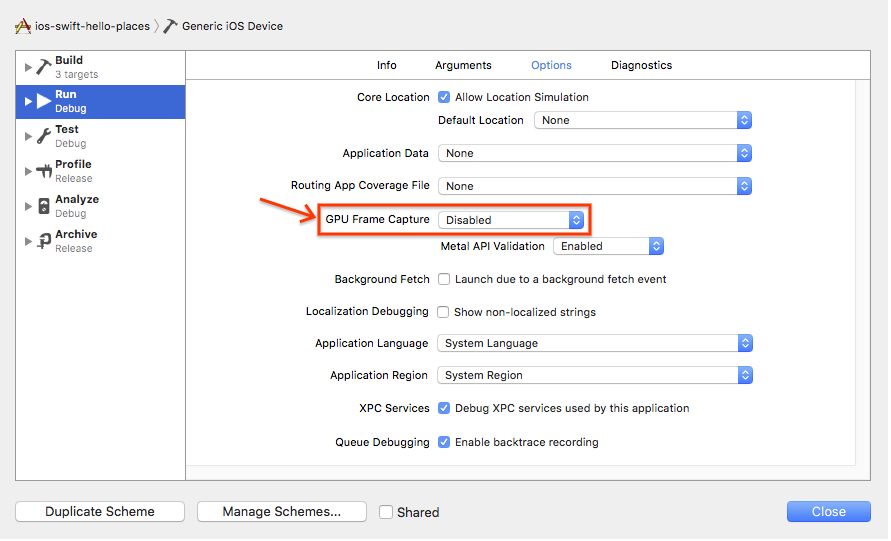
- I'm getting crashes when debugging with an iOS 8.x device. What should I do?
If you experience issues when debugging with devices running iOS 8.x, follow these steps to disable GPU frame capture in the XCode scheme you are running:
- In XCode, choose Product , Scheme , Manage Schemes .
- Select a scheme and choose Edit... .
- Set the GPU Frame Capture option to Disabled . Note that this option may not be present for all devices.
- What's the impact of rounded and wider screens on the Google Maps iOS SDK?
Beginning with the iPhone X , iPhones have a screen shape featuring rounded corners, a notch at the top for the device's sensor housing, and an indicator at the bottom of the screen for accessing the Home screen. As of iOS 11.0 SDK, Apple added the Safe Area API allowing developers to position elements in an area which is safe from being clipped by the new screen shape.
The Google Maps iOS SDK has many visual elements and controls, such as an indoor picker and the report a problem link. With version 2.4, these visual elements and controls could be clipped by the new screen shape. In landscape mode, the indoor floor picker may be clipped by either the notch or the home button indicator.
With the Google Maps iOS SDK 2.5 release these layout issues are fixed automatically. When your app is used on an iPhone X or later, the padding on GMSMapView and GMSPanoramaView are increased so that the visual elements aren't clipped.
By default, we will always include your padding. The Google Maps iOS SDK assumes that padding is intended to pad from within the safe area. If you design your interface with the assumption that everything is positioned within the safe area, this will work without any extra effort.
If you have designed an interface which doesn't work with our default adjustment, we have introduced a new property to GMSMapView, called paddingAdjustmentBehavior . Use GMSMapView to pick from one of three padding adjustments behaviors: 'Always' (default), 'Automatic', and 'Never'.
If GMSMapView is set to use the 'Always' padding behavior, it will always add the safe area insets to the padding. This setting lets you design your interface with the assumption that all placement is from the edges of the safe area. This is the default value.
If GMSMapView is set to use the 'Automatic' padding behavior, it will always choose the larger of padding or safe area inset. This setting lets you add padding from the screen edge while making sure that all elements stay within the safe area.
If GMSMapView is set to use the 'Never' padding behavior, it will never add the safe area insets to the padding. This is the behavior prior to the 2.5 release and may be useful if your padding already takes into consideration the safe area, or if our other behaviors don't act well with your interface. It is your responsibility to make sure that the Google logo and copyright notices are always visible, as specified in the Google Maps Platform Terms of Service .
In contrast, GMSPanoramaView doesn't have an optional padding property. This means that there is no padding to adjust and GMSPanoramaView will always apply any necessary padding so that all visual elements are within the safe area.
Google Maps SDK for Android
- How do I resolve the error:
9005 PLACES_API_RATE_LIMIT_EXCEEDED? - If you are seeing this error, you may be using a deprecated version of the Places SDK for Android. The Google Play services version of the Places SDK for Android has been turned off, and is no longer available. Update your app to use the latest version as soon as possible. See the migration guide for details.
- My app only shows blank grey tiles instead of a map. How can I resolve this?
A common reason that a blank grey tiles are shown instead of a map is authentication issues. You can follow the steps below to troubleshoot those issues by using adb logcat.
- Make sure you have adb installed. If not, you can follow the guide Android adb guide .
- Install the app that shows the problem on a device or an Android emulator. If you use Android emulator, make sure the emulator settings has Play Store included.
- In Android Studio terminal, run
adb logcat -e "Google Maps Android API". This will only print lines where the log message matches "Google Maps Android API" (Optionally, you can output the log to a text file by appending: > logcat.txt) - Reproduce the issue on your device and check for common errors such as:
- The wrong/unintended API Key is being referenced in Manifest.
- Billing isn't enabled on Project.
- The SDK isn't enabled on project APIs.
- The incorrect SHA-1 fingerprint is added to the API Key restrictions.
- The Google Play Service dependencies is not included in the
build.gradlefile.
- Is hardware acceleration required for the Google Maps SDK for Android?
- Yes,
hardwareAcceleratedmust be set totruein your app'sAndroidManifest.xmlfile in order to prevent issues with map loading.
For more information, see the Hardware acceleration page in the Android developer documentation.
URL signing
- Can I sign URLs using JavaScript?
We strongly recommend against signing URLs using JavaScript as this would expose your URL signing secret to end users. Therefore signatures should only be generated by server side components.
- Why am I receiving a HTTP 403 Forbidden response to my Maps API web service requests?
An HTTP 403 response indicates a permission issue, likely because the signature couldn't be verified for this request. This could be because:
- A signature has been specified but is incorrect for this request.
- The request specifies a Google Maps Platform Premium Plan an API key but does not specify a signature, and the service being called requires that requests made using an API key include a valid signature.
- A signature has been specified but the associated Google Maps Platform Premium Plan API key has not been specified.