
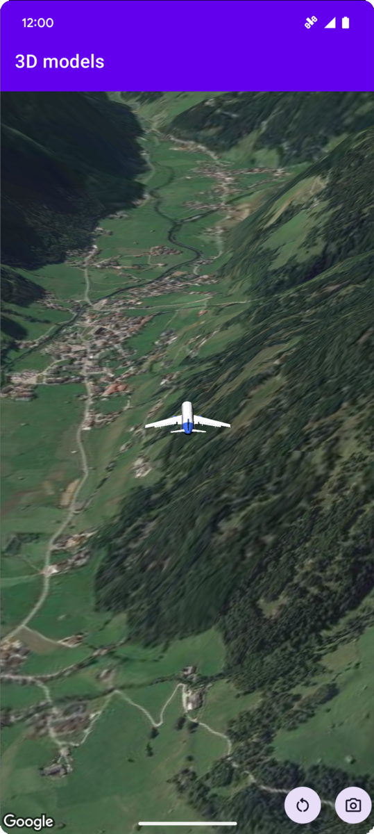
下列程式碼範例示範如何呼叫 addModel 方法,新增 3D 模型並在 3D 空間中放置模型。如要使用這個程式碼範例,請按照「設定」和「在應用程式中加入 3D 地圖」中的操作說明,在 Android Studio 專案中設定基本 3D 地圖。接著,將下列程式碼新增至 MainActivity.kt 檔案:
// Add imports and define constants
import com.google.android.gms.maps3d.model.latLngAltitude
val PLANE_URL = "https://storage.googleapis.com/gmp-maps-demos/p3d-map/assets/Airplane.glb"
val PLANE_SCALE = 0.05

// Add to the onMap3DViewReady method, after the googleMap3D object has been initialized
googleMap3D.setCamera(
   camera {
        center = latLngAltitude {
            latitude = 47.133971
            longitude = 11.333161
            altitude = 2200.0
        }
        heading = 221.0
        tilt = 65.0
        range = 1_200.0
    }
)

googleMap3D.addModel(
    modelOptions {
        id = "plane_model"
        position = latLngAltitude {
            latitude = 47.133971
            longitude = 11.333161
            altitude = 2200.0
        }
        altitudeMode = AltitudeMode.ABSOLUTE
        orientation = orientation {
            heading = 41.5
            tilt = -90.0
            roll = 0.0
        }
        url = PLANE_URL
        scale = vector3D {
            x = PLANE_SCALE
            y = PLANE_SCALE
            z = PLANE_SCALE
        }
    }
)
監聽 3D 模型點擊事件
如要監聽 3D 模型的點擊事件,請在模型物件上呼叫 setClickListener。以下範例說明如何在 3D 模型上設定點擊事件監聽器:
model.setClickListener {
    lifecycleScope.launch(Dispatchers.Main) {
        Toast.makeText(this@ModelsActivity, "Model clicked", Toast.LENGTH_SHORT).show()
    }
}
請注意,點擊處理常式不會在主 (或 UI) 執行緒上執行。如要變更 UI (例如顯示 Toast 訊息),請切換至 Main 執行緒。如果是 Kotlin,您可以使用 lifecycleScope.launch(Dispatchers.Main) 達成此效果。