Biro Sensus Amerika Serikat secara rutin merilis geodatabase bernama TIGER. Set data ini berisi blok sensus tahun 2020, yang kira-kira setara dengan blok kota. Ada lebih dari delapan juta fitur poligon yang mencakup Amerika Serikat, Distrik Columbia, Puerto Riko, dan Pulau …
Biro Sensus Amerika Serikat secara rutin merilis geodatabase bernama TIGER. Kumpulan data ini berisi kelompok blok sensus 2010, yang merupakan kelompok blok dalam wilayah sensus yang sama yang memiliki digit pertama yang sama dari nomor blok sensus empat digitnya. Hanya ada …
Biro Sensus Amerika Serikat secara rutin merilis geodatabase bernama TIGER. Dataset ini berisi kelompok blok sensus 2020, yang merupakan kelompok blok dalam wilayah sensus yang sama yang memiliki digit pertama yang sama dari nomor blok sensus empat digitnya. Hanya ada …
Biro Sensus Amerika Serikat secara rutin merilis geodatabase bernama TIGER. Set data ini berisi blok sensus tahun 2010, yang kira-kira setara dengan blok kota. Ada lebih dari 11 juta fitur poligon yang mencakup Amerika Serikat, Distrik Columbia, Puerto Riko, dan Pulau …
Dataset TIGER Biro Sensus Amerika Serikat berisi batas tahun 2016 untuk divisi hukum utama negara bagian AS. Di sebagian besar negara bagian, entitas ini disebut "county". Di Louisiana, divisi ini dikenal sebagai "parish". Alaska memiliki entitas pemerintah yang disebut "borough" yang mengisi fungsi pemerintah serupa …
Dataset TIGER Biro Sensus Amerika Serikat berisi batas wilayah hukum utama negara bagian AS tahun 2018. Di sebagian besar negara bagian, entitas ini disebut "county". Di Louisiana, divisi ini dikenal sebagai "parish". Alaska memiliki entitas pemerintah yang disebut "borough" yang mengisi fungsi pemerintah serupa …
Set data TIGER US Census Bureau ini berisi semua segmen jalan dari rilis tahun 2016, yang berisi lebih dari 19 juta fitur garis individual yang mencakup Amerika Serikat, Distrik Columbia, Puerto Riko, dan Wilayah Pulau. Setiap fitur mewakili geometri segmen jalan (…
Dataset TIGER Biro Sensus Amerika Serikat berisi batas wilayah tahun 2016 untuk divisi pemerintah utama Amerika Serikat. Selain lima puluh negara bagian, Biro Sensus memperlakukan District of Columbia, Puerto Riko, dan setiap wilayah kepulauan (Samoa Amerika, …
Set data TIGER Biro Sensus Amerika Serikat berisi batas wilayah untuk divisi pemerintahan utama Amerika Serikat tahun 2018. Selain lima puluh negara bagian, Biro Sensus memperlakukan District of Columbia, Puerto Riko, dan setiap wilayah kepulauan (Samoa Amerika, …
Biro Sensus Amerika Serikat secara rutin merilis geodatabase bernama TIGER. Set data ini berisi jalur sensus tahun 2020. Area wilayah sangat bervariasi, tetapi di area perkotaan kira-kira setara dengan lingkungan. Ada lebih dari 85.000 fitur poligon yang mencakup Amerika Serikat, Distrik …
Biro Sensus Amerika Serikat secara rutin merilis geodatabase bernama TIGER. Tabel ini berisi nilai Profil Demografis 1 sensus tahun 2010 yang dikelompokkan berdasarkan jalur sensus. Area wilayah sangat bervariasi, tetapi di area perkotaan kira-kira setara dengan lingkungan. Ada sekitar 74.000 fitur poligon …
Set data Litologi menyediakan kelas jenis umum bahan induk tanah di permukaan. Data ini tidak berasal dari DEM mana pun. Kumpulan Data Geomorphology (ERGo), Bentuk Lahan, dan Fisiografi yang Relevan secara Ekologis dari Conservation Science Partners (CSP) berisi data multi-skala yang mendetail tentang bentuk lahan dan fisiografi …
CHILI adalah pengganti efek insolasi dan naungan topografi pada evapotranspirasi yang diwakili dengan menghitung insolasi pada awal siang, ketinggian matahari setara dengan ekuinoks. Data ini didasarkan pada DEM NED 10 m USGS (tersedia di EE sebagai USGS/NED). The Conservation Science Partners (CSP) Ecologically …
Set data ALOS Landform menyediakan kelas bentang alam yang dibuat dengan menggabungkan set data Continuous Heat-Insolation Load Index (CHILI) dan multi-scale Topographic Position Index (mTPI). Data ini didasarkan pada DEM NED 10 m USGS (tersedia di EE sebagai USGS/NED). The Conservation Science Partners (CSP) Ecologically Relevant …
Kumpulan data Keberagaman Fisiografi menyediakan indeks keberagaman jenis fisiografi. Indeks ini dihitung menggunakan indeks keragaman Shannon pada beberapa skala (km): 115,8, 89,9, 35,5, 13,1, 5,6, 2,8, dan 1,2. Data ini didasarkan pada DEM NED 10 m USGS (tersedia di EE …
Keragaman topografi (D) adalah variabel pengganti yang merepresentasikan variasi kondisi suhu dan kelembapan yang tersedia bagi spesies sebagai habitat lokal. Hal ini menunjukkan logika bahwa berbagai macam ceruk topo-iklim harus mendukung keanekaragaman yang lebih tinggi (terutama tumbuhan) dan mendukung kelangsungan hidup spesies mengingat iklim …
mTPI membedakan bentuk punggung bukit dari bentuk lembah. mTPI dihitung menggunakan data elevasi untuk setiap lokasi yang dikurangi dengan elevasi rata-rata dalam suatu lingkungan. mTPI menggunakan jendela bergerak dengan radius (km): 115,8, 89,9, 35,5, 13,1, 5,6, 2,8, dan 1,2. Hal ini didasarkan pada … USGS
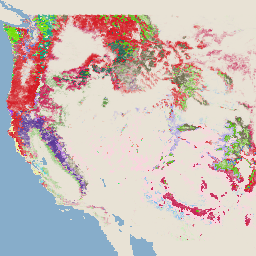
Set data Fisiografi merepresentasikan persimpangan spasial lapisan data bentuk lahan (tersedia di EE sebagai ERGo/1_0/US/landforms) dan litologi (tersedia di EE sebagai ERGo/1_0/US/lithology). Fitur ini menyediakan 247 kombinasi unik dari 270 kemungkinan kombinasi. Nilai untuk setiap jenis dibentuk dengan menggabungkan bentuk lahan dan …
Produk ini adalah bagian dari rangkaian data TreeMap. Data ini memberikan informasi spasial mendetail tentang karakteristik hutan, termasuk jumlah pohon hidup dan mati, biomassa, dan karbon di seluruh area hutan di Amerika Serikat pada tahun 2020. TreeMap v2020 berisi 22 band 30 x 30 m …
Produk ini adalah bagian dari rangkaian data TreeMap. Data ini memberikan informasi spasial terperinci tentang karakteristik hutan, termasuk jumlah pohon hidup dan mati, biomassa, dan karbon di seluruh kawasan hutan di Amerika Serikat pada tahun 2022. TreeMap v2022 berisi 22 band 30 x 30 m …
[[["Mudah dipahami","easyToUnderstand","thumb-up"],["Memecahkan masalah saya","solvedMyProblem","thumb-up"],["Lainnya","otherUp","thumb-up"]],[["Informasi yang saya butuhkan tidak ada","missingTheInformationINeed","thumb-down"],["Terlalu rumit/langkahnya terlalu banyak","tooComplicatedTooManySteps","thumb-down"],["Sudah usang","outOfDate","thumb-down"],["Masalah terjemahan","translationIssue","thumb-down"],["Masalah kode / contoh","samplesCodeIssue","thumb-down"],["Lainnya","otherDown","thumb-down"]],[],[],[]]