Desde 2011, la Oficina de Administración de Tierras (BLM) recopila información de campo para fundamentar el estado de la tierra a través de su estrategia de Evaluación, Inventario y Monitoreo (AIM). Hasta la fecha, se recopilaron más de 6,000 parcelas de campo de AIM terrestres en tierras de la BLM. El archivo de datos de AIM de la BLM es …
El conjunto de datos de FLDAS (McNally et al., 2017) se diseñó para ayudar con las evaluaciones de seguridad alimentaria en entornos de países en desarrollo con pocos datos. Incluye información sobre muchas variables relacionadas con el clima, como el contenido de humedad, la humedad, la evapotranspiración, la temperatura promedio del suelo, la tasa de precipitación total, etcétera. Existen varios conjuntos de datos diferentes de FLDAS. …
El Sistema Global de Asimilación de Datos Terrestres de la NASA, versión 2 (GLDAS-2), tiene tres componentes: GLDAS-2.0, GLDAS-2.1 y GLDAS-2.2. GLDAS-2.0 se basa por completo en los datos de entrada de forzamiento meteorológico de Princeton y proporciona una serie temporal coherente desde 1948 hasta 2014. GLDAS-2.1 se fuerza con una combinación de modelos…
El Sistema Global de Asimilación de Datos Terrestres de la NASA, versión 2 (GLDAS-2), tiene tres componentes: GLDAS-2.0, GLDAS-2.1 y GLDAS-2.2. GLDAS-2.0 se basa por completo en los datos de entrada de forzamiento meteorológico de Princeton y proporciona una serie temporal coherente desde 1948 hasta 2014. GLDAS-2.1 se fuerza con una combinación de modelos…
M2T1NXLND (o tavg1_2d_lnd_Nx) es una recopilación de datos promediados por hora en el análisis retrospectivo de la era moderna para la investigación y las aplicaciones, versión 2 (MERRA-2). Esta colección consta de diagnósticos de la superficie terrestre, como el flujo de base, la escorrentía, la humedad del suelo superficial, la humedad del suelo de la zona radicular, el agua en la capa superficial, el agua en…
El Sistema de Asimilación de Datos Terrestres (LDAS) combina varias fuentes de observaciones (como datos de pluviómetros, datos satelitales y mediciones de precipitación por radar) para producir estimaciones de las propiedades climatológicas en la superficie terrestre o cerca de ella. Este conjunto de datos es el archivo de forzamiento principal (predeterminado) (archivo A) para la fase…
Contenido de arcilla en % (kg / kg) a 6 profundidades estándar (0, 10, 30, 60, 100 y 200 cm) con una resolución de 250 m. Se basa en predicciones de aprendizaje automático a partir de una recopilación global de muestras y perfiles de suelo. Aquí se describen en detalle los pasos del procesamiento. La Antártida es…
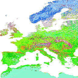
Grandes grupos de suelo del USDA predichos a 250 m (probabilidades). Distribución de los grandes grupos de suelos del USDA según las predicciones de aprendizaje automático de la recopilación global de perfiles de suelos. Para obtener más información sobre los grandes grupos de suelo, consulta la guía ilustrada de la taxonomía del suelo del NRCS…
Contenido de arena en % (kg / kg) a 6 profundidades estándar (0, 10, 30, 60, 100 y 200 cm) con una resolución de 250 m. Se basa en predicciones de aprendizaje automático a partir de una compilación global de perfiles y muestras de suelo. Aquí se describen en detalle los pasos del procesamiento. La Antártida es…
Densidad aparente del suelo (tierra fina) 10 x kg / m³ a 6 profundidades estándar (0, 10, 30, 60, 100 y 200 cm) con una resolución de 250 m. Aquí se describen en detalle los pasos del procesamiento. No se incluye la Antártida. Para acceder a mapas y visualizarlos fuera de Earth, haz lo siguiente:
Contenido de carbono orgánico del suelo en x 5 g / kg a 6 profundidades estándar (0, 10, 30, 60, 100 y 200 cm) a una resolución de 250 m. Se predice a partir de una recopilación global de puntos de suelo. Aquí se describen en detalle los pasos del procesamiento. No se incluye la Antártida. …
Clases de textura del suelo (sistema del USDA) para 6 profundidades del suelo (0, 10, 30, 60, 100 y 200 cm) a 250 m. Se derivan de las fracciones de textura del suelo predichas con el paquete soiltexture en R. Aquí se describen en detalle los pasos del procesamiento. No se incluye la Antártida. Para acceder a…
Contenido de agua del suelo (porcentaje volumétrico) para succiones de 33 kPa y 1,500 kPa predichas a 6 profundidades estándar (0, 10, 30, 60, 100 y 200 cm) con una resolución de 250 m. Los puntos de entrenamiento se basan en una recopilación global de perfiles de suelo: USDA NCSS AfSPDB ISRIC WISE EGRPR SPADE…
pH del suelo en H2O a 6 profundidades estándar (0, 10, 30, 60, 100 y 200 cm) con una resolución de 250 m. Los pasos del procesamiento se describen en detalle aquí. No se incluye la Antártida. Usa esta página para acceder a mapas y visualizarlos fuera de Earth Engine. Si usted …
Probabilidades de grandes grupos de suelo del USDA predichas a 250 m. Distribución de los grandes grupos de suelos del USDA según las predicciones de aprendizaje automático de la recopilación global de perfiles de suelos. Para obtener más información sobre los grandes grupos de suelo, consulta la Illustrated Guide to Soil Taxonomy - NRCS - …
El Sistema Global de Asimilación de Datos Terrestres de la NASA, versión 2 (GLDAS-2), tiene tres componentes: GLDAS-2.0, GLDAS-2.1 y GLDAS-2.2. GLDAS-2.0 se basa por completo en los datos de entrada de forzamiento meteorológico de Princeton y proporciona una serie temporal coherente desde 1948 hasta 2014. GLDAS-2.1 se fuerza con una combinación de modelos…
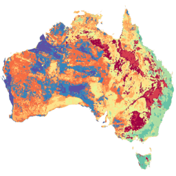
La cuadrícula de suelo y paisaje de Australia (SLGA) es un conjunto de datos integral de atributos del suelo en toda Australia con una resolución de 3 segundos de arco (píxeles de ~90 m). Las superficies son los resultados del modelado que describen la distribución espacial de los atributos del suelo a partir de los datos existentes del suelo y los datos ambientales…
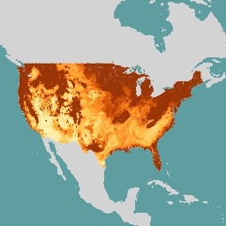
SOLUS (Soil Landscapes of the United States) es un producto de mapa nacional desarrollado por el National Cooperative Soil Survey que se enfoca en proporcionar un conjunto coherente de mapas de propiedades del suelo continuos espacialmente para respaldar investigaciones del suelo a gran escala y decisiones sobre el uso de la tierra. Los mapas de SOLUS…
Los datos a partir del 2023-12-04 están disponibles en la colección NASA/SMAP/SPL3SMP_E/006. Este producto de humedad del suelo de nivel 3 (L3) proporciona un compuesto diario de las condiciones de la superficie terrestre global recuperadas por el radiómetro de banda L del Soil Moisture Active Passive (SMAP). Los datos diarios que se muestran aquí se recopilaron de la lista descendente (local…
Los datos a priori del 2023-12-04 están disponibles en la colección anterior NASA/SMAP/SPL3SMP_E/005. Con el tiempo, se volverán a procesar y se agregarán a esta colección. Este producto de humedad del suelo de nivel 3 (L3) proporciona un compuesto diario de las condiciones globales de la superficie terrestre recuperadas por el sensor activo y pasivo de humedad del suelo (SMAP) de banda L…
El producto de humedad del suelo de nivel 4 (L4) de SMAP incluye la humedad del suelo superficial (promedio vertical de 0 a 5 cm), la humedad del suelo de la zona radicular (promedio vertical de 0 a 100 cm) y productos de investigación adicionales (no validados), incluidas las variables de forzamiento meteorológico superficial, la temperatura del suelo, la evapotranspiración y la radiación neta. Este conjunto de datos, conocido formalmente como…
Contenido de agua volumétrico a una succión de 10 kPa, 33 kPa y 1, 500 kPa en 10^-3 cm³/cm³ (0.1 v% o 1 mm/m) a 6 profundidades estándar (0-5 cm, 5-15 cm, 15-30 cm, 30-60 cm, 60-100 cm, 100-200 cm). Las predicciones se obtuvieron con un enfoque de creación de mapas digitales del suelo basado en el bosque aleatorio de cuantiles, que se basa en un conjunto de datos global…
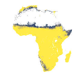
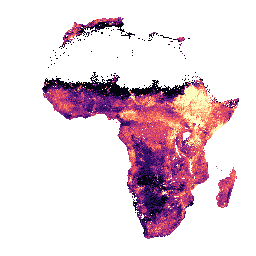
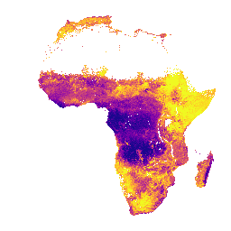
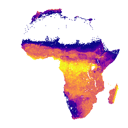
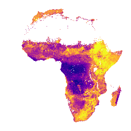
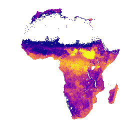
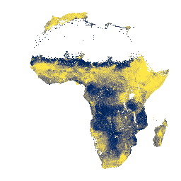
Densidad aparente, fracción <2 mm en profundidades del suelo de 0 a 20 cm y de 20 a 50 cm, media y desviación estándar predichas. Los valores de píxeles se deben transformar de nuevo con x/100. En las áreas de selva densa (generalmente en África central), la precisión del modelo es baja y, por lo tanto, se producen artefactos como bandas (rayas)…
Contenido de arcilla en profundidades del suelo de 0 a 20 cm y de 20 a 50 cm, desviación estándar y media predichas. En las áreas de selva densa (generalmente en África central), la precisión del modelo es baja y, por lo tanto, se pueden observar artefactos, como bandas (rayas). Innovative … realizó las predicciones de las propiedades del suelo.
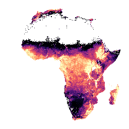
Profundidad hasta la roca madre a una profundidad de 0 a 200 cm, media y desviación estándar previstas. Debido a la posible máscara de tierra cultivable que se usó para generar los datos, se enmascararon muchas áreas de roca expuesta (en las que la profundidad hasta la roca madre sería de 0 cm) y, por lo tanto, aparecen…
Media y desviación estándar predichas de la capacidad de intercambio catiónico efectiva en profundidades de suelo de 0 a 20 cm y de 20 a 50 cm. Los valores de píxeles se deben transformar de nuevo con exp(x/10)-1. En las áreas de selva densa (generalmente en África central), la precisión del modelo es baja y, por lo tanto, se producen artefactos como bandas (rayas)…
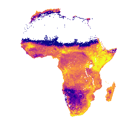
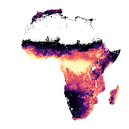
Calcio extraíble en profundidades del suelo de 0 a 20 cm y de 20 a 50 cm, media y desviación estándar previstas. Los valores de píxeles se deben transformar de nuevo con exp(x/10)-1. En las áreas de selva densa (generalmente en África central), la precisión del modelo es baja y, por lo tanto, es posible que aparezcan artefactos, como bandas (rayas)…
Hierro extraíble en profundidades del suelo de 0 a 20 cm y de 20 a 50 cm, media y desviación estándar previstas. Los valores de píxeles se deben transformar de nuevo con exp(x/10)-1. En las áreas de selva densa (generalmente en África central), la precisión del modelo es baja y, por lo tanto, es posible que aparezcan artefactos, como bandas (rayas)…
Magnesio extraíble en profundidades del suelo de 0 a 20 cm y de 20 a 50 cm, media y desviación estándar predichas. Los valores de píxeles se deben transformar de nuevo con exp(x/10)-1. En las áreas de selva densa (generalmente en África central), la precisión del modelo es baja y, por lo tanto, es posible que aparezcan artefactos, como bandas (rayas)…
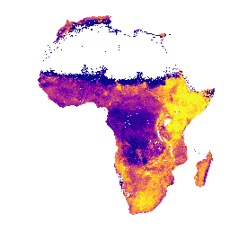
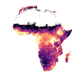
Fósforo extraíble en profundidades del suelo de 0 a 20 cm y de 20 a 50 cm, media y desviación estándar previstas. Los valores de píxeles se deben transformar de nuevo con exp(x/10)-1. En las áreas de selva densa (generalmente en África central), la precisión del modelo es baja y, por lo tanto, es posible que aparezcan artefactos, como bandas (rayas)…
Potasio extraíble en profundidades del suelo de 0 a 20 cm y de 20 a 50 cm, media y desviación estándar predichas. Los valores de píxeles se deben transformar de nuevo con exp(x/10)-1. En las áreas de selva densa (generalmente en África central), la precisión del modelo es baja y, por lo tanto, es posible que aparezcan artefactos, como bandas (rayas)…
Azufre extraíble en profundidades del suelo de 0 a 20 cm y de 20 a 50 cm, media y desviación estándar previstas. Los valores de píxeles se deben transformar de nuevo con exp(x/10)-1. En las áreas de selva densa (generalmente en África central), la precisión del modelo es baja y, por lo tanto, es posible que aparezcan artefactos, como bandas (rayas)…
Zinc extraíble en profundidades del suelo de 0 a 20 cm y de 20 a 50 cm, media y desviación estándar previstas. Los valores de píxeles se deben transformar de nuevo con exp(x/10)-1. En las áreas de selva densa (generalmente en África central), la precisión del modelo es baja y, por lo tanto, es posible que aparezcan artefactos, como bandas (rayas)…
Clasificación de la capacidad de fertilidad del suelo derivada de las propiedades químicas y físicas del suelo y la pendiente. Para obtener más información sobre esta capa, visita esta página. Las clases para la banda "fcc" se aplican a los valores de píxeles que se deben transformar de nuevo con x módulo 3000. En áreas de selva densa…
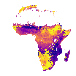
Carbono orgánico en profundidades del suelo de 0 a 20 cm y de 20 a 50 cm, media y desviación estándar previstas. Los valores de píxeles se deben transformar de nuevo con exp(x/10)-1. En las áreas de selva densa (generalmente en África central), la precisión del modelo es baja y, por lo tanto, es posible que aparezcan artefactos, como bandas (rayas)…
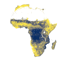
Contenido de arena en profundidades del suelo de 0 a 20 cm y de 20 a 50 cm, desviación estándar y media predichas. En las áreas de selva densa (generalmente en África central), la precisión del modelo es baja y, por lo tanto, se pueden observar artefactos, como bandas (rayas). Innovative … realizó las predicciones de las propiedades del suelo.
Contenido de limo en profundidades del suelo de 0 a 20 cm y de 20 a 50 cm, media y desviación estándar predichas. Los valores de píxeles se deben transformar de nuevo con exp(x/10)-1. En las áreas de selva densa (generalmente en África central), la precisión del modelo es baja y, por lo tanto, es posible que aparezcan artefactos, como bandas (rayas)…
Contenido de piedras en profundidades del suelo de 0 a 20 cm y de 20 a 50 cm, media y desviación estándar predichas. Los valores de píxeles se deben transformar de nuevo con exp(x/10)-1. En las áreas de selva densa (generalmente en África central), la precisión del modelo es baja y, por lo tanto, es posible que aparezcan artefactos, como bandas (rayas)…
Carbono total en profundidades del suelo de 0 a 20 cm y de 20 a 50 cm, media y desviación estándar previstas. Los valores de píxeles se deben transformar de nuevo con exp(x/10)-1. En las áreas de selva densa (generalmente en África central), la precisión del modelo es baja y, por lo tanto, es posible que aparezcan artefactos, como bandas (rayas)…
Nitrógeno total en profundidades del suelo de 0 a 20 cm y de 20 a 50 cm, media y desviación estándar previstas. Los valores de píxeles se deben transformar de nuevo con exp(x/100)-1. En las áreas de selva densa (generalmente en África central), la precisión del modelo es baja y, por lo tanto, es posible que aparezcan artefactos, como bandas (rayas)…
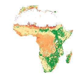
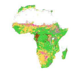
Clase de textura del USDA en profundidades del suelo de 0 a 20 cm y de 20 a 50 cm. En las áreas de selva densa (generalmente en África central), la precisión del modelo es baja y, por lo tanto, se pueden observar artefactos, como bandas (rayas). Las predicciones de las propiedades del suelo fueron realizadas por Innovative Solutions for Decision…
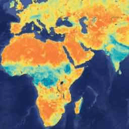
Aluminio extraíble en profundidades del suelo de 0 a 20 cm y de 20 a 50 cm, media y desviación estándar predichas. Los valores de píxeles se deben transformar de nuevo con exp(x/10)-1. Las predicciones de las propiedades del suelo se realizaron con un tamaño de píxel de 30 m a través de Innovative Solutions for Decision Agriculture Ltd. (iSDA) con aprendizaje automático combinado…
pH a profundidades del suelo de 0 a 20 cm y de 20 a 50 cm, media y desviación estándar predichas. Los valores de píxeles se deben transformar de nuevo con x/10. En las áreas de selva densa (generalmente en África central), la precisión del modelo es baja y, por lo tanto, se pueden observar artefactos, como bandas (rayas). …
[[["Fácil de comprender","easyToUnderstand","thumb-up"],["Resolvió mi problema","solvedMyProblem","thumb-up"],["Otro","otherUp","thumb-up"]],[["Falta la información que necesito","missingTheInformationINeed","thumb-down"],["Muy complicado o demasiados pasos","tooComplicatedTooManySteps","thumb-down"],["Desactualizado","outOfDate","thumb-down"],["Problema de traducción","translationIssue","thumb-down"],["Problema con las muestras o los códigos","samplesCodeIssue","thumb-down"],["Otro","otherDown","thumb-down"]],[],[],[]]