Page Summary
-
The Global Inland Water dataset identifies inland surface water bodies like lakes, rivers, and reservoirs.
-
The Global Forest Cover Change dataset provides 30-m pixel estimates of horizontal ground covered by woody vegetation over 5 meters tall.
-
GLCF: Landsat Global Inland Water
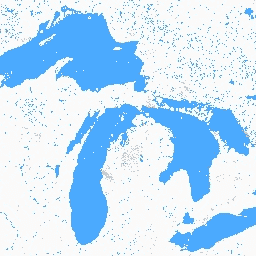
The Global Inland Water dataset shows inland surface water bodies, including fresh and saline lakes, rivers, and reservoirs. From the GLS 2000 epoch, 3,650,723 km2 of inland water were identified, around three quarters of which were in North America and Asia. Boreal forests and tundra … glcf landsat-derived nasa surface-ground-water umd water -
Global Forest Cover Change (GFCC) Tree Cover Multi-Year Global 30m
The Landsat Vegetation Continuous Fields (VCF) tree cover layers contain estimates of the percentage of horizontal ground in each 30-m pixel covered by woody vegetation greater than 5 meters in height. The dataset is available for four epochs centered on the years 2000, 2005, 2010 … forest forest-biomass glcf landsat-derived nasa umd