Page Summary
-
Geoscience Australia provides Earth observation services, expert advice, and information to support government priorities and promote the use of satellite imagery.
-
The organization aims to advance remote sensing science, ensure access to data, and coordinate national imagery for disasters and emergencies.
-
Geoscience Australia offers datasets such as the National Intertidal Digital Elevation Model and DEA Land Cover, providing detailed information about Australia's land and water.
-
Statistical tools like the DEA Geometric Median and Median Absolute Deviation for various Landsat satellites are available to analyze changes over time using Digital Earth Australia data.
Geoscience Australia provides Earth observation services, expert advice, and information for decision makers. Program objectives are:
- ensure continuity of access to remotely sensed information in support of government priorities.
- promote use and value of satellite imagery within government, industry and the wider community.
- advance remote sensing science through extracting value and use of EOS to its full potential
- provide data stewardship to ensure access to data, and
- provide national imagery coordination for disasters and emergencies.
-
National Intertidal Digital Elevation Model 25m 1.0.0 [deprecated]
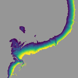
The National Intertidal Digital Elevation Model (NIDEM; Bishop-Taylor et al. 2018, 2019) is a continental-scale elevation dataset for Australia's exposed intertidal zone. NIDEM provides the first three-dimensional representation of Australia's intertidal sandy beaches and shores, tidal flats and rocky shores and reefs at 25 m … australia dem ga geoscience-aus-cat landsat-derived publisher-dataset -
DEA Geometric Median and Median Absolute Deviation - Landsat 5 3.1.0 [deprecated]
This product provides statistical tools to exploit the time series of Landsat 5 data available in Digital Earth Australia, providing annual images of general conditions and how much an area changes for a given year. The geomedian part of the product provides an "average" cloud-free … australia ga geoscience-aus-cat landsat-derived publisher-dataset -
DEA Geometric Median and Median Absolute Deviation - Landsat 7 3.1.0 [deprecated]
This product provides statistical tools to exploit the time series of Landsat 7 data available in Digital Earth Australia, providing annual images of general conditions and how much an area changes for a given year. The geomedian part of the product provides an "average" cloud-free … australia ga geoscience-aus-cat landsat-derived publisher-dataset -
DEA Geometric Median and Median Absolute Deviation - Landsat 8 and 9 v4.0.0 [deprecated]

This product provides statistical tools to exploit the time series of Landsat 8 and 9 data available in Digital Earth Australia, providing annual images of general conditions and how much an area changes for a given year. For calendar years 2022 onwards, Landsat 8 and … australia ga geoscience-aus-cat landsat-derived publisher-dataset -
DEA Land Cover 1.0.0 [deprecated]
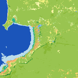
Digital Earth Australia (DEA) Land Cover provides annual land cover classifications for Australia using the Food and Agriculture Organisation Land Cover Classification System taxonomy Version 2 (Di Gregorio and Jansen, 1998; 2005). DEA Land Cover translates over 30 years of satellite imagery into evidence of … australia ga geoscience-aus-cat landcover landsat-derived publisher-dataset -
DEA Water Observations Statistics 3.1.6 [deprecated]

Digital Earth Australia (DEA) Water Observations uses an algorithm to classify each pixel from Landsat satellite imagery as 'wet', 'dry', or 'invalid'. Water Observations Statistics provides information on how many times each year the Landsat satellites were able to clearly see an area, how many … australia ga geoscience-aus-cat landsat-derived publisher-dataset water