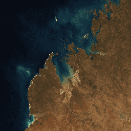
This product provides statistical tools to exploit the time series of Landsat 7 data available in Digital Earth Australia, providing annual images of general conditions and how much an area changes for a given year.
The geomedian part of the product provides an "average" cloud-free image over the given year. The geomedian image is calculated with a multi-dimensional median, using all the spectral measurements from the satellite imagery at the same time in order to maintain the relationships among the measurements.
The median absolute deviation part of the product uses three measures of variance, each of which provides a "second order" high dimensional statistical composite for the given year. The three variance measures show how much an area varies from the "average" in terms of "distance" based on factors such as brightness and spectra:
Euclidean distance (EMAD)
Cosine (spectral) distance (SMAD)
Bray Curtis dissimilarity (BCMAD)
Together, they provide information on variance in the landscape over the given year and are useful for change detection applications.
The Median Absolute Deviation using Bray Curtis dissimilarity (BCMAD). BCMAD is more sensitive to the distribution of the observation values through time.
count
0*
400*
The number of the available pixels used for calculation per calendar year.
Roberts, D., Mueller, N., & Mcintyre, A. (2017). High-dimensional pixel composites from earth observation time series. IEEE Transactions on Geoscience and Remote Sensing, 55(11), 6254-6264.
doi:10.1109/TGRS.2017.2723896.
Roberts, D., Dunn, B., & Mueller, N. (2018). Open data cube products using high-dimensional statistics of time series. IGARSS 2018 - 2018 IEEE International Geoscience and Remote Sensing Symposium, 8647-8650.
doi:10.1109/IGARSS.2018.8518312.
This product provides statistical tools to exploit the time series of Landsat 7 data available in Digital Earth Australia, providing annual images of general conditions and how much an area changes for a given year. The geomedian part of the product provides an "average" cloud-free image over the given year. …
[[["Easy to understand","easyToUnderstand","thumb-up"],["Solved my problem","solvedMyProblem","thumb-up"],["Other","otherUp","thumb-up"]],[["Missing the information I need","missingTheInformationINeed","thumb-down"],["Too complicated / too many steps","tooComplicatedTooManySteps","thumb-down"],["Out of date","outOfDate","thumb-down"],["Samples / code issue","samplesCodeIssue","thumb-down"],["Other","otherDown","thumb-down"]],[],[[["\u003cp\u003eThis dataset provides annual images of general conditions and how much an area in Australia changes for a given year using Landsat 7 data.\u003c/p\u003e\n"],["\u003cp\u003eThe geomedian image provides an "average" cloud-free image over the year, while the median absolute deviation shows variance from the average.\u003c/p\u003e\n"],["\u003cp\u003eThree measures of variance (EMAD, SMAD, BCMAD) are included, each sensitive to different types of changes.\u003c/p\u003e\n"],["\u003cp\u003eThe dataset is available from 2000-2021 with a 25-meter resolution and is part of the Digital Earth Australia Program.\u003c/p\u003e\n"],["\u003cp\u003eThis dataset is part of a Publisher Catalog managed by Geoscience Australia and is available under the CC BY 4.0 license.\u003c/p\u003e\n"]]],["This Landsat 7 dataset, part of the Geoscience Australia Catalog, offers annual cloud-free images reflecting general conditions and changes in areas from 2000 to 2021. It uses geomedian for \"average\" images and median absolute deviation (EMAD, SMAD, BCMAD) to measure variance. Key actions involve accessing the dataset via an Earth Engine snippet, filtering by bounds and date, and visualizing with selected bands. This dataset will be removed March 1, 2025.\n"],null,["# DEA Geometric Median and Median Absolute Deviation - Landsat 7 3.1.0 [deprecated]\n\n**Caution:** This dataset was removed on March 01, 2025. [Learn more.](https://developers.google.com/earth-engine/datasets/reference/removed_datasets#geoscience_australia_publisher_catalog) \ninfo\n\n\nThis dataset is part of a Publisher Catalog, and not managed by Google Earth Engine.\n\nContact [Geoscience Australia](https://www.ga.gov.au/contact-us)\n\nfor bugs or [view more datasets](https://developers.google.com/earth-engine/datasets/publisher/geoscience-aus-cat)\nfrom the Geoscience Australia Catalog. [Learn more about Publisher datasets](/earth-engine/datasets/publisher). \n[](https://www.ga.gov.au/) \n\nCatalog Owner\n: Geoscience Australia\n\nDataset Availability\n: 2000-01-01T00:00:00Z--2021-01-01T00:00:00Z\n\nDataset Provider\n:\n\n\n [Geoscience Australia](https://cmi.ga.gov.au/data-products/dea/645/dea-geometric-median-and-median-absolute-deviation-landsat#basics)\n\n\n [NGIS](https://ngis.com.au/)\n\nContact\n: [Geoscience Australia](https://www.ga.gov.au/contact-us)\n\nTags\n:\n[australia](/earth-engine/datasets/tags/australia) [ga](/earth-engine/datasets/tags/ga) [geoscience-aus-cat](/earth-engine/datasets/tags/geoscience-aus-cat) [landsat-derived](/earth-engine/datasets/tags/landsat-derived) [publisher-dataset](/earth-engine/datasets/tags/publisher-dataset) \n\n#### Description\n\nThis product provides statistical tools to exploit the time series of Landsat 7 data available in Digital Earth Australia, providing annual images of general conditions and how much an area changes for a given year.\n\nThe geomedian part of the product provides an \"average\" cloud-free image over the given year. The geomedian image is calculated with a multi-dimensional median, using all the spectral measurements from the satellite imagery at the same time in order to maintain the relationships among the measurements.\n\nThe median absolute deviation part of the product uses three measures of variance, each of which provides a \"second order\" high dimensional statistical composite for the given year. The three variance measures show how much an area varies from the \"average\" in terms of \"distance\" based on factors such as brightness and spectra:\n\n- Euclidean distance (EMAD)\n- Cosine (spectral) distance (SMAD)\n- Bray Curtis dissimilarity (BCMAD)\n\nTogether, they provide information on variance in the landscape over the given year and are useful for change detection applications.\n\nFor more information, please see the [DEA Geometric Median and Median Absolute Deviation Landsat](https://cmi.ga.gov.au/data-products/dea/645/dea-geometric-median-and-median-absolute-deviation-landsat)\n\nThis product is part of the [Digital Earth Australia Program](https://www.dea.ga.gov.au/)\n\n### Bands\n\n\n**Pixel Size**\n\n25 meters\n\n**Bands**\n\n| Name | Min | Max | Wavelength | Description |\n|-------------------------------------------------------|-----|---------|----------------|------------------------------------------------------------------------------------------------------------------------------------------------------------|\n| `blue` | 0\\* | 10000\\* | 0.450-0.515 μm | Band blue surface reflectance geometric median. |\n| `green` | 0\\* | 10000\\* | 0.525-0.605 μm | Band green surface reflectance geometric median. |\n| `red` | 0\\* | 10000\\* | 0.630-0.690 μm | Band red surface reflectance geometric median. |\n| `near_infrared` | 0\\* | 10000\\* | 0.775-0.900 μm | Band near infrared surface reflectance geometric median. |\n| `shortwave_infrared_1` | 0\\* | 10000\\* | 1.550-1.750 μm | Band shortwave infrared 1 surface reflectance geometric median. |\n| `shortwave_infrared_2` | 0\\* | 10000\\* | 2.080-2.350 μm | Band shortwave infrared 2 surface reflectance geometric median. |\n| `Euclidean_distance_median_absolute_deviation` | 0\\* | 10000\\* | | The Median Absolute Deviation using Euclidean distance (EMAD). EMAD is more sensitive to changes in target brightness. |\n| `spectral_distance_median_absolute_deviation` | 0\\* | 10000\\* | | The Median Absolute Deviation using Cosine (spectral) distance (SMAD). SMAD is more sensitive to change in target spectral response. |\n| `Bray_Curtis_dissimilarity_median_absolute_deviation` | 0\\* | 10000\\* | | The Median Absolute Deviation using Bray Curtis dissimilarity (BCMAD). BCMAD is more sensitive to the distribution of the observation values through time. |\n| `count` | 0\\* | 400\\* | | The number of the available pixels used for calculation per calendar year. |\n\n\\* estimated min or max value\n\n### Terms of Use\n\n**Terms of Use**\n\n[CC-BY-4.0](https://spdx.org/licenses/CC-BY-4.0.html)\n\n### Citations\n\nCitations:\n\n- Roberts, D., Mueller, N., \\& Mcintyre, A. (2017). High-dimensional pixel composites from earth observation time series. IEEE Transactions on Geoscience and Remote Sensing, 55(11), 6254-6264.\n [doi:10.1109/TGRS.2017.2723896](https://doi.org/10.1109/TGRS.2017.2723896).\n Roberts, D., Dunn, B., \\& Mueller, N. (2018). Open data cube products using high-dimensional statistics of time series. IGARSS 2018 - 2018 IEEE International Geoscience and Remote Sensing Symposium, 8647-8650.\n [doi:10.1109/IGARSS.2018.8518312](https://doi.org/10.1109/IGARSS.2018.8518312).\n\n### DOIs\n\n- \u003chttps://doi.org/10.1109/IGARSS.2018.8518312\u003e\n- \u003chttps://doi.org/10.1109/TGRS.2017.2723896\u003e\n**Important:** Earth Engine is a platform for petabyte-scale scientific analysis and visualization of geospatial datasets, both for public benefit and for business and government users. Earth Engine is free to use for research, education, and nonprofit use. To get started, please [register for Earth Engine access.](https://console.cloud.google.com/earth-engine) \n[DEA Geometric Median and Median Absolute Deviation - Landsat 7 3.1.0 \\[deprecated\\]](/earth-engine/datasets/catalog/projects_geoscience-aus-cat_assets_ga_ls7e_nbart_gm_cyear_3) \nThis product provides statistical tools to exploit the time series of Landsat 7 data available in Digital Earth Australia, providing annual images of general conditions and how much an area changes for a given year. The geomedian part of the product provides an \"average\" cloud-free image over the given year. ... \nprojects/geoscience-aus-cat/assets/ga_ls7e_nbart_gm_cyear_3, australia,ga,geoscience-aus-cat,landsat-derived,publisher-dataset \n2000-01-01T00:00:00Z/2021-01-01T00:00:00Z \n-44.41 108.81 -9.13 157.82 \nGoogle Earth Engine \nhttps://developers.google.com/earth-engine/datasets\n\n- [https://doi.org/10.1109/TGRS.2017.2723896](https://doi.org/https://cmi.ga.gov.au/data-products/dea/645/dea-geometric-median-and-median-absolute-deviation-landsat#basics)\n- [https://doi.org/10.1109/TGRS.2017.2723896](https://doi.org/https://ngis.com.au/)\n- [https://doi.org/10.1109/TGRS.2017.2723896](https://doi.org/https://developers.google.com/earth-engine/datasets/catalog/projects_geoscience-aus-cat_assets_ga_ls7e_nbart_gm_cyear_3)"]]