- Disponibilité de l'ensemble de données
- 2012-01-01T00:00:00Z–2019-04-23T00:00:00Z
- Producteur de l'ensemble de données
- World Resources Institute / Global Forest Watch
- Tags
Description
REMARQUE du WRI : Le WRI a décidé de ne plus mettre à jour les alertes FORMA. L'objectif était de simplifier l'expérience utilisateur de Global Forest Watch et de réduire la redondance. Nous avons constaté que Terra-i et GLAD étaient plus fréquemment utilisés. De plus, en utilisant GLAD comme norme, ils ont constaté que Terra-i était plus performant que FORMA à l'échelle mondiale.
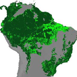
Les alertes FORMA sont détectées à l'aide d'une combinaison de deux produits MODIS : NDVI (Normalized Difference Vegetation Index) et FIRMS (Fires Information for Resource Management System). Les mises à jour de l'indice NDVI sont traitées tous les 16 jours, tandis que celles des incendies le sont quotidiennement. Les modèles sont développés individuellement pour chaque éco-groupe afin de relier les deux entrées à la zone de déforestation, en utilisant les données annuelles de perte de couverture forestière de Hansen pour entraîner le modèle. Le seuil minimal pour qu'une alerte soit déclenchée est de 25 % des pixels effacés. Toutefois, les seuils varient selon l'écogroupe afin de minimiser les faux positifs. Voici un script d'exemple pour une brève présentation des ensembles de données FORMA.
Les images de cette ImageCollection contiennent les données FORMA brutes calculées après la disponibilité de nouvelles données MODIS NDVI, soit environ tous les 16 jours.
L'image contient quatre bandes. Les bandes "delta", "near_term_delta" et "clearing" indiquent toutes un pourcentage de compensation (de 0 à 100) pour différentes périodes d'accumulation. La précision est une mesure de la confiance dans ces prédictions (0 = très peu de confiance, 100 = confiance élevée).
Bandes
Bandes de fréquences
Taille des pixels : 250 mètres (toutes les bandes)
| Nom | Unités | Min | Max | Taille des pixels | Description |
|---|---|---|---|---|---|
delta |
% | 0 | 100 | 250 mètres | Pourcentage de paiements au cours des 96 derniers jours |
near_term_delta |
% | 0 | 100 | 250 mètres | Pourcentage de compensation au cours des 32 derniers jours |
accuracy |
% | 0 | 100 | 250 mètres | Confiance dans les prédictions |
clearing |
% | 0 | 100 | 250 mètres | Pourcentage de liquidation au cours des 365 derniers jours |
Propriétés des images
Propriétés des images
| Nom | Type | Description |
|---|---|---|
| année | INT | Année des données les plus récentes incluses dans l'ensemble de données |
| bimensuel | INT | Période de l'année (toutes les deux semaines, soit tous les 16 jours) |
| date | STRING | Date, au format "AAAA-MM-JJ", des dernières données MODIS NDVI incluses dans cet ensemble de données |
Conditions d'utilisation
Conditions d'utilisation
Les ensembles de données FORMA sont disponibles sans restriction d'utilisation ni de distribution. Le WRI demande à l'utilisateur de mentionner correctement le WRI et GFW, le cas échéant, comme source des données.
Explorer avec Earth Engine
Éditeur de code (JavaScript)
var dataset = ee.ImageCollection('WRI/GFW/FORMA/raw_output_ndvi')
                  .filter(ee.Filter.date('2018-01-01', '2018-01-02'));
var percentOfClearing = dataset.select('clearing');
var visParams = {
  min: 0,
  max: 1,
};
Map.setCenter(26, -8, 3);
Map.addLayer(
    percentOfClearing, visParams, 'Percent of clearing in the last 365 days');