Page Summary
-
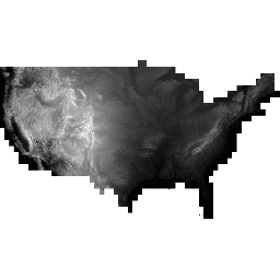
This dataset is a seamless 3DEP DEM for the U.S., covering the 48 conterminous states, Hawaii, and U.S. territories, with partial and expanding coverage in Alaska.
-
The dataset provides elevation data with a ground spacing of approximately 10 meters north/south.
-
This dataset has been superseded by USGS/3DEP/10m_collection.
-
Information from this dataset generally resides in the public domain and can be used without restriction, although crediting the USGS is encouraged.
-
The dataset is available for analysis and visualization using Google Earth Engine.
- Dataset Availability
- 1998-08-16T00:00:00Z–2020-05-06T00:00:00Z
- Dataset Producer
- United States Geological Survey
- Tags
Description
This is the seamless 3DEP DEM dataset for the U.S. with full coverage of the 48 conterminous states, Hawaii, and U.S. territories. Alaska coverage is partially available now and is being expanded to statewide coverage as part of the Alaska Mapping Initiative. Ground spacing is approximately 10 meters north/south, but variable east/west due to convergence of meridians with latitude.
Spatial metadata dataset is ingested as a separate asset USGS_3DEP_10m_metadata.
The 1m dataset is ingested as USGS_3DEP_1m.
Dataset uploaded by Farmers Business Network.
Bands
Bands
Pixel size: 10.2 meters (all bands)
| Name | Units | Pixel Size | Description |
|---|---|---|---|
elevation |
m | 10.2 meters | Elevation |
Terms of Use
Terms of Use
Most U.S. Geological Survey (USGS) information resides in the public domain and may be used without restriction. Additional information on Acknowledging or Crediting USGS as Information Source is available.
Citations
U.S. Geological Survey, 3D Elevation Program 10-Meter Resolution Digital Elevation Model.
Explore with Earth Engine
Code Editor (JavaScript)
var dataset = ee.Image('USGS/3DEP/10m')
var elevation = dataset.select('elevation');
var slope = ee.Terrain.slope(elevation);
Map.setCenter(-112.8598, 36.2841, 10);
Map.addLayer(elevation, {min: 0, max: 3000,   palette: [
    '3ae237', 'b5e22e', 'd6e21f', 'fff705', 'ffd611', 'ffb613', 'ff8b13',
    'ff6e08', 'ff500d', 'ff0000', 'de0101', 'c21301', '0602ff', '235cb1',
    '307ef3', '269db1', '30c8e2', '32d3ef', '3be285', '3ff38f', '86e26f'
  ],
}, 'elevation');
Map.addLayer(slope, {min: 0, max: 60}, 'slope');