- Dataset-Verfügbarkeit
- 2012-04-01T00:00:00Z–2026-04-01T00:00:00Z
- Ersteller des Datasets
- Earth Observation Group, Payne Institute for Public Policy, Colorado School of Mines
- Intervall
- 1 Monat
- Tags
Beschreibung
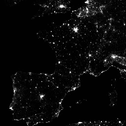
Monatliche durchschnittliche Strahlungszusammensetzungen mit Daten aus dem Tag/Nacht-Band (Day/Night Band, DNB) der Visible Infrared Imaging Radiometer Suite (VIIRS).
Da diese Daten monatlich zusammengesetzt werden, gibt es viele Gebiete auf der Welt, in denen es unmöglich ist, für den jeweiligen Monat eine gute Datenabdeckung zu erzielen. Das kann an der Wolkendecke liegen, insbesondere in den tropischen Regionen, oder an der Sonneneinstrahlung, wie sie in den Sommermonaten in den jeweiligen Polregionen auftritt. Daher wird Nutzern dieser Daten empfohlen, das Band „cf_cvg“ zu verwenden und nicht davon auszugehen, dass ein Wert von null im Bild der durchschnittlichen Strahlung bedeutet, dass keine Lichter beobachtet wurden.
Die Wolkendecke wird mit dem VIIRS Cloud Mask-Produkt (VCM) bestimmt. Außerdem werden Daten in der Nähe der Ränder des Streifens nicht in die Composites aufgenommen (Aggregationszonen 29–32). Version 1 wurde NICHT gefiltert, um Lichtquellen wie Aurora, Feuer, Boote und andere temporäre Lichtquellen herauszufiltern. Diese Trennung befindet sich in der Entwicklung und wird in einer späteren Version dieser Zeitreihe berücksichtigt. Außerdem wird eine Methode entwickelt, um Licht von Hintergrundwerten (Nicht-Licht) zu trennen.
Vor der Mittelwertbildung werden die DNB-Daten gefiltert, um Daten auszuschließen, die durch Streulicht, Blitze, Mondlicht und Wolken beeinflusst werden.
Bänder
Bänder
Pixelgröße: 463,83 Meter (alle Bänder)
| Name | Einheiten | Min. | Max. | Pixelgröße | Beschreibung |
|---|---|---|---|---|---|
avg_rad |
nanoWatts/sr/cm^2 | -1,5* | 340573* | 463,83 Meter | Durchschnittliche DNB-Strahlungswerte. |
cf_cvg |
0* | 58* | 463,83 Meter | Wolkenfreie Abdeckungen; die Gesamtzahl der Beobachtungen, die in jedes Pixel eingeflossen sind. Anhand dieses Bereichs lassen sich Gebiete mit einer geringen Anzahl von Beobachtungen ermitteln, in denen die Qualität geringer ist. |
Nutzungsbedingungen
Nutzungsbedingungen
Daten, Informationen und Produkte der Colorado School of Mines unterliegen unabhängig von der Art der Bereitstellung keinem Urheberrecht und es gibt keine Einschränkungen für die spätere Nutzung durch die Öffentlichkeit. Sobald sie vorliegen, können sie für jeden rechtmäßigen Zweck verwendet werden. Die oben genannten Daten sind frei von Urheberrechten und können ohne Einschränkungen verwendet und weitergegeben werden.
Die Earth Engine nutzen
Code-Editor (JavaScript)
var dataset = ee.ImageCollection('NOAA/VIIRS/DNB/MONTHLY_V1/VCMCFG')
                  .filter(ee.Filter.date('2017-05-01', '2017-05-31'));
var nighttime = dataset.select('avg_rad');
var nighttimeVis = {min: 0.0, max: 60.0};
Map.setCenter(-77.1056, 38.8904, 8);
Map.addLayer(nighttime, nighttimeVis, 'Nighttime');
import ee
import geemap.core as geemap
Colab (Python)
dataset = ee.ImageCollection('NOAA/VIIRS/DNB/MONTHLY_V1/VCMCFG').filter(
    ee.Filter.date('2017-05-01', '2017-05-31')
)

nighttime = dataset.select('avg_rad')

nighttime_vis = {'min': 0.0, 'max': 60.0}

m = geemap.Map()
m.set_center(-77.1056, 38.8904, 8)
m.add_layer(nighttime, nighttime_vis, 'Nighttime')
m