PERSIANN-CDR is a daily quasi-global precipitation product
that spans the period from 1983-01-01 to present. The data is
produced quarterly, with a typical lag of three months. The product
is developed by the Center for Hydrometeorology and Remote Sensing
at the University of California, Irvine (UC-IRVINE/CHRS) using
Gridded Satellite (GridSat-B1) IR data that are derived from merging
ISCCP B1 IR data, along with GPCP version 2.2.
Cite this dataset when used as a source: Sorooshian, Soroosh;
Hsu, Kuolin; Braithwaite, Dan; Ashouri, Hamed; and NOAA CDR Program
(2014): NOAA Climate Data Record (CDR) of Precipitation Estimation
from Remotely Sensed Information using Artificial Neural Networks
(PERSIANN-CDR), Version 1 Revision 1. [indicate subset used]. NOAA
National Centers for Environmental Information. doi:
doi:10.7289/V51V5BWQ
[access date].
Publications using this dataset should also cite the following
journal article: Ashouri H., K. Hsu, S. Sorooshian, D. K. Braithwaite,
K. R. Knapp, L. D. Cecil, B. R. Nelson, and O. P. Prat, 2015: PERSIANN-CDR:
Daily Precipitation Climate Data Record from Multi-Satellite Observations
for Hydrological and Climate Studies. Bull. Amer. Meteor. Soc.,
doi:10.1175/BAMS-D-13-00068.1.
PERSIANN-CDR is a daily quasi-global precipitation product that spans the period from 1983-01-01 to present. The data is produced quarterly, with a typical lag of three months. The product is developed by the Center for Hydrometeorology and Remote Sensing at the University of California, Irvine (UC-IRVINE/CHRS) using Gridded Satellite (GridSat-B1) …
[[["Easy to understand","easyToUnderstand","thumb-up"],["Solved my problem","solvedMyProblem","thumb-up"],["Other","otherUp","thumb-up"]],[["Missing the information I need","missingTheInformationINeed","thumb-down"],["Too complicated / too many steps","tooComplicatedTooManySteps","thumb-down"],["Out of date","outOfDate","thumb-down"],["Samples / code issue","samplesCodeIssue","thumb-down"],["Other","otherDown","thumb-down"]],[],[[["\u003cp\u003ePERSIANN-CDR provides daily, quasi-global precipitation data from 1983 to the present, produced by UC Irvine using satellite data.\u003c/p\u003e\n"],["\u003cp\u003eThe data is available at a 27.83 km resolution and represents estimated daily precipitation in millimeters.\u003c/p\u003e\n"],["\u003cp\u003ePERSIANN-CDR is a Climate Data Record (CDR) and is freely available for use with no restrictions.\u003c/p\u003e\n"],["\u003cp\u003eThe dataset is updated quarterly with a typical lag of three months.\u003c/p\u003e\n"],["\u003cp\u003eIt is accessible through Google Earth Engine and can be explored using provided code snippets.\u003c/p\u003e\n"]]],["The NOAA PERSIANN-CDR dataset provides daily, quasi-global precipitation data from 1983-01-01 to 2024-03-31, updated quarterly. This product, created by UC-IRVINE/CHRS, uses Gridded Satellite IR data and GPCP version 2.2. Data is available via the NOAA NCDC, and Earth Engine, as an ImageCollection, using 'precipitation' data, with a pixel size of 27830 meters. Users are encouraged to cite provided publications and DOIs when using this freely available dataset.\n"],null,["Dataset Availability\n: 1983-01-01T00:00:00Z--2024-09-30T00:00:00Z\n\nDataset Provider\n:\n\n\n [NOAA NCDC](https://doi.org/10.7289/V51V5BWQ)\n\nCadence\n: 1 Day\n\nTags\n:\n [cdr](/earth-engine/datasets/tags/cdr) [climate](/earth-engine/datasets/tags/climate) [geophysical](/earth-engine/datasets/tags/geophysical) [noaa](/earth-engine/datasets/tags/noaa) [precipitation](/earth-engine/datasets/tags/precipitation) [weather](/earth-engine/datasets/tags/weather) \n ncdc \npersiann \n\nDescription \nPERSIANN-CDR is a daily quasi-global precipitation product\nthat spans the period from 1983-01-01 to present. The data is\nproduced quarterly, with a typical lag of three months. The product\nis developed by the Center for Hydrometeorology and Remote Sensing\nat the University of California, Irvine (UC-IRVINE/CHRS) using\nGridded Satellite (GridSat-B1) IR data that are derived from merging\nISCCP B1 IR data, along with GPCP version 2.2.\n\nBands\n\n\n**Pixel Size**\n\n27830 meters\n\n**Bands**\n\n| Name | Units | Min | Max | Description |\n|-----------------|-------|-----|----------|-------------------------------|\n| `precipitation` | mm | 0\\* | 718.62\\* | Estimated daily precipitation |\n\n\\* estimated min or max value\n\nTerms of Use\n\n**Terms of Use**\n\nCDR data sets are nonproprietary, publicly available,\nand no restrictions are placed upon their use. For additional information,\nsee the [Fair Use of NOAA's CDR Data Sets, Algorithms and Documentation](https://www.ncdc.noaa.gov/sites/default/files/cdr-documentation/UseAgreement_0.pdf)\ndocument.\n\nCitations \nCitations:\n\n- Cite this dataset when used as a source: Sorooshian, Soroosh;\n Hsu, Kuolin; Braithwaite, Dan; Ashouri, Hamed; and NOAA CDR Program\n (2014): NOAA Climate Data Record (CDR) of Precipitation Estimation\n from Remotely Sensed Information using Artificial Neural Networks\n (PERSIANN-CDR), Version 1 Revision 1. \\[indicate subset used\\]. NOAA\n National Centers for Environmental Information. doi:\n [doi:10.7289/V51V5BWQ](https://doi.org/10.7289/V51V5BWQ)\n \\[access date\\].\n- Publications using this dataset should also cite the following\n journal article: Ashouri H., K. Hsu, S. Sorooshian, D. K. Braithwaite,\n K. R. Knapp, L. D. Cecil, B. R. Nelson, and O. P. Prat, 2015: PERSIANN-CDR:\n Daily Precipitation Climate Data Record from Multi-Satellite Observations\n for Hydrological and Climate Studies. Bull. Amer. Meteor. Soc.,\n [doi:10.1175/BAMS-D-13-00068.1](https://doi.org/10.1175/BAMS-D-13-00068.1).\n\nDOIs\n\n- \u003chttps://doi.org/10.1175/BAMS-D-13-00068.1\u003e\n- \u003chttps://doi.org/10.7289/V51V5BWQ\u003e\n\nExplore with Earth Engine **Important:** Earth Engine is a platform for petabyte-scale scientific analysis and visualization of geospatial datasets, both for public benefit and for business and government users. Earth Engine is free to use for research, education, and nonprofit use. To get started, please [register for Earth Engine access.](https://console.cloud.google.com/earth-engine)\n\n
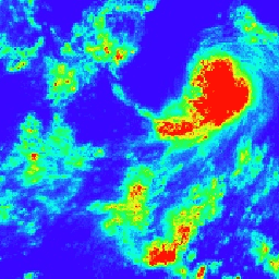
Code Editor (JavaScript) \n\n```javascript\nvar dataset = ee.ImageCollection('NOAA/PERSIANN-CDR')\n .filter(ee.Filter.date('2017-05-01', '2017-05-02'));\nvar precipitation = dataset.select('precipitation');\nvar precipitationVis = {\n min: 0.0,\n max: 50.0,\n palette: ['3907ff', '03fff3', '28ff25', 'fbff09', 'ff1105'],\n};\nMap.setCenter(113.03, 3.34, 3);\nMap.addLayer(precipitation, precipitationVis, 'Precipitation');\n```\n[Open in Code Editor](https://code.earthengine.google.com/?scriptPath=Examples:Datasets/NOAA/NOAA_PERSIANN-CDR) \n[PERSIANN-CDR: Precipitation Estimation From Remotely Sensed Information Using Artificial Neural Networks-Climate Data Record](/earth-engine/datasets/catalog/NOAA_PERSIANN-CDR) \nPERSIANN-CDR is a daily quasi-global precipitation product that spans the period from 1983-01-01 to present. The data is produced quarterly, with a typical lag of three months. The product is developed by the Center for Hydrometeorology and Remote Sensing at the University of California, Irvine (UC-IRVINE/CHRS) using Gridded Satellite (GridSat-B1) ... \nNOAA/PERSIANN-CDR, cdr,climate,geophysical,noaa,precipitation,weather \n1983-01-01T00:00:00Z/2024-09-30T00:00:00Z \n-60 -180 60 180 \nGoogle Earth Engine \nhttps://developers.google.com/earth-engine/datasets\n\n- [https://doi.org/10.7289/V51V5BWQ](https://doi.org/https://doi.org/10.7289/V51V5BWQ)\n- [https://doi.org/10.7289/V51V5BWQ](https://doi.org/https://developers.google.com/earth-engine/datasets/catalog/NOAA_PERSIANN-CDR)"]]