Page Summary
-
The MODIS MCD12C1 Version 6.1 data product provides spatially aggregated and reprojected land cover data.
-
The dataset includes land classification schemes from IGBP, UMD, and LAI at yearly intervals and a 0.05-degree spatial resolution.
-
Sub-pixel land cover class proportions and quality assessment information are also provided for each scheme.
-
Data is available from 2001 to 2024 with no restrictions on use, sale, or redistribution.
-
The data product includes bands for the majority land cover type and percent cover for each class across the three classification schemes.
- Dataset Availability
- 2001-01-01T00:00:00Z–2024-01-01T00:00:00Z
- Dataset Producer
- NASA LP DAAC at the USGS EROS Center
- Cadence
- 1 Year
- Tags
Description
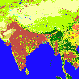
The Terra and Aqua combined Moderate Resolution Imaging Spectroradiometer (MODIS) Land Cover Climate Modeling Grid (CMG) (MCD12C1) Version 6.1 data product provides a spatially aggregated and reprojected version of the tiled MCD12Q1 Version 6.1 data product. Maps of the International Geosphere-Biosphere Programme (IGBP), University of Maryland (UMD), and Leaf Area Index (LAI) classification schemes are provided at yearly intervals at 0.05 degree (5,600 meter) spatial resolution for the entire globe from 2001 to 2022. Additionally, sub-pixel proportions of each land cover class in each 0.05 degree pixel is provided along with the aggregated quality assessment information for each of the three land classification schemes.
Provided in each MCD12C1 Version 6.1 Hierarchical Data Format 4 (HDF4) file are layers for Majority Land Cover Type 1-3, Majority Land Cover Type 1-3 Assessment, and Land Cover Type 1-3 Percent for each class.
Documentation:
Bands
Bands
Pixel size: 5600 meters (all bands)
| Name | Units | Min | Max | Pixel Size | Description |
|---|---|---|---|---|---|
Majority_Land_Cover_Type_1 |
0 | 16 | 5600 meters | Majority Land Cover Type 1: Most likely IGBP class for each 0.05 degree pixel |
|
Majority_Land_Cover_Type_1_Assessment |
% | 0 | 100 | 5600 meters | Majority Land Cover Type 1 Assessment: Majority IGBP class confidence |
Land_Cover_Type_1_Percent_Class_0 |
% | 0 | 100 | 5600 meters | Percent cover of IGBP class 0 (Water Bodies) at each pixel |
Land_Cover_Type_1_Percent_Class_1 |
% | 0 | 100 | 5600 meters | Percent cover of IGBP class 1 (Evergreen Needleleaf Forests) at each pixel |
Land_Cover_Type_1_Percent_Class_2 |
% | 0 | 100 | 5600 meters | Percent cover of IGBP class 2 (Evergreen Broadleaf Forests) at each pixel |
Land_Cover_Type_1_Percent_Class_3 |
% | 0 | 100 | 5600 meters | Percent cover of IGBP class 3 (Deciduous Needleleaf Forests) at each pixel |
Land_Cover_Type_1_Percent_Class_4 |
% | 0 | 100 | 5600 meters | Percent cover of IGBP class 4 (Deciduous Broadleaf Forests) at each pixel |
Land_Cover_Type_1_Percent_Class_5 |
% | 0 | 100 | 5600 meters | Percent cover of IGBP class 5 (Mixed Forests) at each pixel |
Land_Cover_Type_1_Percent_Class_6 |
% | 0 | 100 | 5600 meters | Percent cover of IGBP class 6 (Closed Shrublands) at each pixel |
Land_Cover_Type_1_Percent_Class_7 |
% | 0 | 100 | 5600 meters | Percent cover of IGBP class 7 (Open Shrublands) at each pixel |
Land_Cover_Type_1_Percent_Class_8 |
% | 0 | 100 | 5600 meters | Percent cover of IGBP class 8 (Woody Savannas) at each pixel |
Land_Cover_Type_1_Percent_Class_9 |
% | 0 | 100 | 5600 meters | Percent cover of IGBP class 9 (Savannas) at each pixel |
Land_Cover_Type_1_Percent_Class_10 |
% | 0 | 100 | 5600 meters | Percent cover of IGBP class 10 (Grasslands) at each pixel |
Land_Cover_Type_1_Percent_Class_11 |
% | 0 | 100 | 5600 meters | Percent cover of IGBP class 11 (Permanent Wetlands) at each pixel |
Land_Cover_Type_1_Percent_Class_12 |
% | 0 | 100 | 5600 meters | Percent cover of IGBP class 12 (Croplands) at each pixel |
Land_Cover_Type_1_Percent_Class_13 |
% | 0 | 100 | 5600 meters | Percent cover of IGBP class 13 (Urban and Built-up Lands) at each pixel |
Land_Cover_Type_1_Percent_Class_14 |
% | 0 | 100 | 5600 meters | Percent cover of IGBP class 14 (Cropland/Natural Vegetation Mosaics) at each pixel |
Land_Cover_Type_1_Percent_Class_15 |
% | 0 | 100 | 5600 meters | Percent cover of IGBP class 15 (Permanent Snow and Ice) at each pixel |
Land_Cover_Type_1_Percent_Class_16 |
% | 0 | 100 | 5600 meters | Percent cover of IGBP class 16 (Barren) at each pixel |
Majority_Land_Cover_Type_2 |
0 | 15 | 5600 meters | Majority Land Cover Type 2: Most likely UMD class for each 0.05 degree pixel |
|
Majority_Land_Cover_Type_2_Assessment |
% | 0 | 100 | 5600 meters | Majority Land Cover Type 2 Assessment: Majority UMD class confidence |
Land_Cover_Type_2_Percent_Class_0 |
% | 0 | 100 | 5600 meters | Percent cover of UMD class 0 (Water Bodies) at each pixel |
Land_Cover_Type_2_Percent_Class_1 |
% | 0 | 100 | 5600 meters | Percent cover of UMD class 1 (Evergreen Needleleaf Forests) at each pixel |
Land_Cover_Type_2_Percent_Class_2 |
% | 0 | 100 | 5600 meters | Percent cover of UMD class 2 (Evergreen Broadleaf Forests) at each pixel |
Land_Cover_Type_2_Percent_Class_3 |
% | 0 | 100 | 5600 meters | Percent cover of UMD class 3 (Deciduous Needleleaf Forests) at each pixel |
Land_Cover_Type_2_Percent_Class_4 |
% | 0 | 100 | 5600 meters | Percent cover of UMD class 4 (Deciduous Broadleaf Forests) at each pixel |
Land_Cover_Type_2_Percent_Class_5 |
% | 0 | 100 | 5600 meters | Percent cover of UMD class 5 (Mixed Forests) at each pixel |
Land_Cover_Type_2_Percent_Class_6 |
% | 0 | 100 | 5600 meters | Percent cover of UMD class 6 (Closed Shrublands) at each pixel |
Land_Cover_Type_2_Percent_Class_7 |
% | 0 | 100 | 5600 meters | Percent cover of UMD class 7 (Open Shrublands) at each pixel |
Land_Cover_Type_2_Percent_Class_8 |
% | 0 | 100 | 5600 meters | Percent cover of UMD class 8 (Woody Savannas) at each pixel |
Land_Cover_Type_2_Percent_Class_9 |
% | 0 | 100 | 5600 meters | Percent cover of UMD class 9 (Savannas) at each pixel |
Land_Cover_Type_2_Percent_Class_10 |
% | 0 | 100 | 5600 meters | Percent cover of UMD class 10 (Grasslands) at each pixel |
Land_Cover_Type_2_Percent_Class_11 |
% | 0 | 100 | 5600 meters | Percent cover of UMD class 11 (Croplands) at each pixel. (Note that "Croplands" has value 12 in Majority_Land_Cover_Type_2 to match IGBP.) |
Land_Cover_Type_2_Percent_Class_12 |
% | 0 | 100 | 5600 meters | Percent cover of UMD class 12 (Urban and Built-up Lands) at each pixel. (Note that "Urban and Built-up Lands" has value 13 in Majority_Land_Cover_Type_2 to match IGBP.) |
Land_Cover_Type_2_Percent_Class_13 |
% | 0 | 100 | 5600 meters | Percent cover of UMD class 13 (Barren) at each pixel. (Note that "Barren" has value 15 in Majority_Land_Cover_Type_2.) |
Majority_Land_Cover_Type_3 |
0 | 10 | 5600 meters | Majority Land Cover Type 3: Most likely LAI class for each 0.05 degree pixel |
|
Majority_Land_Cover_Type_3_Assessment |
% | 0 | 100 | 5600 meters | Majority Land Cover Type 3 Assessment: Majority LAI class confidence |
Land_Cover_Type_3_Percent_Class_0 |
% | 0 | 100 | 5600 meters | Percent cover of LAI class 0 (Water Bodies) at each pixel |
Land_Cover_Type_3_Percent_Class_1 |
% | 0 | 100 | 5600 meters | Percent cover of LAI class 1 (Grasslands) at each pixel |
Land_Cover_Type_3_Percent_Class_2 |
% | 0 | 100 | 5600 meters | Percent cover of LAI class 2 (Shrublands) at each pixel |
Land_Cover_Type_3_Percent_Class_3 |
% | 0 | 100 | 5600 meters | Percent cover of LAI class 3 (Broadleaf Croplands) at each pixel |
Land_Cover_Type_3_Percent_Class_4 |
% | 0 | 100 | 5600 meters | Percent cover of LAI class 4 (Savannas) at each pixel |
Land_Cover_Type_3_Percent_Class_5 |
% | 0 | 100 | 5600 meters | Percent cover of LAI class 5 (Evergreen Broadleaf Forests) at each pixel |
Land_Cover_Type_3_Percent_Class_6 |
% | 0 | 100 | 5600 meters | Percent cover of LAI class 6 (Deciduous Broadleaf Forests) at each pixel |
Land_Cover_Type_3_Percent_Class_7 |
% | 0 | 100 | 5600 meters | Percent cover of LAI class 7 (Evergreen Needleleaf Forests) at each pixel |
Land_Cover_Type_3_Percent_Class_8 |
% | 0 | 100 | 5600 meters | Percent cover of LAI class 8 (Deciduous Needleleaf Forests) at each pixel |
Land_Cover_Type_3_Percent_Class_9 |
% | 0 | 100 | 5600 meters | Percent cover of LAI class 9 (Unvegetated) at each pixel |
Land_Cover_Type_3_Percent_Class_10 |
% | 0 | 100 | 5600 meters | Percent cover of LAI class 10 (Urban and Built-up Lands) at each pixel |
Majority_Land_Cover_Type_1 Class Table
| Value | Color | Description |
|---|---|---|
| 0 | #1c0dff | Water Bodies: at least 60% of area is covered by permanent water bodies. |
| 1 | #05450a | Evergreen Needleleaf Forests: dominated by evergreen conifer trees (canopy >2m). Tree cover >60%. |
| 2 | #086a10 | Evergreen Broadleaf Forests: dominated by evergreen broadleaf and palmate trees (canopy >2m). Tree cover >60%. |
| 3 | #54a708 | Deciduous Needleleaf Forests: dominated by deciduous needleleaf (larch) trees (canopy >2m). Tree cover >60%. |
| 4 | #78d203 | Deciduous Broadleaf Forests: dominated by deciduous broadleaf trees (canopy >2m). Tree cover >60%. |
| 5 | #009900 | Mixed Forests: dominated by neither deciduous nor evergreen (40-60% of each) tree type (canopy >2m). Tree cover >60%. |
| 6 | #c6b044 | Closed Shrublands: dominated by woody perennials (1-2m height) >60% cover. |
| 7 | #dcd159 | Open Shrublands: dominated by woody perennials (1-2m height) 10-60% cover. |
| 8 | #dade48 | Woody Savannas: tree cover 30-60% (canopy >2m). |
| 9 | #fbff13 | Savannas: tree cover 10-30% (canopy >2m). |
| 10 | #b6ff05 | Grasslands: dominated by herbaceous annuals (<2m). |
| 11 | #27ff87 | Permanent Wetlands: permanently inundated lands with 30-60% water cover and >10% vegetated cover. |
| 12 | #c24f44 | cropland. |
| 13 | #a5a5a5 | Urban and Built-up Lands: at least 30% impervious surface area including building materials, asphalt and vehicles. |
| 14 | #ff6d4c | Cropland/Natural Vegetation Mosaics: mosaics of small-scale cultivation 40-60% with natural tree, shrub, or herbaceous vegetation. |
| 15 | #69fff8 | Permanent Snow and Ice: at least 60% of area is covered by snow and ice for at least 10 months of the year. |
| 16 | #f9ffa4 | (sand, rock, soil) areas with less than 10% vegetation. |
Majority_Land_Cover_Type_2 Class Table
| Value | Color | Description |
|---|---|---|
| 0 | #1c0dff | Water Bodies: at least 60% of area is covered by permanent water bodies. |
| 1 | #05450a | Evergreen Needleleaf Forests: dominated by evergreen conifer trees (canopy >2m). Tree cover >60%. |
| 2 | #086a10 | Evergreen Broadleaf Forests: dominated by evergreen broadleaf and palmate trees (canopy >2m). Tree cover >60%. |
| 3 | #54a708 | Deciduous Needleleaf Forests: dominated by deciduous needleleaf (larch) trees (canopy >2m). Tree cover >60%. |
| 4 | #78d203 | Deciduous Broadleaf Forests: dominated by deciduous broadleaf trees (canopy >2m). Tree cover >60%. |
| 5 | #009900 | Mixed Forests: dominated by neither deciduous nor evergreen (40-60% of each) tree type (canopy >2m). Tree cover >60%. |
| 6 | #c6b044 | Closed Shrublands: dominated by woody perennials (1-2m height) >60% cover. |
| 7 | #dcd159 | Open Shrublands: dominated by woody perennials (1-2m height) 10-60% cover. |
| 8 | #dade48 | Woody Savannas: tree cover 30-60% (canopy >2m). |
| 9 | #fbff13 | Savannas: tree cover 10-30% (canopy >2m). |
| 10 | #b6ff05 | Grasslands: dominated by herbaceous annuals (<2m). |
| 12 | #c24f44 | cropland. |
| 13 | #a5a5a5 | Urban and Built-up Lands: at least 30% impervious surface area including building materials, asphalt and vehicles. |
| 15 | #f9ffa4 | non-vegetated barren (sand, rock, soil) or permanent snow and ice with less than 10% vegetation. |
Majority_Land_Cover_Type_3 Class Table
| Value | Color | Description |
|---|---|---|
| 0 | #1c0dff | Water Bodies: at least 60% of area is covered by permanent water bodies. |
| 1 | #b6ff05 | Grasslands: dominated by herbaceous annuals (<2m) including cereal croplands. |
| 2 | #dcd159 | Shrublands: shrub (1-2m) cover >10%. |
| 3 | #c24f44 | Broadleaf Croplands: bominated by herbaceous annuals (<2m) that are cultivated with broadleaf crops. |
| 4 | #fbff13 | Savannas: between 10-60% tree cover (>2m). |
| 5 | #086a10 | Evergreen Broadleaf Forests: dominated by evergreen broadleaf and palmate trees (canopy >2m). Tree cover >60%. |
| 6 | #78d203 | Deciduous Broadleaf Forests: dominated by deciduous broadleaf trees (canopy >2m). Tree cover >60%. |
| 7 | #05450a | Evergreen Needleleaf Forests: dominated by evergreen conifer trees (canopy >2m). Tree cover >60%. |
| 8 | #54a708 | Deciduous Needleleaf Forests: dominated by deciduous needleleaf (larch) trees (canopy >2m). Tree cover >60%. |
| 9 | #f9ffa4 | non-vegetated barren (sand, rock, soil) or permanent snow and ice with less than 10% vegetation. |
| 10 | #a5a5a5 | Urban and Built-up Lands: at least 30% impervious surface area including building materials, asphalt and vehicles. |
Terms of Use
Terms of Use
MODIS data and products acquired through the LP DAAC have no restrictions on subsequent use, sale, or redistribution.
Citations
Please visit LP DAAC 'Citing Our Data' page for information on citing LP DAAC datasets.
DOIs
Explore with Earth Engine
Code Editor (JavaScript)
var dataset = ee.ImageCollection('MODIS/061/MCD12C1');
var igbpLandCover = dataset.select('Majority_Land_Cover_Type_1');
var igbpLandCoverVis = {
  min: 0,
  max: 16.0,
  palette: [
    '1c0dff', '05450a', '086a10', '54a708', '78d203', '009900', 'c6b044', 'dcd159',
    'dade48', 'fbff13', 'b6ff05', '27ff87', 'c24f44', 'a5a5a5', 'ff6d4c',
    '69fff8', 'f9ffa4'
  ],
};
Map.setCenter(6.746, 46.529, 2);
Map.addLayer(igbpLandCover, igbpLandCoverVis, 'IGBP Land Cover');