The map features you can customize are arranged in a hierarchy, and each map feature has one more style elements that you can customize. Most top-level features have one or more child map features. You have several options when customizing map styles:
Inherit from the base map style: If you don't customize a style element for a map feature, it inherits the default style from the base map.
Inherit from parents: Customize a style element on a parent map feature, to have all un-customized child map features below inherit the styles from their parent.
Override the parent style: Customize a style element on a child map feature to override the parent style for that element.
Customize zoom levels: For some map features, you can customize style elements for different zoom levels. For details, see Style zoom levels.
What you can style for each map feature
Map features can have one or more of the following style elements that you can customize, depending on the type of map feature:
Visibility: Whether to show or hide this feature on the map. For details, see Display or hide map features.
Fill color: Fill color for polygons and polylines.
Stroke color: Outline color for polygons and polylines.
Stroke weight: Thickness of the outline line for polygons and polylines. Can't be set to 0. If you don't want an outline, set the Stroke color to the same as the Fill color.
Icon color: Fill color for the icons.
Text fill color: Fill color for text labels.
Text stroke color: Outline color for text labels.
Display or hide map features
If there are map features that you either want to display or hide on your map, use the Visibility style element:
In the style editor, select the map feature.
To display the map feature: Under Visibility, select On.
To remove the map feature from the map: Under Visibility, select Off.
Polygons and Polylines
For map feature types that are represented with a shape, such as Beach, Country, and Town square, or a line, such as Rail, Highway, and Trail, you can typically style the following elements: Visibility, Fill color, Stroke color, and Stroke weight.
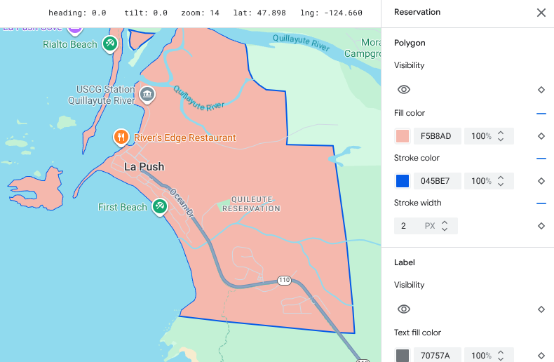
Polygon styling customization example - for Reservation feature type
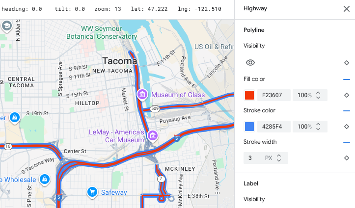
Polyline styling customization example - for Highway feature type
Icons and Text Labels
For map feature types that are fully or partially represented with a label, such as Points of interest or Transportation, you can usually style the following elements: Visibility, Icon color, Text fill color, and Text stroke color.
![]()
Label text and icon styling customizations example
Map feature hierarchy
These tables for the top level map features show what child map features are available under each.
Points of interest |
|
|---|---|
| Emergency | Fire Hospital Pharmacy Police |
| Entertainment | Arts Casino Cinema Historic Museum Theme park Tourist attraction |
| Food and drink | Bar Cafe Restaurant Winery |
| Lodging | |
| Recreation | Beach Boating Fishing Golf course Hot spring Nature reserve Park Peak Sports complex Sports field Trailhead Zoo |
| Retail | Grocery Shopping |
| Services | ATM Bank Car rental EV charging Gas station Parking lot Post office Rest stop Restroom |
| Transit | Airport |
| Other | Bridge Cemetery Government Library Military Place of worship School Town square |
Political |
|
|---|---|
| Country | |
| Country border | |
| Reservation | |
| State or province | |
| City | |
| Sublocality | |
| Neighborhood | |
| Land parcel | |
Infrastructure |
||
|---|---|---|
| Building | ||
| Business corridor | ||
| Road network | No traffic | Pedestrian mall Trail |
| Parking aisle | ||
| Road shield | ||
| Roads | Arterial Highway Local No outlet |
|
| Railway track | ||
| Transit station | Bicycle share | |
| Bus station | ||
| Ferry terminal | ||
| Funicular station | ||
| Gondola station | ||
| Monorail | ||
| Rail station | Subway station Tram station |
|
| Urban area | ||
| Natural | ||
|---|---|---|
| Continent | ||
| Archipelago | ||
| Island | ||
| Land cover | Vegetation | Crops Dry crops Forest Ice Sand Shrub Tundra |
| Water | Ocean Lake River Other |
|
| Background | ||