
При заполнении адреса доставки, платежной информации или информации о мероприятии включение функции автозаполнения помогает пользователям сократить количество нажатий клавиш и ошибок при вводе адресной информации. В этом руководстве описаны шаги, необходимые для включения функции автозаполнения для поля ввода и заполнения полей адресной формы компонентами адреса, выбранного пользователем, а также отображения выбранного адреса на карте для визуального подтверждения.
Видео: Улучшите формы адресов с помощью функции автозаполнения мест.
Адресные формы
Android
iOS
Веб
Платформа Google Maps предоставляет виджет автозаполнения мест для мобильных платформ и веб-версии. Виджет, показанный на предыдущих рисунках, предоставляет диалоговое окно поиска со встроенной функцией автозаполнения, которую можно оптимизировать даже для поиска по местоположению.
Получите код
Клонируйте или загрузите репозиторий Google Places SDK for Android Demos с GitHub.
Посмотреть версию задания на Java:
    /*
 * Copyright 2022 Google LLC
 *
 * Licensed under the Apache License, Version 2.0 (the "License");
 * you may not use this file except in compliance with the License.
 * You may obtain a copy of the License at
 *
 *     https://www.apache.org/licenses/LICENSE-2.0
 *
 * Unless required by applicable law or agreed to in writing, software
 * distributed under the License is distributed on an "AS IS" BASIS,
 * WITHOUT WARRANTIES OR CONDITIONS OF ANY KIND, either express or implied.
 * See the License for the specific language governing permissions and
 * limitations under the License.
 */

package com.example.placesdemo;

import android.annotation.SuppressLint;
import android.app.Activity;
import android.content.Intent;
import android.content.pm.PackageManager;
import android.content.res.Resources;
import android.os.Bundle;
import android.util.Log;
import android.view.View;
import android.view.ViewStub;
import android.widget.Button;
import android.widget.CheckBox;
import android.widget.Toast;

import androidx.activity.result.ActivityResultLauncher;
import androidx.activity.result.contract.ActivityResultContracts;
import androidx.annotation.NonNull;
import androidx.annotation.Nullable;
import androidx.appcompat.app.AppCompatActivity;
import androidx.core.content.ContextCompat;

import com.example.placesdemo.databinding.AutocompleteAddressActivityBinding;
import com.google.android.gms.location.FusedLocationProviderClient;
import com.google.android.gms.location.LocationServices;
import com.google.android.gms.maps.CameraUpdateFactory;
import com.google.android.gms.maps.GoogleMap;
import com.google.android.gms.maps.GoogleMapOptions;
import com.google.android.gms.maps.OnMapReadyCallback;
import com.google.android.gms.maps.SupportMapFragment;
import com.google.android.gms.maps.model.LatLng;
import com.google.android.gms.maps.model.MapStyleOptions;
import com.google.android.gms.maps.model.Marker;
import com.google.android.gms.maps.model.MarkerOptions;
import com.google.android.libraries.places.api.Places;
import com.google.android.libraries.places.api.model.AddressComponent;
import com.google.android.libraries.places.api.model.AddressComponents;
import com.google.android.libraries.places.api.model.Place;
import com.google.android.libraries.places.api.model.PlaceTypes;
import com.google.android.libraries.places.api.net.PlacesClient;
import com.google.android.libraries.places.widget.Autocomplete;
import com.google.android.libraries.places.widget.model.AutocompleteActivityMode;

import java.util.Arrays;
import java.util.List;

import static android.Manifest.permission.ACCESS_FINE_LOCATION;
import static com.google.maps.android.SphericalUtil.computeDistanceBetween;
import androidx.activity.EdgeToEdge;

/**
 * Activity for using Place Autocomplete to assist filling out an address form.
 */
@SuppressWarnings("FieldCanBeLocal")
public class AutocompleteAddressActivity extends AppCompatActivity implements OnMapReadyCallback {

    private static final String TAG = "ADDRESS_AUTOCOMPLETE";
    private static final String MAP_FRAGMENT_TAG = "MAP";
    private LatLng coordinates;
    private boolean checkProximity = false;
    private SupportMapFragment mapFragment;
    private GoogleMap map;
    private Marker marker;
    private PlacesClient placesClient;
    private View mapPanel;
    private LatLng deviceLocation;
    private static final double acceptedProximity = 150;

    private AutocompleteAddressActivityBinding binding;

    View.OnClickListener startAutocompleteIntentListener = view -> {
        view.setOnClickListener(null);
        startAutocompleteIntent();
    };

    private final ActivityResultLauncher<Intent> startAutocomplete = registerForActivityResult(
            new ActivityResultContracts.StartActivityForResult(),
            result -> {
                if (result.getResultCode() == Activity.RESULT_OK) {
                    Intent intent = result.getData();
                    if (intent != null) {
                        Place place = Autocomplete.getPlaceFromIntent(intent);

                        // Write a method to read the address components from the Place
                        // and populate the form with the address components
                        Log.d(TAG, "Place: " + place.getAddressComponents());
                        fillInAddress(place);
                    }
                } else if (result.getResultCode() == Activity.RESULT_CANCELED) {
                    // The user canceled the operation.
                    Log.i(TAG, "User canceled autocomplete");
                }
            });

    @Override
    protected void onActivityResult(int requestCode, int resultCode, @Nullable Intent intent) {
        super.onActivityResult(requestCode, resultCode, intent);
        binding.autocompleteAddress1.setOnClickListener(startAutocompleteIntentListener);
    }

    @Override
    protected void onCreate(Bundle savedInstanceState) {
        // Enable edge-to-edge display. This must be called before calling super.onCreate().
        EdgeToEdge.enable(this);
        super.onCreate(savedInstanceState);

        binding = AutocompleteAddressActivityBinding.inflate(getLayoutInflater());
        setContentView(binding.getRoot());

        // Retrieve a PlacesClient (previously initialized - see MainActivity)
        placesClient = Places.createClient(this);

        // Attach an Autocomplete intent to the Address 1 EditText field
        binding.autocompleteAddress1.setOnClickListener(startAutocompleteIntentListener);

        // Update checkProximity when user checks the checkbox
        CheckBox checkProximityBox = findViewById(R.id.checkbox_proximity);
        checkProximityBox.setOnCheckedChangeListener((view, isChecked) -> {
            // Set the boolean to match user preference for when the Submit button is clicked
            checkProximity = isChecked;
        });

        // Submit and optionally check proximity
        Button saveButton = findViewById(R.id.autocomplete_save_button);
        saveButton.setOnClickListener(v -> saveForm());

        // Reset the form
        Button resetButton = findViewById(R.id.autocomplete_reset_button);
        resetButton.setOnClickListener(v -> clearForm());
    }

    private void startAutocompleteIntent() {

        // Set the fields to specify which types of place data to
        // return after the user has made a selection.
        List<Place.Field> fields = Arrays.asList(Place.Field.ADDRESS_COMPONENTS,
                Place.Field.LOCATION, Place.Field.VIEWPORT);

        // Build the autocomplete intent with field, country, and type filters applied
        Intent intent = new Autocomplete.IntentBuilder(AutocompleteActivityMode.OVERLAY, fields)
                .setCountries(List.of("US"))
                .setTypesFilter(List.of("establishment"))
                .build(this);
        startAutocomplete.launch(intent);
    }

    @Override
    public void onMapReady(@NonNull GoogleMap googleMap) {
        map = googleMap;
        try {
            // Customise the styling of the base map using a JSON object defined
            // in a string resource.
            boolean success = map.setMapStyle(
                    MapStyleOptions.loadRawResourceStyle(this, R.raw.style_json));

            if (!success) {
                Log.e(TAG, "Style parsing failed.");
            }
        } catch (Resources.NotFoundException e) {
            Log.e(TAG, "Can't find style. Error: ", e);
        }
        map.moveCamera(CameraUpdateFactory.newLatLngZoom(coordinates, 15f));
        marker = map.addMarker(new MarkerOptions().position(coordinates));
    }

    private void fillInAddress(Place place) {
        AddressComponents components = place.getAddressComponents();
        StringBuilder address1 = new StringBuilder();
        StringBuilder postcode = new StringBuilder();

        // Get each component of the address from the place details,
        // and then fill-in the corresponding field on the form.
        // Possible AddressComponent types are documented at https://goo.gle/32SJPM1
        if (components != null) {
            for (AddressComponent component : components.asList()) {
                String type = component.getTypes().get(0);
                switch (type) {
                    case "street_number": {
                        address1.insert(0, component.getName());
                        break;
                    }

                    case "route": {
                        address1.append(" ");
                        address1.append(component.getShortName());
                        break;
                    }

                    case "postal_code": {
                        postcode.insert(0, component.getName());
                        break;
                    }

                    case "postal_code_suffix": {
                        postcode.append("-").append(component.getName());
                        break;
                    }

                    case "locality":
                        binding.autocompleteCity.setText(component.getName());
                        break;

                    case "administrative_area_level_1": {
                        binding.autocompleteState.setText(component.getShortName());
                        break;
                    }

                    case "country":
                        binding.autocompleteCountry.setText(component.getName());
                        break;
                }
            }
        }

        binding.autocompleteAddress1.setText(address1.toString());
        binding.autocompletePostal.setText(postcode.toString());

        // After filling the form with address components from the Autocomplete
        // prediction, set cursor focus on the second address line to encourage
        // entry of sub-premise information such as apartment, unit, or floor number.
        binding.autocompleteAddress2.requestFocus();

        // Add a map for visual confirmation of the address
        showMap(place);
    }

    private void showMap(Place place) {
        coordinates = place.getLocation();

        // It isn't possible to set a fragment's id programmatically so we set a tag instead and
        // search for it using that.
        mapFragment = (SupportMapFragment)
                getSupportFragmentManager().findFragmentByTag(MAP_FRAGMENT_TAG);

        // We only create a fragment if it doesn't already exist.
        if (mapFragment == null) {
            mapPanel = ((ViewStub) findViewById(R.id.stub_map)).inflate();
            GoogleMapOptions mapOptions = new GoogleMapOptions();
            mapOptions.mapToolbarEnabled(false);

            // To programmatically add the map, we first create a SupportMapFragment.
            mapFragment = SupportMapFragment.newInstance(mapOptions);

            // Then we add it using a FragmentTransaction.
            getSupportFragmentManager()
                    .beginTransaction()
                    .add(R.id.confirmation_map, mapFragment, MAP_FRAGMENT_TAG)
                    .commit();
            mapFragment.getMapAsync(this);
        } else {
            updateMap(coordinates);
        }
    }

    private void updateMap(LatLng latLng) {
        marker.setPosition(latLng);
        map.moveCamera(CameraUpdateFactory.newLatLngZoom(latLng, 15f));
        if (mapPanel.getVisibility() == View.GONE) {
            mapPanel.setVisibility(View.VISIBLE);
        }
    }

    private void saveForm() {
        Log.d(TAG, "checkProximity = " + checkProximity);
        if (checkProximity) {
            checkLocationPermissions();
        } else {
            Toast.makeText(
                            this,
                            R.string.autocomplete_skipped_message,
                            Toast.LENGTH_SHORT)
                    .show();
        }
    }

    private void clearForm() {
        binding.autocompleteAddress1.setText("");
        binding.autocompleteAddress2.getText().clear();
        binding.autocompleteCity.getText().clear();
        binding.autocompleteState.getText().clear();
        binding.autocompletePostal.getText().clear();
        binding.autocompleteCountry.getText().clear();
        if (mapPanel != null) {
            mapPanel.setVisibility(View.GONE);
        }
        binding.autocompleteAddress1.requestFocus();
    }

    // Register the permissions callback, which handles the user's response to the
    // system permissions dialog. Save the return value, an instance of
    // ActivityResultLauncher, as an instance variable.
    private final ActivityResultLauncher<String> requestPermissionLauncher =
            registerForActivityResult(new ActivityResultContracts.RequestPermission(), isGranted -> {
                if (isGranted) {
                    // Since ACCESS_FINE_LOCATION is the only permission in this sample,
                    // run the location comparison task once permission is granted.
                    // Otherwise, check which permission is granted.
                    getAndCompareLocations();
                } else {
                    // Fallback behavior if user denies permission
                    Log.d(TAG, "User denied permission");
                }
            });

    private void checkLocationPermissions() {
        if (ContextCompat.checkSelfPermission(this, ACCESS_FINE_LOCATION)
                == PackageManager.PERMISSION_GRANTED) {
            getAndCompareLocations();
        } else {
            requestPermissionLauncher.launch(
                    ACCESS_FINE_LOCATION);
        }
    }

    @SuppressLint("MissingPermission")
    private void getAndCompareLocations() {
        // TODO: Detect and handle if user has entered or modified the address manually and update
        // the coordinates variable to the Lat/Lng of the manually entered address. May use
        // Geocoding API to convert the manually entered address to a Lat/Lng.
        LatLng enteredLocation = coordinates;
        map.setMyLocationEnabled(true);

        FusedLocationProviderClient fusedLocationClient =
                LocationServices.getFusedLocationProviderClient(this);

        fusedLocationClient.getLastLocation()
                .addOnSuccessListener(this, location -> {
                    // Got last known location. In some rare situations this can be null.
                    if (location == null) {
                        return;
                    }

                    deviceLocation = new LatLng(location.getLatitude(), location.getLongitude());
                    Log.d(TAG, "device location = " + deviceLocation);
                    Log.d(TAG, "entered location = " + enteredLocation.toString());

                    // Use the computeDistanceBetween function in the Maps SDK for Android Utility Library
                    // to use spherical geometry to compute the distance between two Lat/Lng points.
                    double distanceInMeters = computeDistanceBetween(deviceLocation, enteredLocation);
                    if (distanceInMeters <= acceptedProximity) {
                        Log.d(TAG, "location matched");
                        // TODO: Display UI based on the locations matching
                    } else {
                        Log.d(TAG, "location not matched");
                        // TODO: Display UI based on the locations not matching
                    }
                });
    }
}
Включение API
Для реализации этих рекомендаций необходимо включить следующие API в консоли Google Cloud:
- SDK для карт Android (или API для вашей платформы)
- API мест
Для получения дополнительной информации о настройке см. раздел «Настройка проекта Google Cloud» .
Добавление автозаполнения в поля ввода
В этом разделе описывается, как добавить функцию автозаполнения в форму адреса.
Добавление виджета автозаполнения «Местоположение»
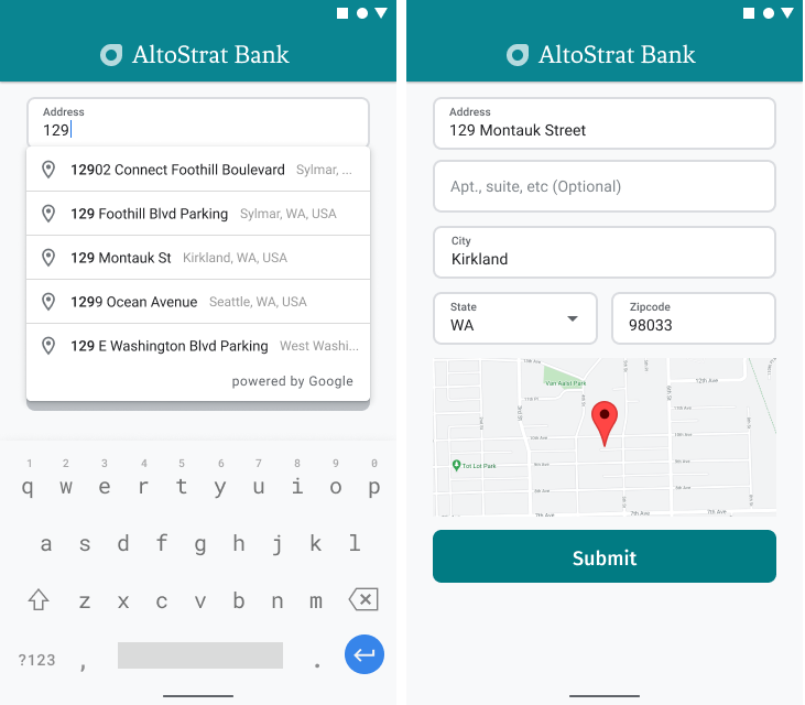
В Android можно добавить виджет автозаполнения с помощью интента Autocomplete , который запускает Place Autocomplete из поля ввода «Адресная строка 1», где пользователь начнет вводить свой адрес. Когда он начнет печатать, он сможет выбрать свой адрес из списка подсказок автозаполнения.
Сначала подготовьте средство запуска активности, используя ActivityResultLauncher , которое будет отслеживать результат запущенной активности. Функция обратного вызова для получения результата будет содержать объект Place, соответствующий адресу, который пользователь выберет из подсказок автозаполнения.
    private final ActivityResultLauncher<Intent> startAutocomplete = registerForActivityResult(
            new ActivityResultContracts.StartActivityForResult(),
            result -> {
                if (result.getResultCode() == Activity.RESULT_OK) {
                    Intent intent = result.getData();
                    if (intent != null) {
                        Place place = Autocomplete.getPlaceFromIntent(intent);

                        // Write a method to read the address components from the Place
                        // and populate the form with the address components
                        Log.d(TAG, "Place: " + place.getAddressComponents());
                        fillInAddress(place);
                    }
                } else if (result.getResultCode() == Activity.RESULT_CANCELED) {
                    // The user canceled the operation.
                    Log.i(TAG, "User canceled autocomplete");
                }
            });
Далее определите свойства полей, местоположения и типа для интента Place Autocomplete и создайте его с помощью Autocomplete.IntentBuilder . Наконец, запустите интент, используя ActivityResultLauncher определенный в предыдущем примере кода.
    private void startAutocompleteIntent() {

        // Set the fields to specify which types of place data to
        // return after the user has made a selection.
        List<Place.Field> fields = Arrays.asList(Place.Field.ADDRESS_COMPONENTS,
                Place.Field.LOCATION, Place.Field.VIEWPORT);

        // Build the autocomplete intent with field, country, and type filters applied
        Intent intent = new Autocomplete.IntentBuilder(AutocompleteActivityMode.OVERLAY, fields)
                .setCountries(List.of("US"))
                .setTypesFilter(List.of("establishment"))
                .build(this);
        startAutocomplete.launch(intent);
    }
Обработка адреса, возвращаемого функцией автозаполнения места.
Определение ActivityResultLauncher данное ранее, также определило, что должно происходить при возврате результата действия в коллбэке. Если пользователь выбрал предсказание, оно будет передано в интенте, содержащемся в объекте результата. Поскольку интент был создан с помощью Autocomplete.IntentBuilder , метод Autocomplete.getPlaceFromIntent() может извлечь из него объект Place.
    private final ActivityResultLauncher<Intent> startAutocomplete = registerForActivityResult(
            new ActivityResultContracts.StartActivityForResult(),
            result -> {
                if (result.getResultCode() == Activity.RESULT_OK) {
                    Intent intent = result.getData();
                    if (intent != null) {
                        Place place = Autocomplete.getPlaceFromIntent(intent);

                        // Write a method to read the address components from the Place
                        // and populate the form with the address components
                        Log.d(TAG, "Place: " + place.getAddressComponents());
                        fillInAddress(place);
                    }
                } else if (result.getResultCode() == Activity.RESULT_CANCELED) {
                    // The user canceled the operation.
                    Log.i(TAG, "User canceled autocomplete");
                }
            });
Затем вызовите метод Place.getAddressComponents() и сопоставьте каждый компонент адреса с соответствующим полем ввода в форме адреса, заполнив поле значением из выбранного пользователем места.
Пример реализации заполнения полей формы адреса приведен в методе fillInAddress в образце кода, представленном в разделе «Получить код» на этой странице.
Использование данных об адресе, полученных в результате прогнозирования, вместо адреса, введенного вручную, помогает обеспечить точность адреса, гарантирует, что адрес известен и по нему можно доставить посылку, а также сокращает количество нажатий клавиш пользователем.
Что следует учитывать при внедрении функции автозаполнения мест
Функция автозаполнения мест предлагает ряд опций, позволяющих гибко использовать не только виджет. Вы можете использовать комбинацию сервисов, чтобы получить именно то, что вам нужно для правильного сопоставления местоположения.
Для формы «АДРЕС» установите параметр types в
address, чтобы ограничить поиск только полными адресами улиц. Подробнее о поддерживаемых типах см. в разделе «Запросы автозаполнения» .Установите соответствующие ограничения и параметры, если вам не требуется поиск по всему миру. Существует ряд параметров, которые можно использовать для смещения или ограничения результатов поиска только определенными регионами.
Используйте
RectangularBoundsдля установки прямоугольных границ области, аsetLocationRestriction()для обеспечения возврата только адресов в этих областях.Используйте функцию
setCountries(), чтобы ограничить ответы определенным набором стран.
Оставьте поля редактируемыми на случай, если некоторые поля будут пропущены при сопоставлении, и позвольте клиентам обновлять адрес при необходимости. Поскольку большинство адресов, возвращаемых функцией автозаполнения, не содержат номеров подобъектов, таких как номера квартир, офисов или помещений, вы можете переключить фокус на строку адреса 2, чтобы побудить пользователя заполнить эту информацию при необходимости.
Визуальное подтверждение адреса.
В процессе ввода адреса предоставьте пользователям визуальное подтверждение адреса на карте. Это даст им дополнительную уверенность в правильности адреса.
На следующем рисунке ниже адреса показана карта с отметкой (булавкой) в указанном адресе.
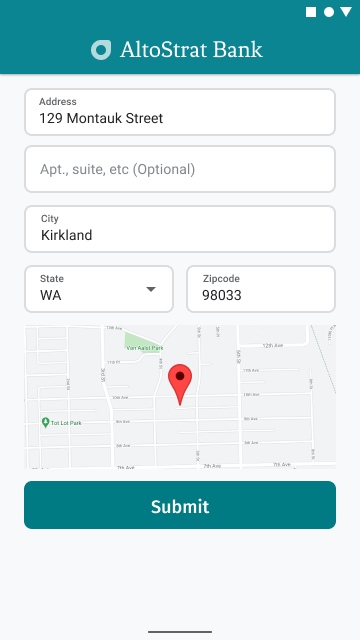
В следующем примере показаны основные шаги по добавлению карты в Android. Для получения более подробной информации обратитесь к документации.
- Добавление
SupportMapFragment(в данном случае, динамическое добавление фрагмента) - Получение доступа к фрагменту кода и регистрация функции обратного вызова.
- Оформление и добавление маркера на карту.
- Отключение элементов управления картой
Добавление SupportMapFragment
Сначала добавьте фрагмент SupportMapFragment в XML-файл макета .
    <fragment
        android:name="com.google.android.gms.maps.SupportMapFragment"
        android:id="@+id/confirmation_map"
        android:layout_width="match_parent"
        android:layout_height="match_parent"/>
Затем, если фрагмент еще не существует, добавьте его программным способом.
    private void showMap(Place place) {
        coordinates = place.getLocation();

        // It isn't possible to set a fragment's id programmatically so we set a tag instead and
        // search for it using that.
        mapFragment = (SupportMapFragment)
                getSupportFragmentManager().findFragmentByTag(MAP_FRAGMENT_TAG);

        // We only create a fragment if it doesn't already exist.
        if (mapFragment == null) {
            mapPanel = ((ViewStub) findViewById(R.id.stub_map)).inflate();
            GoogleMapOptions mapOptions = new GoogleMapOptions();
            mapOptions.mapToolbarEnabled(false);

            // To programmatically add the map, we first create a SupportMapFragment.
            mapFragment = SupportMapFragment.newInstance(mapOptions);

            // Then we add it using a FragmentTransaction.
            getSupportFragmentManager()
                    .beginTransaction()
                    .add(R.id.confirmation_map, mapFragment, MAP_FRAGMENT_TAG)
                    .commit();
            mapFragment.getMapAsync(this);
        } else {
            updateMap(coordinates);
        }
    }
Получение доступа к фрагменту кода и регистрация функции обратного вызова.
Чтобы получить дескриптор фрагмента, вызовите метод
FragmentManager.findFragmentByIdи передайте ему идентификатор ресурса фрагмента из вашего файла разметки. Если вы добавили фрагмент динамически , пропустите этот шаг, поскольку вы уже получили дескриптор.Вызовите метод
getMapAsync, чтобы установить функцию обратного вызова для фрагмента.
Например, если вы добавили фрагмент статически:
Котлин
val mapFragment = supportFragmentManager
    .findFragmentById(R.id.map) as SupportMapFragment
mapFragment.getMapAsync(this)
Java
SupportMapFragment mapFragment = (SupportMapFragment) getSupportFragmentManager()
    .findFragmentById(R.id.map);
mapFragment.getMapAsync(this);
Оформление и добавление маркера на карту.
Когда карта будет готова, задайте стиль, центрируйте камеру и добавьте маркер по координатам введенного адреса. Приведенный ниже код использует стили, определенные в объекте JSON, или вы можете загрузить идентификатор карты, определенный с помощью Cloud-based Maps Styling .
    @Override
    public void onMapReady(@NonNull GoogleMap googleMap) {
        map = googleMap;
        try {
            // Customise the styling of the base map using a JSON object defined
            // in a string resource.
            boolean success = map.setMapStyle(
                    MapStyleOptions.loadRawResourceStyle(this, R.raw.style_json));

            if (!success) {
                Log.e(TAG, "Style parsing failed.");
            }
        } catch (Resources.NotFoundException e) {
            Log.e(TAG, "Can't find style. Error: ", e);
        }
        map.moveCamera(CameraUpdateFactory.newLatLngZoom(coordinates, 15f));
        marker = map.addMarker(new MarkerOptions().position(coordinates));
    }
Отключение элементов управления картой
Чтобы карта оставалась простой и отображала местоположение без дополнительных элементов управления (таких как компас, панель инструментов или другие встроенные функции), можно отключить те элементы управления, которые вам не нужны. На Android можно также включить облегченный режим , обеспечивающий ограниченную интерактивность.