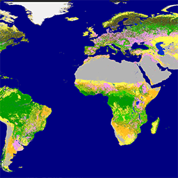
Глобальная земельная служба программы «Коперник» (CGLS) определена как компонент Земельной службы для управления многоцелевым сервисным компонентом, предоставляющим серию биогеофизических продуктов о состоянии и эволюции поверхности суши в глобальном масштабе. Динамическая карта земельного покрова доступна на…
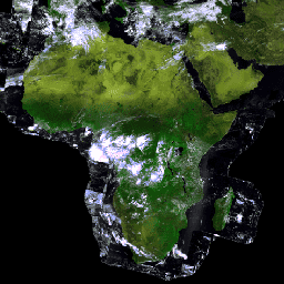
Proba-V — это спутниковая миссия, предназначенная для картирования почвенно-растительного покрова и роста растительности. Она была разработана для обеспечения преемственности оптического прибора VGT, используемого в миссиях SPOT-4 и SPOT-5. Датчик собирает данные в трёх диапазонах VNIR (видимый и ближний инфракрасный) и одном коротковолновом ИК-диапазоне (коротковолновый…
Proba-V — это спутниковая миссия, предназначенная для картирования почвенно-растительного покрова и роста растительности. Она была разработана для обеспечения преемственности оптического прибора VGT, используемого в миссиях SPOT-4 и SPOT-5. Датчик собирает данные в трёх диапазонах VNIR (видимый и ближний инфракрасный) и одном коротковолновом ИК-диапазоне (коротковолновый…
[[["Прост для понимания","easyToUnderstand","thumb-up"],["Помог мне решить мою проблему","solvedMyProblem","thumb-up"],["Другое","otherUp","thumb-up"]],[["Отсутствует нужная мне информация","missingTheInformationINeed","thumb-down"],["Слишком сложен/слишком много шагов","tooComplicatedTooManySteps","thumb-down"],["Устарел","outOfDate","thumb-down"],["Проблема с переводом текста","translationIssue","thumb-down"],["Проблемы образцов/кода","samplesCodeIssue","thumb-down"],["Другое","otherDown","thumb-down"]],[],[],[]]